Category:Maps of Avesnes-sur-Helpe
Wikimedia category | |||||
| Upload media | |||||
| Instance of | |||||
|---|---|---|---|---|---|
| Category combines topics | |||||
| Avesnes-sur-Helpe | |||||
commune in Nord, France     | |||||
| Instance of | |||||
| Named after | |||||
| Location |
| ||||
| Population |
| ||||
| Area |
| ||||
| Elevation above sea level |
| ||||
| official website | |||||
 | |||||
Subcategories
This category has the following 2 subcategories, out of 2 total.
M
Media in category "Maps of Avesnes-sur-Helpe"
The following 10 files are in this category, out of 10 total.
-
 59 NORD carte grille communale densite INSEE.png 3,507 × 2,480; 3.19 MB
-
 59-AAV2020-Avesnes-sur-Helpe.png 3,519 × 3,197; 2.45 MB
-
 59-Avesnes-sur-Helpe-AAV2020.png 3,519 × 2,930; 935 KB
-
 59036-Avesnes-sur-Helpe-Hydro.jpeg 5,846 × 4,133; 2.06 MB
-
 59036-Avesnes-sur-Helpe-Sols.png 3,270 × 2,598; 2.72 MB
-
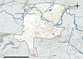
 Avesnes-sur-Helpe Limite administrative.jpg 950 × 577; 193 KB
-
 Avesnes-sur-Helpe Limite communale.jpg 951 × 574; 112 KB
-
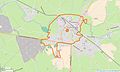
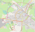 Avesnes-sur-Helpe OSM 01.png 870 × 802; 373 KB
-
 Avesnes-sur-Helpe OSM 02.png 870 × 802; 517 KB
-
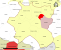
 Map commune FR insee code 59036.png 756 × 605; 28 KB


