Category:Maps of Barbary Coast
English: This category is for maps with detailed information on the "Barbary Coast" that refer to this part of the North African coast in that manner - usually old maps from the era of Barbary Pirates.
(The Barbary Coast stretched from Morocco over Algeria to Tunisia. Some maps included Mauritania, many include Libya. Egypt was not part of Barbary.)
(The Barbary Coast stretched from Morocco over Algeria to Tunisia. Some maps included Mauritania, many include Libya. Egypt was not part of Barbary.)
Subcategories
This category has the following 4 subcategories, out of 4 total.
Media in category "Maps of Barbary Coast"
The following 141 files are in this category, out of 141 total.
-

-
 Barbariae et Biledulgerid nova descriptio - btv1b85953397 (1 of 2).jpg 8,061 × 5,434; 8.76 MB
-
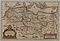
 Barbariae et Biledulgerid, Nova Descriptio.jpg 12,777 × 8,739; 16.31 MB
-
-
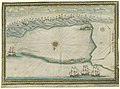
 Tavola Quinta, Che Ha Sua Superiore La Tavola Prima. Libro Terzo. Urbano Monti (1587).jpg 6,215 × 4,625; 6.33 MB
-
-
 Barbary Coast 1590.jpg 650 × 462; 115 KB
-
 Daniel Keller. Asiae nova descriptio (Antwerpen, 1590).LU9.jpg 2,138 × 1,495; 464 KB
-

-
 Map of Eastern Mediterranean. HM 34. PORTOLAN ATLAS, anonymous. France (?), ca. 1600.jpg 5,358 × 4,434; 7.34 MB
-

-

-

-
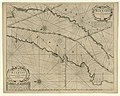
 Tabula portuum Barbariae, iunctis insuls Canariensibus - btv1b53196825f (1 of 2).jpg 4,679 × 6,482; 4.16 MB
-
 Atlas de la Méditerranée - Petrus Collin - btv1b55007092q (06 of 17).jpg 13,381 × 9,534; 19.69 MB
-
 Barbary Coast on 1644 Europa Recens by Blaeu (cropped).jpg 4,123 × 987; 3.79 MB
-
 A-3-37-15-Barbarie-Algeria.jpg 3,000 × 2,269; 899 KB
-
 A-3-37-16-Barbarie-Tunis-Tripoli.jpg 3,000 × 2,288; 862 KB
-
 Eastern Sheet - Pas caart van de Middelandsche Zee RMG F8111 (cropped).tiff 4,184 × 1,753; 20.98 MB
-
 Pas caart van de Middelandsche Zee RMG F8111 (western part).tiff 4,208 × 1,700; 20.47 MB
-
 Pas caart van de Middelandsche Zee RMG F8111.tiff 5,100 × 3,992; 58.25 MB
-

-
 Middel-landtsche Zee nieuwlix uytgegeven RMG F8095 (western part).tiff 4,619 × 1,979; 34.87 MB
-
 Atlas de la mer Méditerranée (Reprod. numérique) - par Brémond - btv1b53028104r (04 of 10).jpg 9,855 × 6,998; 11.11 MB
-
 Carte particulière de la coste de Barbarie - Bremond - btv1b59055992 (1 of 2).jpg 10,904 × 5,096; 6.45 MB
-

-
 Nova Barbariae descriptio - btv1b531712105 (1 of 2).jpg 6,361 × 4,365; 5.44 MB
-
 Nova Barbariae descriptio - btv1b85953360 (1 of 2).jpg 8,384 × 5,756; 8.77 MB
-
 Afrique Barbarie (1665 map detail).jpg 2,950 × 3,316; 1.49 MB
-

-
 Gascoyne, Straights of Gibraltar.jpg 2,175 × 1,732; 1.17 MB
-
 La Baÿe De Tanger En Barbarie - Henry Michelot - btv1b5966457b (1 of 2).jpg 5,088 × 3,504; 1.93 MB
-
 Tripoli de Barbarie - Gombaud - btv1b5905598n (1 of 2).jpg 7,648 × 5,680; 6.44 MB
-

-

-

-
 Map of Barbary (northern coast), 1683.jpg 506 × 815; 143 KB
-

-
 Atlas Van der Hagen - Barbary Coast.jpeg 3,916 × 1,554; 1.49 MB
-
 Atlas Van der Hagen-KW1049B13 057-BARBARIA.jpeg 5,500 × 4,748; 3.23 MB
-
 Atlante Veneto Volume 1 108.jpg 9,806 × 6,602; 7.3 MB
-
 UBBasel Map Maghreb 1695 Kartenslg Mappe 252-33.tif 10,836 × 8,314, 2 pages; 257.78 MB
-

-

-
-

-
 A chart of coast of BARBARY from C. Bajadore to the Golfe of St. Anne NYPL1640672.tiff 7,230 × 5,428; 112.28 MB
-
 A chart of the sea coast of ITALY, SICILY and part of BARBARY NYPL1640684.tiff 7,230 × 5,428; 112.28 MB
-
 The sea coast of BARBARY from cape de Tenes to cape de Rosa NYPL1640677.tiff 7,230 × 5,428; 112.28 MB
-
 Carte de la barbarie.png 1,669 × 777; 2.44 MB
-

-
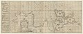 A chart of the sea coasts of England...and part of Barbary - btv1b53009614s.jpg 21,352 × 8,979; 27.58 MB
-

-

-

-

-
 Philipp Clüver, Mauritana et Africa Propria nunc Barbaria (FL13726071 2496059).jpg 3,834 × 3,380; 16.88 MB
-

-
 Wahrhaffte Abbildung der barbarischen Vestung Oran.jpg 14,240 × 12,254; 39.89 MB
-
 1736 Jaffa detail East Part of Barbary map by Herman Moll BPL 14639.png 1,260 × 464; 1.11 MB
-
 1736 Oran detail West Part of Barbary map by Herman Moll BPL 14639.png 1,245 × 473; 1.21 MB
-
 Several voyages to Barbary Fleuron T184089-19.png 3,425 × 2,194; 406 KB
-

-

-

-

-

-

-

-

-

-

-

-

-
-

-

-

-

-
 The Fortified City of Oran on the Barbary Coast.png 1,124 × 1,024; 2.29 MB
-

-

-

-

-

-
-
-
 EB1 Plate LXXXVIII.png 2,836 × 2,172; 3.36 MB
-
 Vüe de la ville de Sousse en Barbarie - btv1b53237553d (1 of 2).jpg 6,565 × 4,834; 4.83 MB
-
 Vüe de la ville et rade de Sousse en Barbarie - Le Moyne - btv1b53237552z (1 of 2).jpg 6,133 × 4,596; 4.29 MB
-
 Joseph Roux, Carte de la Mer Mediterranée (FL13733986 3373960).jpg 13,610 × 9,499; 177.08 MB
-

-
-

-
-

-

-
-

-

-
-

-
 Rigobert-Bonne-Atlas-de-toutes-les-parties-connues-du-globe-terrestre MG 0024.tif 5,334 × 3,618; 55.25 MB
-

-

-
 Le Coste di Barbaria (Antonio Zatta 1794, twelve small maps).jpg 556 × 379; 83 KB
-

-

-
 Côtes de Barbarie, depuis Bougie jusqu'à Bizerte - btv1b53237569h (1 of 2).jpg 10,146 × 3,838; 5.78 MB
-
 Les côtes de Barbarie - du cap Bon jusqu'à Bougie - btv1b53242275k (1 of 2).jpg 33,232 × 5,533; 21.15 MB
-
 Minute du plan d'Arzeu près d'Oran, côte de Barbarie - btv1b532423359 (1 of 2).jpg 11,944 × 6,712; 6.31 MB
-
-
 Plan des Albozènes dans le Royaume de Fez en Barbarie - btv1b59663963 (1 of 2).jpg 8,456 × 6,208; 4.97 MB
-
 Plan des Isles Zafarines a la coste de Barbarie - btv1b5966379k (1 of 2).jpg 4,544 × 5,928; 2.53 MB
-
 Plan des Isles Zafarines à la côte de Barbarie - btv1b59663785 (1 of 2).jpg 3,800 × 5,952; 2.19 MB
-

-

-
 Veue du Cap Nègre - situé à la côte de Barbarie Royaume de Thunis - btv1b53237537c (1 of 2).jpg 8,502 × 10,905; 11.97 MB
-
 Map of part of the Mediterranean Sea from Malaga to the Island of Minorca (1803).png 2,368 × 2,368; 5.82 MB
-
 1816 French map of the Barbary Coast.jpg 11,193 × 7,649; 19.19 MB
-

-
 (1817) MAP OF THE BARBARY STATE.jpg 3,131 × 2,371; 3.88 MB
-
-

-
 Carte Maghreb Vuillemin 1843.jpg 3,325 × 2,352; 3.37 MB
-

-

-
 1862 Johnson Map of Europe - Barbary Coast cutout.jpg 1,716 × 449; 278 KB
-

-
 Barbary coast3.jpg 974 × 582; 151 KB
-
-
 Barbary from Court Game of Geography MET DP862902.jpg 808 × 1,190; 336 KB
-

-

-

-
 Map of Barbary by Abraham Ortelius.jpeg 1,557 × 1,179; 546 KB
-

-

-
-

-
 Barbarie - 1806.jpg 3,000 × 2,400; 1.91 MB
.jpg)
.jpg)

_Novamente_il_Duca_di_Mendina_Celi_Vicere_di_Sicilia_con_l%27Armata_del_Re..._-_btv1b53196819t_(2_of_3).jpg)
.jpg)


.LU9.jpg)
_51.jpg)
,_ca._1600.jpg)

.jpg)
.jpg)
.jpg)
.jpg)


.jpg)
_-_par_Br%C3%A9mond_-_btv1b53028104r_(04_of_10).jpg)
.jpg)
.jpg)
.jpg)
.jpg)

.jpg)
.jpg)

.jpg)
,_1683.jpg)
.jpg)


.jpg)
.jpg)
.jpg)
.jpg)

.jpg)

_Henry_Michelot_-_btv1b5966376b_(1_of_2).jpg)
.jpg)
andem(en)t_de_Mrs_les_directeurs_g%C3%A9n%C3%A9raux_de_la_Compagnie_des_Indes_-_btv1b532375502_(1_of_2).jpg)

.jpg)
.jpg)


.jpg)
.jpg)


.jpg)
.jpg)
.jpg)
.jpg)


.jpg)
.jpg)
.jpg)
.jpg)
_et_les_Isles_Canaries,_seconde_feuille_Depuis..._-_btv1b10678512f_(1_of_2).jpg)


.jpg)
.jpg)
.jpg)
.jpg)


.jpg)
.jpg)
.jpg)


.jpg)

.jpg)
.jpg)
.jpg)
,_RP-P-1896-A-19368-3070.jpg)
.jpg)
.jpg)
.jpg)
.jpg)
.jpg)
.jpg)
.png)


_MAP_OF_THE_BARBARY_STATE.jpg)

.jpg)

.jpg)
_(14762849061).jpg)


_(cropped).jpg)

.jpg)
.jpg)
.jpg)
_-_btv1b53143340j.jpg)

.jpg)
.jpg)
.jpg)
.jpg)
.jpg)
.jpg)
.jpg)
.jpg)