Category:Maps of Bezirk Wiener Neustadt-Land
Wikimedia category | |||||
| Upload media | |||||
| Instance of | |||||
|---|---|---|---|---|---|
| Category combines topics | |||||
| Wiener Neustadt District | |||||
district of Austria   | |||||
| Instance of | |||||
| Named after | |||||
| Location | Lower Austria, Austria | ||||
| Capital | |||||
| Head of government |
| ||||
| Population |
| ||||
| Area |
| ||||
| Elevation above sea level |
| ||||
| official website | |||||
 | |||||
Subcategories
This category has only the following subcategory.
Media in category "Maps of Bezirk Wiener Neustadt-Land"
The following 13 files are in this category, out of 13 total.
-
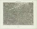
 Aufnahmeblatt 4855-2 Rohr im Gebirge, Hohenberg Kleinzell.jpg 10,243 × 7,395; 57.69 MB
-
 Aufnahmeblatt 4856-1b Weißenbach an der Triesting, Neuhaus.jpg 10,348 × 7,519; 45.35 MB
-
 Aufnahmeblatt 4856-1d Pernitz Hals Öd.jpg 10,362 × 7,456; 40.47 MB
-
 Aufnahmeblatt 4856-2 d Sollenau Felixdorf Großes und Kleines Mittel.jpg 10,379 × 7,475; 36.02 MB
-
 Aufnahmeblatt 4856-2a Pottenstein St. Veit Gainfarn.jpg 10,349 × 7,431; 42.74 MB
-
 Aufnahmeblatt 4856-2c Enzesfeld Hirtenberg Herrnstein Aigen.jpg 10,367 × 7,379; 41.68 MB
-
 Bezirk Wiener Neustadt Land Übersicht.PNG 370 × 360; 12 KB
-
 Bezirk Wiener Neustadt-Land in Österreich.png 692 × 359; 88 KB
-
 Josephinische Landesaufnahme Kirchschlag in der Buckligen Welt.JPEG 7,448 × 4,958; 16.2 MB
-
 Josephinische Landesaufnahme Wismath.JPEG 7,408 × 4,972; 16.92 MB
-
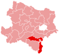 Karte Aut Noe WB.png 300 × 274; 5 KB
-
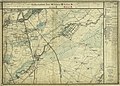
 Spezialkarte 4956 Neunkirchen und Aspang.jpg 7,259 × 5,642; 43.79 MB
-
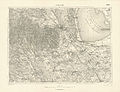 Spezialkarte 4957 Ödenburg.jpg 6,972 × 5,373; 26.09 MB


