Category:Maps of Boulogne-sur-Mer
Wikimedia category | |||||
| Upload media | |||||
| Instance of | |||||
|---|---|---|---|---|---|
| Category combines topics | |||||
| Boulogne-sur-Mer | |||||
French commune in Pas-de-Calais, Hauts-de-France   .svg)  | |||||
| Instance of | |||||
| Location | |||||
| Located in or next to body of water | |||||
| Head of government | |||||
| Has part(s) |
| ||||
| Significant event |
| ||||
| Population |
| ||||
| Area |
| ||||
| Elevation above sea level |
| ||||
| Different from | |||||
| official website | |||||
 | |||||
Subcategories
This category has only the following subcategory.
O
Media in category "Maps of Boulogne-sur-Mer"
The following 18 files are in this category, out of 18 total.
-
 62-AAV2020-Boulogne-sur-Mer.png 3,519 × 3,197; 2.77 MB
-
 62-Boulogne-sur-Mer-AAV2020.png 3,519 × 2,930; 1.82 MB
-
 62160-Boulogne-sur-Mer-Hydro.jpeg 5,846 × 4,133; 3.42 MB
-
 62160-Boulogne-sur-Mer-Sols.png 3,270 × 2,598; 4.69 MB
-
 62160-Boulogne-sur-Mer-ZNIEFF1.png 3,519 × 2,480; 7.48 MB
-
 62160-Boulogne-sur-Mer-ZNIEFF2.png 3,519 × 2,480; 7.34 MB
-
 Aireurbaineboulognesm.svg 3,489 × 2,329; 748 KB
-
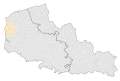
 Arrondissement boulogne pdc 62.png 527 × 238; 33 KB
-
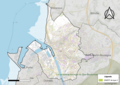
 Boulogne-sur-Mer OSM 01.png 992 × 834; 520 KB
-
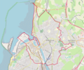
 Boulogne-sur-Mer OSM 02.png 992 × 834; 757 KB
-
 Boulogne-sur-Mer-Position.png 295 × 234; 24 KB
-

-
 Kaart 1814 - 2023 Echinghen.gif 1,000 × 737; 1.65 MB
-
 Lageskizze Gesoriacum.png 1,409 × 987; 340 KB
-
 Localisation de la Communauté d'Agglomération du Boulonnais.png 650 × 604; 73 KB
-
 Localisation de la Communauté d'agglomération du Boulonnais.svg 2,005 × 1,907; 116 KB
-
 Map commune FR insee code 62160.png 756 × 605; 56 KB
-
 Plan boulognesurmer.jpg 744 × 800; 204 KB


