Category:Maps of Ceylon by Petrus Plancius
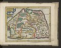
English: The Ceylon map by Petrus Plancius, created 1595(?), was included by Jodocus Hondius into the Mercator-Hondius Atlas.
Media in category "Maps of Ceylon by Petrus Plancius"
The following 12 files are in this category, out of 12 total.
-
 Laor Sri Lanka Map (Cropped).jpg 11,929 × 8,297; 29.55 MB
-
 Laor Sri Lanka Map.jpg 13,667 × 11,471; 19.89 MB
-
 Petrus Plancius, Ins. Ceilan, quæ incolís Tenarifin dicitur (FL35472039 2514032).jpg 13,667 × 11,471; 212.36 MB
-

-
 MercatormapTamilvannicountrynorthern.jpg 620 × 491; 149 KB
-
 Atlas Minor Gerardi Mercatoris 1609 (106758018).jpg 5,879 × 4,664; 5.79 MB
-
 Cosmographicae (10534353).jpg 11,949 × 8,181; 30.15 MB
-

-

-

-

-
 Atlas ou Representation du Monde Universel t. 2. 1633 (110103007).jpg 16,974 × 11,971; 33.68 MB
.jpg)

.jpg)
.jpg)

.jpg)
.jpg)
_-_btv1b53096740c_(537_of_603).jpg)
.jpg)
.jpg)
.jpg)
.jpg)