<nowiki>Category:Maps of County Sligo; categoría de Wikimedia; kategori Wikimedia; Wikimedia category; د ويکيمېډيا وېشنيزه; Vikimedya kategorisi; ویکیمیڈیا زمرہ; kategória projektov Wikimedia; категорія проєкту Вікімедіа; 维基媒体分类; Wikimedia-Kategorie; Викимедиина категорија; Wikimedia-Kategorie; विकिपीडिया:श्रेणी; page de catégorie de Wikimedia; kategorija na Wikimediji; विकिपीडिया वर्ग; категорија на Викимедији; Wikimedia-Kategorie; Wikimedia-kategori; kategori Wikimédia; تصنيف ويكيميديا; pajenn rummata eus Wikimedia; Wikimedia:ကဏ္ဍခွဲခြင်း; 維基媒體分類; Wikimedia категориясы; categoría de Wikimedia; Wikimedia-categorie; Wikimedia-Kategorie; tudalen categori Wikimedia; kategori e Wikimedias; Վիքիմեդիայի նախագծի կատեգորիա; 维基媒体分类; Wikimedia-kategori; ვიკიპედია:კატეგორიზაცია; ウィキメディアのカテゴリ; categoria Wikimedia; تصنيف بتاع ويكيميديا; විකිමීඩියා ප්රභේද පිටුව; categoria Vicimediorum; विकिमीडिया श्रेणी; Wikimedia-luokka; Wikimedia category; விக்கிமீடியப் பகுப்பு; катэгорыя ў праекце Вікімэдыя; Викимедиа проектындагы төркем; catigurìa di nu pruggettu Wikimedia; หน้าหมวดหมู่วิกิมีเดีย; Wikimedia:Kategorija; Wikimedia-Kategorie; Wikimedia:Klassys; категория на Уикимедия; categorie a unui proiect Wikimedia; categurìa 'e nu pruggette Wikimedia; Wikimedia-kategori; kawan Wikimèdia; 維基媒體分類; 위키미디어 분류; Wikimedia-bólkur; kategorio en Vikimedio; kategori Wikimedia; Wikimedia:Ronnaghys; উইকিমিডিয়া বিষয়শ্রেণী; kategori Wikimedia; 维基媒体分类; וויקימעדיע קאַטעגאָריע; kategorija w projektach Wikimedije; thể loại Wikimedia; Wikimedia projekta kategorija; Wikimedia-kategorie; categoria de um projeto da Wikimedia; 维基媒体分类; категорияд Ангилал; Wikimedia-kategori; kategori Wikimedia; پۆلی ویکیمیدیا; Wikimedia category; Vikimédia ñemohenda; Wikimédia-kategória; વિકિપીડિયા શ્રેણી; Wikimediako kategoria; категория в проекте Викимедиа; Wikimedia-Kategorie; катэгорыя ў праекце Вікімедыя; Wikimedia-kategorie; Wîkîmediya:Kategorî; विकिमिडिया श्रेणी; Wikimedia-Kategorie; קטגוריה במיזמי ויקימדיה; Викимедиа проектындагы төркем; Wikimedia-categorie; विकिमिडिया श्रेणी; κατηγορία εγχειρημάτων Wikimedia; Wikimedia-kategoriija; гурӯҳи Викимедиа; 維基媒體分類; Wikimedia-categorie; categoría de Wikimedia; categoria di un progetto Wikimedia; Wikimedia-kategory; Wikimedia category; jamii ya Wikimedia; Wikimedia kategooria; Wikimedia-Kategorie; 維基媒體分類; ردهٔ ویکیپدیا; categoria de Wikimedia; ẹ̀ka Wikimedia; kategorya ng Wikimedia; categoria de um projeto da Wikimedia; гурӯҳи Викимедиа; kategorie na projektech Wikimedia; tumbung Wikimedia; kategorija na Wikimediji; kategorija Wikimedie; Wikimedia proyektındağı törkem; Викимедиа категорияһы; kategoria ti Wikimedia; kategori Wikimedia; kategoria w projekcie Wikimedia; വിക്കിമീഡിയ വർഗ്ഗം; 維基媒體分類; kategori Wikimedia; Kategoriya ning Wikimedia; زمرو:وڪيپيڊيا زمرا بندي; Viciméid catagóir; categoría de Wikimedia; Vikipidiya:Shopni; 维基媒体分类; guruhi Vikimedia</nowiki>
Subcategories
This category has only the following subcategory.


 The Counties of Sligoe and Mayo - By H. Moll Geographer - btv1b530561688.jpg 3,424 × 2,768; 1.65 MB


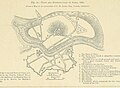
 Admiralty Chart No 2767 Sligo and Killala Bays, Published 1860.jpg 16,283 × 11,264; 26.93 MB
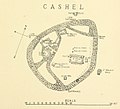
 Ballymote Map.png 1,000 × 711; 135 KB
 Ballymote Map.svg 744 × 1,052; 448 KB
 Baronies of Sligo.jpg 3,142 × 2,227; 1.48 MB
 Barony of Carbury, County Sligo.png 360 × 326; 6 KB
 Barony of Coolavin, Co. Sligo.png 360 × 326; 6 KB
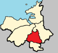 Barony of Corran, Co. Sligo.png 360 × 326; 6 KB
 Barony of Leyny, Co. Sligo.png 360 × 326; 6 KB
 Barony of Tireragh, Co. Sligo.png 360 × 326; 6 KB
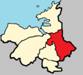 Barony of Tirerril, Co. Sligo.png 360 × 326; 6 KB
 Ireland map County Sligo Magnified.png 188 × 244; 8 KB
 IrelandSligo.png 200 × 249; 30 KB
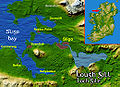 Loughgillsatmap.jpg 518 × 374; 298 KB
 Sligo - British Isles.svg 1,250 × 1,835; 1,002 KB
 Sligo Ireland (BI Sect 7).svg 583 × 711; 1,004 KB
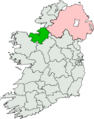 Sligo-North Leitrim (Dáil Éireann constituency).png 2,294 × 2,910; 69 KB
._With_illustrations,_etc%27_(11155123714).jpg)


._With_illustrations,_etc%27_(11279242266).jpg)
._With_illustrations,_etc%27_(11282104666).jpg)
._With_illustrations,_etc%27_(11084510666).jpg)
._With_illustrations,_etc%27_(11153965674).jpg)


.jpg)

.svg)
.png)