Category:Maps of Cumberland County, New Jersey
Wikimedia category | |||||
| Upload media | |||||
| Instance of | |||||
|---|---|---|---|---|---|
| Category combines topics | |||||
| Cumberland County | |||||
county in New Jersey, United States    | |||||
| Instance of | |||||
| Named after | |||||
| Location | New Jersey | ||||
| Capital | |||||
| Inception |
| ||||
| Population |
| ||||
| Area |
| ||||
| Different from | |||||
| official website | |||||
 | |||||
Subcategories
This category has the following 3 subcategories, out of 3 total.
Media in category "Maps of Cumberland County, New Jersey"
The following 25 files are in this category, out of 25 total.
-
 Admiralty Chart No 2564 Delaware River from Cohansey to Philadelphia, Published 1858.jpg 8,153 × 12,023; 8.49 MB
-
 Cedarville cdp nj 011.png 600 × 580; 53 KB
-
 Census Bureau map of Commercial Township, New Jersey.png 575 × 425; 37 KB
-
 Census Bureau map of Shiloh, New Jersey.png 575 × 425; 21 KB
-
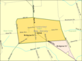
 Census Bureau map of Upper Deerfield Township, New Jersey.png 575 × 425; 51 KB
-

-
-

-

-

-

-

-

-

-

-
 Fairton cdp nj 011.png 600 × 580; 53 KB
-
 Laurel lake cdp nj 011.png 600 × 580; 53 KB
-
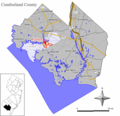
 Location map of Cumberland County, New Jersey.svg 896 × 768; 1.08 MB
-
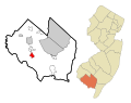
 Map of New Jersey highlighting Cumberland County.svg 1,426 × 2,700; 61 KB
-
 Map of the settled parts of the Vineland tract LOC 2012593524.jpg 13,383 × 11,281; 23.24 MB
-
 New Jersey Coastal Heritage Trail, Delsea region LOC 96687583.jpg 4,289 × 5,250; 3.46 MB
-
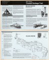 New Jersey Coastal Heritage Trail, Delsea region LOC 96687583.tif 4,289 × 5,250; 64.42 MB
-
 Port norris cdp nj 011.png 600 × 580; 53 KB
-
 Rosenhayn cdp nj 011.png 600 × 580; 54 KB
-
 Seabrook farms cdp nj 011.png 600 × 580; 53 KB


