Category:Maps of Gaillagos
Wikimedia category | |||||
| Upload media | |||||
| Instance of | |||||
|---|---|---|---|---|---|
| Category combines topics | |||||
| Gaillagos | |||||
commune in Hautes-Pyrénées, France _1.jpg) .svg)  | |||||
| Instance of | |||||
| Location |
| ||||
| Population |
| ||||
| Area |
| ||||
| Elevation above sea level |
| ||||
 | |||||
Subcategories
This category has the following 3 subcategories, out of 3 total.
E
- Ecological maps of Gaillagos (3 F)
T
Media in category "Maps of Gaillagos"
The following 8 files are in this category, out of 8 total.
-
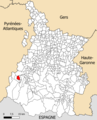 65182-Gaillagos - Localisation.png 2,000 × 2,480; 1.04 MB
-
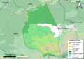
 65182-Gaillagos-argile.jpg 3,057 × 2,480; 594 KB
-
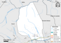
 65182-Gaillagos-Cadastre.png 7,015 × 4,960; 4.47 MB
-
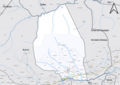
 65182-Gaillagos-Hydro.png 7,015 × 4,960; 2.75 MB
-
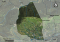 65182-Gaillagos-Orthophoto.png 7,015 × 4,960; 8.82 MB
-
 65182-Gaillagos-Sols.png 7,015 × 4,960; 3.04 MB
-
 Localisation de Gaillagos dans les Hautes-Pyrénées 1.pdf 1,754 × 2,481; 617 KB
-
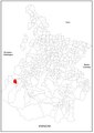
 Map commune FR insee code 65182.png 756 × 605; 37 KB


