Category:Maps of Harlingen (municipality)
Wikimedia category | |||||
| Upload media | |||||
| Instance of | |||||
|---|---|---|---|---|---|
| Category combines topics | |||||
| Harlingen | |||||
municipality in Friesland, the Netherlands      | |||||
| Pronunciation audio | |||||
| Instance of |
| ||||
| Named after | |||||
| Location | Friesland, Netherlands | ||||
| Capital | |||||
| Population |
| ||||
| Area |
| ||||
| official website | |||||
 | |||||
Subcategories
This category has the following 2 subcategories, out of 2 total.
Media in category "Maps of Harlingen (municipality)"
The following 12 files are in this category, out of 12 total.
-
 2013-Harlingen.jpg 4,198 × 3,770; 3.78 MB
-
 BAG woonplaatsen - Gemeente Harlingen.png 2,419 × 2,419; 563 KB
-
 Gem-Harlingen-2014Q1.jpg 8,673 × 8,758; 11.39 MB
-
 Gem-Harlingen-OpenTopo.jpg 4,513 × 5,146; 3.02 MB
-
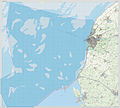
 Harlingen location map municipality NL 2018.png 760 × 598; 93 KB
-
 Map - NL - Harlingen (2009).svg 625 × 575; 1.46 MB
-
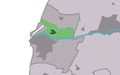
 Map NL Harns Harns.png 800 × 500; 24 KB
-
 Map NL Harns Mullum.png 800 × 500; 23 KB
-
 Map NL Harns Winaam.png 800 × 500; 23 KB
-
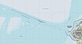 Pollendam.jpg 2,533 × 1,355; 164 KB
-
 Regels Barradeel noord.png 1,017 × 1,125; 2.25 MB
-
 Regels Barradeel zuid Wonsdl.png 1,346 × 1,110; 3.71 MB


.svg)


