Category:Maps of Kankakee County, Illinois (dot)
Media in category "Maps of Kankakee County, Illinois (dot)"
The following 14 files are in this category, out of 14 total.
-
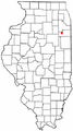
 ILMap-doton-AromaPark.PNG 167 × 300; 24 KB
-
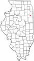
 ILMap-doton-Bonfield.PNG 167 × 300; 24 KB
-
 ILMap-doton-Bourbonnais.PNG 167 × 300; 24 KB
-
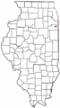
 ILMap-doton-Buckingham.PNG 167 × 300; 24 KB
-
 ILMap-doton-Cabery.PNG 167 × 300; 24 KB
-
 ILMap-doton-Chebanse.PNG 167 × 300; 24 KB
-
 ILMap-doton-Essex.PNG 167 × 300; 24 KB
-
 ILMap-doton-GrantPark.PNG 167 × 300; 24 KB
-
 ILMap-doton-Herscher.PNG 167 × 300; 24 KB
-
 ILMap-doton-HopkinsPark.PNG 167 × 300; 24 KB
-
 ILMap-doton-Irwin.PNG 167 × 300; 24 KB
-
 ILMap-doton-Kankakee.png 167 × 300; 24 KB
-
 ILMap-doton-Manteno.PNG 167 × 300; 24 KB
-
 ILMap-doton-Momence.PNG 167 × 300; 24 KB


