<nowiki>Category:Maps of Kasaragod district; categoría de Wikimedia; kategori Wikimedia; Wikimedia category; د ويکيمېډيا وېشنيزه; Vikimedya kategorisi; ویکیمیڈیا زمرہ; kategória projektov Wikimedia; категорія проєкту Вікімедіа; 维基媒体分类; Wikimedia-Kategorie; kategorie na projektech Wikimedia; Wikimedia-Kategorie; विकिपीडिया:श्रेणी; page de catégorie de Wikimedia; kategorija na Wikimediji; विकिपीडिया वर्ग; категорија на Викимедији; Wikimedia-Kategorie; Wikimedia-kategori; kategori Wikimédia; تصنيف ويكيميديا; pajenn rummata eus Wikimedia; Wikimedia:ကဏ္ဍခွဲခြင်း; 維基媒體分類; Wikimedia категориясы; categoría de Wikimedia; Wikimedia-Kategorie; Wikimedia-Kategorie; tudalen categori Wikimedia; kategori e Wikimedias; Վիքիմեդիայի նախագծի կատեգորիա; 维基媒体分类; Wikimedia-kategory; ვიკიპედია:კატეგორიზაცია; ウィキメディアのカテゴリ; categoria Wikimedia; تصنيف بتاع ويكيميديا; විකිමීඩියා ප්රභේද පිටුව; categoria Vicimediorum; विकिमीडिया श्रेणी; Wikimedia-luokka; Wikimedia-categorie; விக்கிமீடியப் பகுப்பு; катэгорыя ў праекце Вікімэдыя; Викимедиа проектындагы төркем; catigurìa di nu pruggettu Wikimedia; หน้าหมวดหมู่วิกิมีเดีย; Wikimedia:Kategorija; Wikimedia-Kategorie; Wikimedia:Klassys; категория на Уикимедия; categorie a unui proiect Wikimedia; 維基媒體分類; Wikimedia-kategori; kawan Wikimèdia; гурӯҳи Викимедиа; 위키미디어 분류; Wikimedia-bólkur; kategorio en Vikimedio; kategori Wikimedia; categoría de Wikimedia; উইকিমিডিয়া বিষয়শ্রেণী; kategori Wikimedia; 维基媒体分类; וויקימעדיע קאַטעגאָריע; kategorija w projektach Wikimedije; thể loại Wikimedia; Wikimedia projekta kategorija; Wikimedia-kategorie; categoria de um projeto da Wikimedia; 维基媒体分类; категорияд Ангилал; Wikimedia-kategori; kategori Wikimedia; پۆلی ویکیمیدیا; Wikimedia category; Vikimédia ñemohenda; Wikimédia-kategória; વિકિપીડિયા શ્રેણી; Wikimediako kategoria; категория в проекте Викимедиа; Wikimedia-Kategorie; катэгорыя ў праекце Вікімедыя; Wikimedia-kategorie; Wîkîmediya:Kategorî; विकिमिडिया श्रेणी; Wikimedia-Kategorie; קטגוריה במיזמי ויקימדיה; Викимедиа проектындагы төркем; 维基媒体分类; विकिमिडिया श्रेणी; 維基媒體分類; Wikimedia-kategoriija; гурӯҳи Викимедиа; kategoria w projekcie Wikimedia; Wikimedia:Ronnaghys; Wikimedia-categorie; categoria di un progetto Wikimedia; categoria de Wikimedia; Wikimedia category; categurìa 'e nu pruggette Wikimedia; 維基媒體分類; Wikimedia category; Wikimedia-kategori; kategorya ng Wikimedia; 維基媒體分類; ẹ̀ka Wikimedia; Викимедиина категорија; categoria de um projeto da Wikimedia; kategorija na Wikimediji; ردهٔ ویکیپدیا; tumbung Wikimedia; kategoria ti Wikimedia; kategorija Wikimedije; Wikimedia proyektındağı törkem; Vikipidiya:Shopni; Викимедиа категорияһы; kategori Wikimedia; jamii ya Wikimedia; വിക്കിമീഡിയ വർഗ്ഗം; Wikimedia-categorie; kategori Wikimedia; Kategoriya ning Wikimedia; زمرو:وڪيپيڊيا زمرا بندي; Viciméid catagóir; categoría de Wikimedia; Wikimedia kategooria; κατηγορία εγχειρημάτων Wikimedia; guruhi Vikimedia</nowiki>
Subcategories
This category has the following 3 subcategories, out of 3 total.


 01-kasaragod.png 749 × 1,032; 83 KB
 01-kasaragod.svg 744 × 1,052; 30 KB
 BlankMapKasaragodSubdistricts.svg 601 × 766; 21 KB
 Hosdurg-thaluk.png 5,879 × 7,942; 2.47 MB
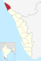 India Kerala Kasaragod district.svg 874 × 1,274; 539 KB
 Kanhangad.svg 1,164 × 778; 1.4 MB
 KanhangadLSGI.svg 775 × 1,038; 1.27 MB
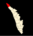 Kasaragod district location map.svg 700 × 766; 1.72 MB
 Kasaragod district.png 2,000 × 2,428; 828 KB
 Kasaragod-map-en.png 1,909 × 2,758; 501 KB
 Kasaragod-map-en.svg 1,909 × 2,758; 215 KB
 Kasaragod-map.png 1,909 × 2,758; 590 KB
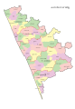 Kasaragod-map.svg 1,909 × 2,758; 647 KB
 Kasaragod-thaluk.png 5,879 × 7,942; 2.47 MB
 Local Self Governance in Kasaragod District.svg 1,041 × 1,533; 13.94 MB
 Location of Kasaragod Kerala.png 251 × 420; 9 KB
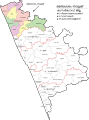 Manjeswara Taluk-ml.png 5,879 × 7,942; 2.46 MB
 Map of Mogral Puthur.jpg 422 × 384; 36 KB
 Map-Kasaragod.svg 744 × 900; 676 KB
 Subdistricts of Kasaragod.png 477 × 642; 71 KB
 Vellarikundu Taluk.png 5,927 × 7,942; 2.47 MB


