Category:Maps of Kolsky Uyezd
Media in category "Maps of Kolsky Uyezd"
The following 8 files are in this category, out of 8 total.
-
 AUBEL(1874) p439 Übersichtskarte von Lappland und Kanin.jpg 3,793 × 3,277; 5.62 MB
-
 Acta Soc. pro Fauna et Flora Fennica (1889-1890) (16564654597).jpg 2,072 × 1,740; 870 KB
-
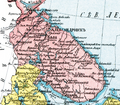 Map of Alexandrovsky Uyezd (1913).png 2,097 × 1,833; 5.9 MB
-
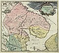
 Russian Empire 1745 (Map I HQ).jpg 8,986 × 8,056; 9.36 MB
-
 Russian Empire 1745 (Map I in Latin).jpg 7,568 × 6,658; 15.98 MB
-
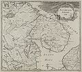 Russian Empire 1745 (Map I).jpg 2,124 × 1,872; 2.43 MB
-
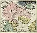
 Russian-Lapland-1745.jpg 2,127 × 1,860; 599 KB
-
 Лапландия.jpg 17,972 × 16,112; 51.15 MB
_p439_%C3%9Cbersichtskarte_von_Lappland_und_Kanin.jpg)
_(16564654597).jpg)
.png)
.jpg)
.jpg)
.jpg)

