Category:Maps of London, Ontario
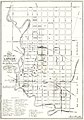
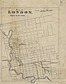
Hand-drawn, colour map of London Ontario with inset drawings of the building fronts of local companies.  | |||||
| Upload media | |||||
| Instance of |
| ||||
|---|---|---|---|---|---|
| Depicts | business, London and building | ||||
| Location | London, Middlesex County, Ontario, Canada | ||||
| Publisher |
| ||||
| Place of publication | |||||
| Language of work or name | |||||
| Inception |
| ||||
| Width |
| ||||
| Height |
| ||||
| official website | |||||
 | |||||
Pages in category "Maps of London, Ontario"
This category contains only the following page.
Media in category "Maps of London, Ontario"
The following 48 files are in this category, out of 48 total.
-
 Bell Telephone Coy's property, London, Ont.jpg 1,600 × 975; 109 KB
-
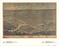 Bird's Eye View of London, Ontario, Canada, 1872.jpg 1,600 × 1,270; 512 KB
-
 Birds Eye View of the Site of the Forks of the Thames with . . . 1793 (I0041624).jpg 2,284 × 1,033; 2.85 MB
-
 Birds Eye View of the Site of the Forks of the Thames with . . . 1793 (I0041624).tif 2,284 × 1,033; 6.77 MB
-
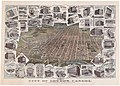 City of London, Canada, With Views of Principal Business Buildings.jpg 1,600 × 1,148; 644 KB
-
 City of London, Ont. Canada.jpg 1,600 × 862; 462 KB
-

-
 Crown Lands Dept Plan of London.jpg 1,594 × 1,600; 320 KB
-
 Elgin-Middlesex-London.png 682 × 858; 81 KB
-
 Features of North Central London in the 1840s.jpg 1,600 × 1,196; 331 KB
-
 Lines of the London Street Ry Co., London, Ont., 1909.jpg 1,600 × 960; 211 KB
-

-
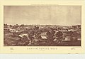
 London C.W. Sketch of Country.jpg 1,302 × 1,600; 445 KB
-
 London CW.jpg 1,600 × 1,044; 250 KB
-
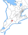
 London ontario ward map 2018.png 571 × 551; 14 KB
-
 London, Canada West, 1840-1841.jpg 1,600 × 1,287; 493 KB
-
 London, Canada West.jpg 1,600 × 1,109; 353 KB
-
 London-fanshawe.PNG 682 × 858; 81 KB
-
 Londonnorthcentre-swontario.PNG 682 × 858; 81 KB
-
 Lorne Heights London Ontario.jpg 1,600 × 1,155; 331 KB
-
 Map of Kensal Park, London, Ontario.jpg 1,600 × 1,233; 427 KB
-
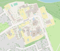 Map of Kings University College.svg 1,081 × 916; 1.02 MB
-
 Map of the city of London and suburbs.jpg 1,600 × 1,419; 520 KB
-
 Map of the City of London and Suburbs.jpg 1,600 × 1,171; 365 KB
-
 Map of the City of London Canada West.jpg 1,053 × 1,600; 308 KB
-
-

-
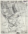
 Map of the Township of London, Canada West, 1863.jpg 1,243 × 1,600; 505 KB
-
 Onmsxlondon.PNG 396 × 566; 17 KB
-

-
 Plan (in pencil) of property in the Village of Petersville.jpg 1,600 × 1,368; 249 KB
-
-
 Plan of laying out the ground of Publick Square, London.jpg 971 × 1,600; 244 KB
-
 Plan of London shewing the gas lamps.jpg 1,254 × 1,600; 406 KB
-
 Plan of London, Middlesex County, Ontario.jpg 1,265 × 1,600; 429 KB
-
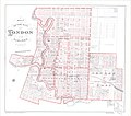
 Plan of London.jpg 1,349 × 1,600; 404 KB
-

-
 Plan of St. Paul's Cemetery, London Canada West.jpg 1,340 × 1,600; 229 KB
-
 Plan of the City of London Ontario, A.D. 1871.jpg 1,600 × 1,552; 439 KB
-
 Plan of the Town of London, CW, Published by The Craig, London, 1846.jpg 1,228 × 1,600; 353 KB
-
 Plan of Woodside Survey, London South, Property of Charles Hutchinson, Esq're.jpg 1,600 × 1,213; 347 KB
-
 Proposed Route of the West Ontario Pacific Railroad through the City of London.jpg 1,219 × 1,600; 405 KB
-
 School Reserve in the Broken Front of Westminster.jpg 1,600 × 867; 226 KB
-
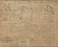
 Sketch of part of the London Township.jpg 1,525 × 1,600; 562 KB
-

-
 Sketch of the position of London, U.C. Nov'r 1839.jpg 1,600 × 1,179; 268 KB
-

-
 The Site of London.jpg 1,600 × 1,285; 182 KB


.jpg)


_of_property_in_the_Village_of_Petersville.jpg)


_the_site_for_the_City_of_London,_1816.jpg)


