Category:Maps of McLean County, North Dakota
Wikimedia category | |||||
| Upload media | |||||
| Instance of | |||||
|---|---|---|---|---|---|
| Category combines topics | |||||
| McLean County | |||||
county in North Dakota, United States   | |||||
| Instance of | |||||
| Location | North Dakota | ||||
| Capital | |||||
| Inception |
| ||||
| Population |
| ||||
| Area |
| ||||
| Different from | |||||
| official website | |||||
 | |||||
Media in category "Maps of McLean County, North Dakota"
The following 22 files are in this category, out of 22 total.
-
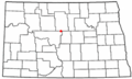
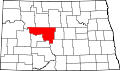 Map of North Dakota highlighting McLean County.svg 5,804 × 3,456; 56 KB
-
 ND McLean County Benedict.svg 990 × 765; 440 KB
-
 ND McLean County Butte.svg 990 × 765; 440 KB
-
 ND McLean County Coleharbor.svg 990 × 765; 440 KB
-
 ND McLean County Garrison.svg 990 × 765; 441 KB
-
 ND McLean County Max.svg 990 × 765; 441 KB
-
 ND McLean County Mercer.svg 990 × 765; 440 KB
-
 ND McLean County Riverdale.svg 990 × 765; 441 KB
-
 ND McLean County Ruso.svg 990 × 765; 440 KB
-
 ND McLean County Turtle Lake.svg 990 × 765; 441 KB
-
 ND McLean County Underwood.svg 990 × 765; 441 KB
-
 ND McLean County Washburn.svg 990 × 765; 441 KB
-
 ND McLean County White Shield.svg 990 × 765; 435 KB
-
 ND McLean County Wilton.svg 990 × 765; 441 KB
-
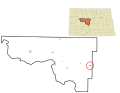
 NDMap-doton-Butte.PNG 300 × 179; 11 KB
-
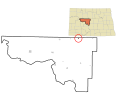
 NDMap-doton-Garrison.PNG 300 × 179; 11 KB
-
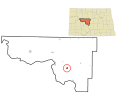
 NDMap-doton-Max.PNG 300 × 179; 11 KB
-
 NDMap-doton-Mercer.PNG 300 × 179; 11 KB
-
 NDMap-doton-Riverdale.PNG 300 × 179; 11 KB
-
 NDMap-doton-TurtleLake.PNG 300 × 179; 11 KB
-
 NDMap-doton-Underwood.PNG 300 × 179; 11 KB
-
 NDMap-doton-WhiteShield.PNG 300 × 179; 11 KB


