Category:Maps of Moore County, North Carolina
Counties of North Carolina: Alamance · Alexander · Alleghany · Anson · Ashe · Avery · Beaufort · Bertie · Bladen · Brunswick · Buncombe · Burke · Cabarrus · Caldwell · Camden · Carteret · Caswell · Catawba · Chatham · Cherokee · Chowan · Clay · Cleveland · Columbus · Craven · Cumberland · Currituck · Dare · Davidson · Davie · Duplin · Durham · Edgecombe · Forsyth · Franklin · Gaston · Gates · Graham · Granville · Greene · Guilford · Halifax · Harnett · Haywood · Henderson · Hertford · Hoke · Hyde · Iredell · Jackson · Johnston · Jones · Lee · Lenoir · Lincoln · Macon · Madison · Martin · McDowell · Mecklenburg · Mitchell · Montgomery · Moore · Nash · New Hanover · Northampton · Onslow · Orange · Pamlico · Pasquotank · Pender · Perquimans · Person · Pitt · Polk · Randolph · Richmond · Robeson · Rockingham · Rowan · Rutherford · Sampson · Scotland · Stanly · Stokes · Surry · Swain · Transylvania · Tyrrell · Union · Vance · Wake · Warren · Washington · Watauga · Wayne · Wilkes · Wilson · Yadkin · Yancey
Wikimedia category | |||||
| Upload media | |||||
| Instance of | |||||
|---|---|---|---|---|---|
| Category combines topics | |||||
| Moore County | |||||
county in North Carolina, United States   | |||||
| Instance of | |||||
| Named after |
| ||||
| Location | North Carolina | ||||
| Capital | |||||
| Inception |
| ||||
| Population |
| ||||
| Area |
| ||||
| Different from | |||||
| official website | |||||
 | |||||
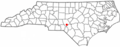
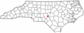
Moore County is located in North Carolina in the United States. Its county seat is Carthage.
Media in category "Maps of Moore County, North Carolina"
The following 27 files are in this category, out of 27 total.
-
-
 Map of North Carolina highlighting Moore County.svg 8,061 × 3,056; 236 KB
-
-

-

-

-

-

-

-
-

-

-

-
-
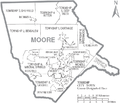
 Moore County North Carolina incorporated and unincorporated areas.svg 835 × 741; 7.51 MB
-
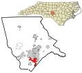
 NCMap-doton-Aberdeen.PNG 300 × 117; 9 KB
-
 NCMap-doton-Cameron.PNG 300 × 117; 9 KB
-
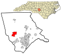
 NCMap-doton-Carthage.PNG 300 × 117; 9 KB
-
 NCMap-doton-Foxfire.PNG 300 × 117; 9 KB
-
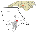
 NCMap-doton-Pinebluff.PNG 300 × 117; 9 KB
-
 NCMap-doton-Robbins.PNG 300 × 117; 9 KB
-
 NCMap-doton-SevenLakes.PNG 300 × 117; 9 KB
-
 NCMap-doton-Taylortown.PNG 300 × 117; 9 KB
-
 NCMap-doton-Vass.PNG 300 × 117; 9 KB
-
 NCMap-doton-WhisperingPines.PNG 300 × 117; 9 KB
-
 North Carolina Map Highlighting Moore County.PNG 531 × 201; 15 KB
-
 Research Triangle 2013.png 654 × 266; 47 KB


