Category:Maps of Passaic County, New Jersey
Wikimedia category | |||||
| Upload media | |||||
| Instance of | |||||
|---|---|---|---|---|---|
| Category combines topics | |||||
| Passaic County | |||||
county in New Jersey, United States    | |||||
| Instance of | |||||
| Location | New Jersey | ||||
| Capital | |||||
| Inception |
| ||||
| Population |
| ||||
| Area |
| ||||
| Different from | |||||
| official website | |||||
 | |||||
Subcategories
This category has the following 3 subcategories, out of 3 total.
L
Media in category "Maps of Passaic County, New Jersey"
The following 42 files are in this category, out of 42 total.
-
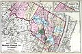
 AcquackanonkTownshipNewJersey1872.JPG 500 × 700; 120 KB
-
 Bergen Passaic 1872.jpg 3,491 × 2,325; 1.48 MB
-
 Census Bureau map of Bloomingdale, New Jersey.png 575 × 425; 56 KB
-
 Census Bureau map of Haledon, New Jersey.png 575 × 425; 56 KB
-
 Census Bureau map of Hawthorne, New Jersey.png 575 × 425; 73 KB
-
 Census Bureau map of Little Falls, New Jersey.png 575 × 425; 76 KB
-
 Census Bureau map of North Haledon, New Jersey.png 575 × 425; 69 KB
-
 Census Bureau map of Pompton Lakes, New Jersey.png 575 × 425; 70 KB
-
 Census Bureau map of Prospect Park, New Jersey.png 575 × 425; 59 KB
-
 Census Bureau map of Ringwood, New Jersey.png 575 × 425; 65 KB
-
 Census Bureau map of Totowa, New Jersey.png 575 × 425; 80 KB
-
 Census Bureau map of Wanaque, New Jersey.png 575 × 425; 58 KB
-
 Census Bureau map of Wayne, New Jersey.png 575 × 425; 76 KB
-
 Census Bureau map of West Milford, New Jersey.png 575 × 425; 67 KB
-
 Census Bureau map of West Paterson, New Jersey.png 575 × 425; 78 KB
-

-
 Great Notch station map.PNG 986 × 600; 87 KB
-
 Location map of Passaic County, New Jersey.svg 896 × 768; 418 KB
-
 Map of New Jersey highlighting Passaic County.svg 1,426 × 2,700; 61 KB
-
 Passaic County most spoken language at home map 2015.svg 373 × 427; 23 KB
-

-

-
-
-
-

-

-

-
-

-
-

-

-

-
 Passaic County racial and ethnic map 2010.svg 373 × 427; 23 KB
-
 Passaic County, NJ municipalities labeled.png 2,048 × 2,896; 330 KB
-
 Passaic County, NJ municipalities labeled.svg 512 × 650; 123 KB
-
 Table of Contents. NYPL1602552.tiff 5,360 × 6,962; 106.77 MB
-
 Table of Distances from one Village to another, in Passaic County, N.J. NYPL1602527.tiff 6,972 × 5,422; 108.15 MB
-

-
 The Business Representation of Paterson and Passaic County. Patrons of this Atlas. NYPL1602560.tiff 5,392 × 6,970; 107.53 MB
-
 Township of West Milford (Township) NYPL1602559.tiff 7,190 × 4,886; 100.51 MB


.png)


