Category:Maps of Somali Civil War
See also : Category:Conflicts by country
| Ongoing armed conflicts ( Countries Maps ) |
|---|
|
National or regional Maps of ongoing insurgencies, armed conflicts, disputes of territories, military conflicts, and also current civil or international wars :
See also:
Category:Conflicts in 2024 (with list of countries in ongoing armed conflicts) Template:City maps of ongoing civil wars (Local maps) |


.svg)

.png)


.svg)


.svg)


| Ongoing armed conflicts ( Local & City Maps ) |
|---|
|
Local or city Maps of ongoing insurgencies, armed conflicts, disputes of territories, military conflicts, and also current civil or international wars :
|

_Territory_Change_2014-2016.gif)

_(within_Northern_Syria).svg)


.png)
.svg)


_map.png)
.svg)


.svg)


Wikimedia category | |||||
| Upload media | |||||
| Instance of | |||||
|---|---|---|---|---|---|
| Category combines topics | |||||
| Somali Civil War | |||||
civil war taking place in Somalia since 1991  | |||||
| Instance of | |||||
| Part of |
| ||||
| Location | Somalia | ||||
| Start time |
| ||||
| |||||
Subcategories
This category has the following 6 subcategories, out of 6 total.
M
- Maps of Galmudug (11 F)
- Maps of Jubaland (11 F)
- Maps of Northland (1 F)
- Maps of Ximan & Xeeb (1 F)
Media in category "Maps of Somali Civil War"
The following 131 files are in this category, out of 131 total.
-
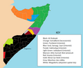
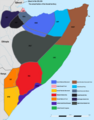
 !Somali Civil War (2009-present).png 3,149 × 3,996; 1.07 MB
-
 2006 ICU ar.svg 235 × 303; 11 KB
-
 2006 ICU-es.svg 349 × 320; 17 KB
-
 2006 ICU.png 250 × 324; 10 KB
-
 2006 ICU.svg 235 × 303; 61 KB
-
 2012 somaliland and puntland.jpg 1,548 × 1,236; 505 KB
-
 Battle of mogadishu map of city.png 1,312 × 1,886; 1.55 MB
-
 Battle-of-baidoa-12262006-0752-ar.png 1,218 × 704; 310 KB
-
 Battle-of-baidoa-12262006-0752.svg 1,163 × 704; 549 KB
-
 Battle-of-bandiradley-12262006.svg 543 × 355; 252 KB
-
 Battle-of-beledweyne-12312006-1930.svg 424 × 634; 231 KB
-
 Battle-of-jilib-12312006-1404.svg 557 × 464; 188 KB
-
 Battle-of-ras-kamboni-01122007-1302.svg 489 × 713; 232 KB
-
 Divisão da Somália.PNG 1,249 × 324; 56 KB
-
 Ethiopian Operations.png 512 × 641; 18 KB
-
 Fedmap2.png 779 × 640; 34 KB
-
 Fedmap4.png 779 × 640; 45 KB
-
 Fedmapnew.png 779 × 640; 38 KB
-
 Fedmapsom.png 779 × 640; 36 KB
-
 Galmudug map.png 646 × 572; 32 KB
-
 HSM map.png 1,023 × 641; 33 KB
-
 Icu somalia map.png 2,400 × 3,112; 303 KB
-
 Isaaq genocide map.png 2,514 × 3,588; 432 KB
-
 Karte Operation Southern Cross.svg 622 × 604; 2.02 MB
-
 Location federal.png 250 × 325; 18 KB
-
 Location galmudug.png 250 × 325; 17 KB
-
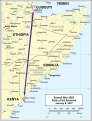
 Location jubaland.png 797 × 710; 109 KB
-
 Location jubbaland.png 405 × 432; 6 KB
-
 Location maakhir.png 250 × 325; 17 KB
-
 Location northland.png 250 × 325; 17 KB
-
 Location Puntland and Maakhir.png 250 × 325; 15 KB
-
 Location puntland.png 250 × 325; 18 KB
-
 Location somaliland.png 250 × 325; 19 KB
-
 Location southwestern.png 250 × 324; 9 KB
-
 Location ximan & xeeb.png 250 × 325; 15 KB
-
 LocationGalmudug.PNG 250 × 115; 5 KB
-
 LocationGalmudug2.png 250 × 115; 4 KB
-
 LocationPuntland.png 250 × 115; 7 KB
-
 LocationPuntland2.png 250 × 115; 4 KB
-
 LocationSomalia2.png 250 × 115; 4 KB
-
 LocationSomaliland.png 250 × 115; 7 KB
-
 LocationSSC.png 798 × 398; 95 KB
-
 Lower-juba-12292006-1627.svg 524 × 571; 336 KB
-
 Maakhir map.png 476 × 466; 75 KB
-
 Maakhirgeo.png 330 × 355; 15 KB
-
 Map of Jubaland.png 1,328 × 2,694; 7.36 MB
-
 Map of somaliland border claims.jpg 590 × 504; 118 KB
-
 Mogadishu nov 26 01.png 771 × 552; 60 KB
-
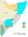
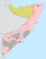
 Political situation in Somalia following the Ethiopian withdrawal.png 2,000 × 2,594; 989 KB
-
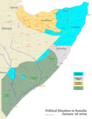
 Political Situation of Somalia on August 4, 2012.png 570 × 346; 117 KB
-
 Post-socialist Somalia military factions (early 90s).png 2,000 × 2,546; 395 KB
-
 Puntland map regions.png 823 × 1,009; 157 KB
-
 Puntland oil.png 570 × 599; 42 KB
-
 Puntland-Somaliland-Dispute-2019.jpg 680 × 451; 60 KB
-
 Puntland.gif 330 × 355; 11 KB
-
 Puntlandfr.png 330 × 355; 29 KB
-
 Régions de la Somalie-ar.png 730 × 600; 70 KB
-
 Situación de la Guerra Civil Somalí.png 845 × 1,072; 176 KB
-
 Somali Al-Shabaab Offensive (2022-23).svg 1,455 × 1,500; 676 KB
-
 Somali Civil War (2009-present).png 3,532 × 4,448; 744 KB
-
 Somali Civil War 2006.png 1,100 × 1,464; 382 KB
-
 Somali Civil War Factions.jpg 720 × 895; 288 KB
-
 Somali land 2006 06 04.png 1,400 × 1,512; 90 KB
-
 Somali land 2006 06 06.png 1,400 × 1,512; 90 KB
-
 Somali land 2006 06 14.png 1,400 × 1,512; 90 KB
-
 Somali land 2006 08 01.png 1,400 × 1,512; 92 KB
-
 Somali land 2006 08 10.png 1,400 × 1,512; 92 KB
-
 Somali land 2006 08 16.png 1,400 × 1,512; 93 KB
-
 Somali land 2006 09 24.png 1,400 × 1,512; 95 KB
-
 Somali land 2006 09 30.png 1,400 × 1,512; 95 KB
-
 Somali land 2006 10 10.png 1,400 × 1,512; 95 KB
-
 Somali land 2006 10 26.png 1,400 × 1,512; 95 KB
-
 Somali land 2006 11 01.png 1,400 × 1,512; 96 KB
-
 Somali land 2006 11 14.png 1,400 × 1,512; 95 KB
-
 Somali land 2006 11 26.png 1,400 × 1,512; 95 KB
-
 Somali land 2006 12 02.png 1,400 × 1,512; 93 KB
-
 Somali land 2006 12 23.png 1,400 × 1,512; 98 KB
-
 Somali land 2006 12 25.png 1,400 × 1,512; 97 KB
-
 Somali land 2006 12 26.png 1,400 × 1,512; 98 KB
-
 Somali land 2006 12 27.png 1,400 × 1,512; 100 KB
-
 Somali land 2006 12 28.png 1,400 × 1,512; 99 KB
-
 Somali land 2006 12 29.png 1,400 × 1,512; 100 KB
-
 Somali land 2006 12 30.png 1,400 × 1,512; 98 KB
-
 Somali land 2006 12 31.png 1,400 × 1,512; 98 KB
-
 Somali land 2007 01 01.png 1,400 × 1,512; 98 KB
-
 Somali land 2007 01 02.png 1,400 × 1,512; 98 KB
-
 Somali land 2007 01 12.png 1,400 × 1,512; 90 KB
-
 Somali land 2007 05 14.png 1,400 × 1,512; 91 KB
-
 Somali land 2007 05 18.png 1,400 × 1,512; 91 KB
-
 Somali-war-12252006-1952.svg 432 × 576; 359 KB
-
 Somalia 2007 09 30.png 2,400 × 3,112; 269 KB
-
 Somalia 2007 12 01.png 2,000 × 2,594; 634 KB
-
 Somalia 2007 12 08.png 2,000 × 2,594; 708 KB
-
 Somalia 2008 08 28.png 2,000 × 2,594; 321 KB
-
 Somalia De facto.png 250 × 325; 29 KB
-
 Somalia during EAC admittance.png 2,000 × 2,594; 918 KB
-
 Somalia February 25 2008.png 2,000 × 2,594; 820 KB
-
 Somalia federal map.png 1,146 × 1,371; 102 KB
-
 Somalia galmudug.jpg 405 × 432; 27 KB
-
 Somalia January 1 2008.png 2,000 × 2,594; 734 KB
-
 Somalia maakhir.jpg 405 × 432; 27 KB
-
 Somalia Map (States, Regions, Districts).svg 2,000 × 2,500; 646 KB
-
 Somalia map states regions districts 1 January 2009.png 2,000 × 2,594; 311 KB
-
 Somalia map states regions districts 1 January 2010.png 2,000 × 2,594; 393 KB
-
 Somalia map states regions districts 1 January 2011.png 2,000 × 2,594; 365 KB
-
 Somalia map states regions districts 10 February 2012.png 3,000 × 3,169; 1.91 MB
-
 Somalia map states regions districts febr 2012.png 3,000 × 3,169; 979 KB
-
 Somalia map states regions districts.png 952 × 981; 262 KB
-
 Somalia map states regions districts.PNG 2,000 × 2,594; 598 KB
-
 Somalia map states regions districts.svg 512 × 541; 1.15 MB
-
 Somalia puntland.jpg 405 × 432; 28 KB
-
 Somalia states regions districtsJuly1520091.png 2,138 × 2,773; 1.09 MB
-
 Somalia states regions districtsJuly152009123.png 2,138 × 2,773; 440 KB
-
 Somalia states, regions, districts control (Oct 2012).png 3,000 × 3,169; 925 KB
-
 Somalia Tammikuu 1 2008.png 2,000 × 2,594; 723 KB
-
 Somalia US airstrikes.png 1,078 × 1,292; 1.15 MB
-
 Somalia-border-security-01042007-0402.svg 524 × 571; 326 KB
-
 Somalia-civil-war-12242006.svg 433 × 576; 330 KB
-
 Somalia-Puntland 2.PNG 426 × 585; 21 KB
-
 Somalia-regions-states 2.png 426 × 585; 22 KB
-
 Somalia-Somaliland.png 426 × 585; 17 KB
-
 Somaliland map regions He.jpg 1,048 × 705; 244 KB
-
 Somaliland map regions.png 1,006 × 626; 61 KB
-
 Somaliland Puntland.png 458 × 265; 12 KB
-
 Somaliland Somalia map.png 779 × 640; 32 KB
-
 Somalis Civil War.png 512 × 652; 122 KB
-
 Southwestern somalia.png 405 × 432; 5 KB
-
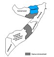
 Territory held by Ahlu Sunna Waljama'a.png 250 × 325; 16 KB
-
 The armed faction of the Somali territory in 1992.png 707 × 900; 175 KB
-
 Us-attack-in-somalia-01082007-2134.svg 493 × 645; 845 KB
-
 Somali Civil War (2009-present).svg 512 × 650; 506 KB
.png)


.png)


.svg)
.png)


.svg)


.png)


