Category:Maps of West Bengal
States of India: Andhra Pradesh · Arunachal Pradesh · Assam · Bihar · Chhattisgarh · Goa · Gujarat · Haryana · Himachal Pradesh · Jharkhand · Karnataka · Kerala · Madhya Pradesh · Maharashtra · Manipur · Meghalaya · Mizoram · Nagaland · Odisha · Punjab · Rajasthan · Sikkim · Tamil Nadu · Telangana · Tripura · Uttar Pradesh · Uttarakhand · West Bengal
Union territories: Andaman and Nicobar Islands · Chandigarh · Dadra and Nagar Haveli and Daman and Diu · Delhi · Jammu and Kashmir · Ladakh · Lakshadweep · Puducherry
Former states of India: Jammu and Kashmir ·
Former union territories: Dadra and Nagar Haveli district · Daman and Diu ·
Union territories: Andaman and Nicobar Islands · Chandigarh · Dadra and Nagar Haveli and Daman and Diu · Delhi · Jammu and Kashmir · Ladakh · Lakshadweep · Puducherry
Former states of India: Jammu and Kashmir ·
Former union territories: Dadra and Nagar Haveli district · Daman and Diu ·
Wikimedia category | |||||
| Upload media | |||||
| Instance of | |||||
|---|---|---|---|---|---|
| Category combines topics | |||||
| West Bengal | |||||
Indian state  someja satełitar in otobre .svg)  | |||||
| Instance of | |||||
| Named after | |||||
| Location | India | ||||
| Capital | |||||
| Legislative body | |||||
| Executive body |
| ||||
| Official language | |||||
| Head of state |
| ||||
| Head of government | |||||
| Inception |
| ||||
| Highest point | |||||
| Population |
| ||||
| Area |
| ||||
| Replaces |
| ||||
| official website | |||||
 | |||||
Subcategories
This category has the following 19 subcategories, out of 19 total.
!
*
B
- Blank maps of West Bengal (5 F)
D
- Maps of the Damodar River (5 F)
L
- Location maps of West Bengal (4 F)
O
S
T
Pages in category "Maps of West Bengal"
This category contains only the following page.
Media in category "Maps of West Bengal"
The following 23 files are in this category, out of 23 total.
-
 Ag.Cli.Re.WB(Ind).jpg 1,540 × 2,150; 200 KB
-
 AGRO-CLIMATE.WBpp.jpg 1,547 × 1,962; 192 KB
-
 India West Bengal relief map.svg 974 × 1,486; 1.83 MB
-
 Kolkata Metropolitan Region.gif 800 × 1,183; 130 KB
-
 Malda freedom.jpg 156 × 169; 40 KB
-
 Map India and Pakistan 1-250,000 Tile NF 45-3 Burdwan.jpg 5,000 × 3,779; 3.87 MB
-
 Map of North Bengal.png 440 × 521; 73 KB
-
 Mayurbhanj Midnapore border 1776.jpg 3,028 × 2,271; 10.25 MB
-
 Nayachar Map.jpg 819 × 1,292; 339 KB
-
 Rarh.jpg 250 × 250; 52 KB
-
 Road-map 01.jpg 249 × 200; 6 KB
-
 South - N North Bengal in India.png 200 × 237; 29 KB
-
 Sunderbans map.png 3,666 × 2,831; 16.54 MB
-
 Tetulia Corridor India Bangladesh.png 949 × 597; 569 KB
-
 West Bengal locator map svg bangla.png 1,595 × 2,256; 668 KB
-
 West Bengal locator map.svg 1,595 × 2,256; 254 KB
-
 West Bengal outline map.svg 1,382 × 2,036; 63 KB
-
 West Bengal outline shape.svg 300 × 300; 309 KB
-
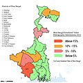 West Bengal Scheduled Tribes Demographic.jpg 1,280 × 1,280; 352 KB
-
 West Bengal Tourism Map.jpg 1,024 × 1,562; 270 KB
-
 Westbengalimap.png 764 × 686; 278 KB
-
 হলদিয়া-ফারাক্কা জলপথ.png 206 × 742; 213 KB
-
 ᱜᱟᱡᱚᱞ.jpg 384 × 683; 89 KB
.jpg)


