Category:Maps of Worcester County, Massachusetts
Counties of Massachusetts: Barnstable · Berkshire · Bristol · Dukes · Essex · Franklin · Hampden · Hampshire · Middlesex · Nantucket · Norfolk · Plymouth · Suffolk · Worcester
Wikimedia category | |||||
| Upload media | |||||
| Instance of | |||||
|---|---|---|---|---|---|
| Category combines topics | |||||
| Worcester County | |||||
county in Massachusetts, United States   | |||||
| Instance of | |||||
| Named after | |||||
| Location | Massachusetts | ||||
| Capital | |||||
| Inception |
| ||||
| Population |
| ||||
| Area |
| ||||
| Different from | |||||
 | |||||
Subcategories
This category has the following 28 subcategories, out of 28 total.
A
B
C
G
L
M
N
S
W
Media in category "Maps of Worcester County, Massachusetts"
The following 30 files are in this category, out of 30 total.
-
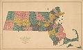 1876 2nd Worcester senate district map Massachusetts.jpg 3,200 × 1,949; 1.1 MB
-

-
-

-
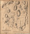
 A map of Mendon, Worcester County, Mass. LOC 80695184.jpg 6,311 × 9,142; 8.4 MB
-
 A map of Mendon, Worcester County, Mass. LOC 80695184.tif 6,311 × 9,142; 165.07 MB
-
 Braggville 1850-1880, Map of.svg 2,217 × 1,478; 688 KB
-
 Crown and Eagle Mills - HABS MA-991 - 077281pu.jpg 5,000 × 3,632; 9.2 MB
-
 Ma01 109.gif 634 × 379; 29 KB
-
 Ma02 109.gif 636 × 379; 28 KB
-
 Ma03 109.gif 635 × 380; 37 KB
-
 Ma05 109.gif 636 × 379; 29 KB
-
 Map of Baldwinville and Winchendon rail road routes (9472266287).jpg 736 × 800; 125 KB
-
 Map of Massachusetts highlighting Worcester County.svg 2,976 × 1,819; 43 KB
-
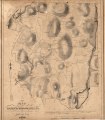
 Map of North-Brookfield LOC 2003620494.jpg 5,254 × 6,027; 5.39 MB
-
 Map of North-Brookfield LOC 2003620494.tif 5,254 × 6,027; 90.6 MB
-
 Map of the Boston-Worcester century run (3855460315).jpg 2,000 × 1,021; 2.44 MB
-
 Map of the town of Blackstone, Worcester County, Mass. (3370514062).jpg 1,586 × 2,000; 3.32 MB
-
 Map of the town of Boylston, Worcester County, Mass. (3370513934).jpg 1,704 × 2,000; 3.7 MB
-
 Map of the town of Millbury (3855700871).jpg 2,000 × 1,339; 2.18 MB
-
 Map of the town of Northbridge (3720895814).jpg 1,024 × 902; 779 KB
-
 Map of the town of Southborough Worcester County, Mass. (7557599244).jpg 2,000 × 1,763; 3.06 MB
-
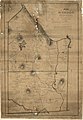
 Map of the town of Upton, Worcester Co., Mass. (3719858991).jpg 712 × 1,024; 590 KB
-
 Map of Worcester County, Massachusetts (2675641996).jpg 2,000 × 1,964; 3.76 MB
-
 Map of Worcester County, Massachusetts. LOC 2005628430.jpg 7,003 × 8,202; 6.73 MB
-
 Map of Worcester County, Massachusetts. LOC 2005628430.tif 7,003 × 8,202; 164.33 MB
-
 Massachusetts location Worcester.svg 500 × 314; 176 KB
-
 Milford, Massachusetts (2673689785).jpg 2,000 × 1,480; 2.92 MB
-
 Milford, Massachusetts, 1888. LOC 2015588504.jpg 10,754 × 7,713; 16.1 MB
-
 Whd topo.jpg 816 × 1,056; 942 KB


.jpg)


.jpg)

.jpg)
.jpg)
.jpg)
.jpg)
.jpg)
.jpg)
.jpg)
.jpg)


.jpg)

