Category:Maps of counties of Washington (state)
States of the United States: Alabama · Alaska · Arizona · Arkansas · California · Colorado · Connecticut · Delaware · Florida · Georgia · Hawaii · Idaho · Illinois · Indiana · Iowa · Kansas · Kentucky · Louisiana · Maine · Maryland · Massachusetts · Michigan · Minnesota · Mississippi · Missouri · Montana · Nebraska · Nevada · New Hampshire · New Jersey · New Mexico · New York · North Carolina · North Dakota · Ohio · Oklahoma · Oregon · Pennsylvania · Rhode Island · South Carolina · South Dakota · Tennessee · Texas · Utah · Vermont · Virginia · Washington · West Virginia · Wisconsin · Wyoming
Counties of Washington (state): Adams · Asotin · Benton · Chelan · Clallam · Clark · Columbia · Cowlitz · Douglas · Ferry · Franklin · Garfield · Grant · Grays Harbor · Island · Jefferson · King · Kitsap · Kittitas · Klickitat · Lewis · Lincoln · Mason · Okanogan · Pacific · Pend Oreille · Pierce · San Juan · Skagit · Skamania · Snohomish · Spokane · Stevens · Thurston · Wahkiakum · Walla Walla · Whatcom · Whitman · Yakima
Subcategories
This category has the following 40 subcategories, out of 40 total.
Media in category "Maps of counties of Washington (state)"
The following 22 files are in this category, out of 22 total.
-
 Blank map subdivisions Washington.svg 122 × 91; 47 KB
-
 County map of Washington state horizontal latitudes.jpg 1,127 × 791; 121 KB
-
 County map of Washington state.svg 1,024 × 768; 54 KB
-
 LINCOLN (WASHINGTON e IDAHO).png 587 × 307; 21 KB
-
 Lincoln in WA and ID.png 450 × 316; 11 KB
-
 Map of Seattle–Tacoma–Bellevue MSA and Seattle–Tacoma–Olympia CSA.svg 1,696 × 1,104; 113 KB
-
 Map of Washington counties, blank.svg 1,781 × 1,159; 215 KB
-
 Moses Lake-Othello Combined Statistical Area.svg 1,781 × 1,159; 227 KB
-
 NRHP Washington Map.svg 990 × 765; 5.98 MB
-
 Puget Sound CSA.png 1,162 × 860; 423 KB
-
 Pullman-Moscow Combined Statistical Area.svg 3,228 × 2,416; 498 KB
-
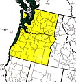 Sitka Spruce Distribution West Coast (22028021152).jpg 1,360 × 1,465; 1.21 MB
-
 Spokane Metropolitan Area.svg 1,793 × 1,171; 228 KB
-
 Spokane-Coeur d'Alene Combined Statistical Area.svg 3,228 × 2,416; 498 KB
-
 Tri-Cities metropolitan area.svg 1,913 × 1,249; 232 KB
-
 Washington administrative map-fr.svg 1,031 × 675; 4.06 MB
-
 Washington Republican Caucuses Results.jpg 721 × 577; 133 KB
-
 Washington State County Map.png 474 × 400; 115 KB
-
 Washington State Map - 1914.jpg 3,350 × 2,443; 3.62 MB
-
 Washington-counties-map.gif 818 × 548; 36 KB
-
 Wenatchee metro map.svg 1,781 × 1,159; 220 KB
-
 Wenatchee Metropolitan Area.svg 1,781 × 1,159; 227 KB


.png)


.jpg)


