Category:Maps of local municipalities of the Eastern Cape
Media in category "Maps of local municipalities of the Eastern Cape"
The following 31 files are in this category, out of 31 total.
-
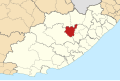
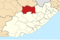
 Map of the Eastern Cape with Amahlathi highlighted (2016).svg 928 × 620; 644 KB
-
 Map of the Eastern Cape with Blue Crane Route highlighted (2016).svg 928 × 620; 632 KB
-
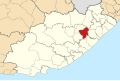
 Map of the Eastern Cape with Dr Beyers Naudé highlighted (2016).svg 928 × 620; 634 KB
-
 Map of the Eastern Cape with Elundini highlighted (2016).svg 928 × 620; 641 KB
-
 Map of the Eastern Cape with Emalahleni highlighted (2016).svg 928 × 620; 633 KB
-
 Map of the Eastern Cape with Engcobo highlighted (2016).svg 928 × 620; 632 KB
-
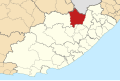
 Map of the Eastern Cape with Enoch Mgijima highlighted (2016).svg 928 × 620; 640 KB
-
 Map of the Eastern Cape with Great Kei highlighted (2016).svg 928 × 620; 637 KB
-
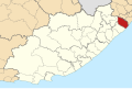
 Map of the Eastern Cape with Ingquza Hill highlighted (2016).svg 928 × 620; 641 KB
-
 Map of the Eastern Cape with Intsika Yethu highlighted (2016).svg 928 × 620; 642 KB
-
 Map of the Eastern Cape with Inxuba Yethemba highlighted (2016).svg 928 × 620; 635 KB
-
-
 Map of the Eastern Cape with Kou-Kamma highlighted (2016).svg 928 × 620; 631 KB
-
 Map of the Eastern Cape with Kouga highlighted (2016).svg 928 × 620; 631 KB
-
 Map of the Eastern Cape with Makana highlighted (2016).svg 928 × 620; 638 KB
-
 Map of the Eastern Cape with Matatiele highlighted (2016).svg 928 × 620; 642 KB
-
 Map of the Eastern Cape with Mbhashe highlighted (2016).svg 928 × 620; 644 KB
-
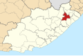
 Map of the Eastern Cape with Mbizana highlighted (2016).svg 928 × 620; 641 KB
-
 Map of the Eastern Cape with Mhlontlo highlighted (2016).svg 928 × 620; 648 KB
-
 Map of the Eastern Cape with Mnquma highlighted (2016).svg 928 × 620; 643 KB
-
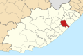
 Map of the Eastern Cape with Ndlambe highlighted (2016).svg 928 × 620; 631 KB
-
 Map of the Eastern Cape with Ngqushwa highlighted (2016).svg 928 × 620; 640 KB
-
 Map of the Eastern Cape with Ntabankulu highlighted (2016).svg 928 × 620; 637 KB
-
 Map of the Eastern Cape with Nyandeni highlighted (2016).svg 928 × 620; 641 KB
-
 Map of the Eastern Cape with Port St Johns highlighted (2016).svg 928 × 620; 634 KB
-
 Map of the Eastern Cape with Raymond Mhlaba highlighted (2016).svg 928 × 620; 641 KB
-
 Map of the Eastern Cape with Sakhisizwe highlighted (2016).svg 928 × 620; 630 KB
-
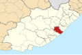
 Map of the Eastern Cape with Senqu highlighted (2016).svg 928 × 620; 640 KB
-
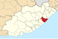
 Map of the Eastern Cape with Sundays River Valley highlighted (2016).svg 928 × 620; 634 KB
-
 Map of the Eastern Cape with Umzimvubu highlighted (2016).svg 928 × 620; 642 KB
-
 Map of the Eastern Cape with Walter Sisulu highlighted (2016).svg 928 × 620; 646 KB
.svg)
.svg)
.svg)
.svg)
.svg)
.svg)
.svg)
.svg)
.svg)
.svg)
.svg)
.svg)
.svg)
.svg)
.svg)
.svg)
.svg)
.svg)
.svg)
.svg)
.svg)
.svg)
.svg)
.svg)
.svg)
.svg)
.svg)
.svg)
.svg)
.svg)
.svg)