Category:Maps of local municipalities of the Free State
Media in category "Maps of local municipalities of the Free State"
The following 18 files are in this category, out of 18 total.
-
 Map of the Free State with Dihlabeng highlighted (2016).svg 828 × 693; 655 KB
-
 Map of the Free State with Kopanong highlighted (2016).svg 828 × 693; 664 KB
-
 Map of the Free State with Letsemeng highlighted (2016).svg 828 × 693; 656 KB
-
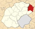
 Map of the Free State with Mafube highlighted (2016).svg 828 × 693; 653 KB
-
 Map of the Free State with Maluti-a-Phofung highlighted (2016).svg 828 × 693; 652 KB
-
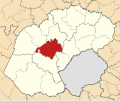
 Map of the Free State with Mantsopa highlighted (2016).svg 828 × 693; 653 KB
-
 Map of the Free State with Masilonyana highlighted (2016).svg 828 × 693; 654 KB
-
 Map of the Free State with Matjhabeng highlighted (2016).svg 828 × 693; 651 KB
-
 Map of the Free State with Metsimaholo highlighted (2016).svg 828 × 693; 652 KB
-
 Map of the Free State with Mohokare highlighted (2016).svg 828 × 693; 664 KB
-
 Map of the Free State with Moqhaka highlighted (2016).svg 828 × 693; 662 KB
-
 Map of the Free State with Nala highlighted (2016).svg 828 × 693; 655 KB
-
 Map of the Free State with Ngwathe highlighted (2016).svg 828 × 693; 653 KB
-
 Map of the Free State with Nketoana highlighted (2016).svg 828 × 693; 653 KB
-
 Map of the Free State with Phumelela highlighted (2016).svg 828 × 693; 666 KB
-
 Map of the Free State with Setsoto highlighted (2016).svg 828 × 693; 657 KB
-
 Map of the Free State with Tokologo highlighted (2016).svg 828 × 693; 655 KB
-
 Map of the Free State with Tswelopele highlighted (2016).svg 828 × 693; 655 KB
.svg)
.svg)
.svg)
.svg)
.svg)
.svg)
.svg)
.svg)
.svg)
.svg)
.svg)
.svg)
.svg)
.svg)
.svg)
.svg)
.svg)
.svg)