Category:Maps of municipalities in Entremont District
Subcategories
This category has the following 2 subcategories, out of 2 total.
Media in category "Maps of municipalities in Entremont District"
The following 12 files are in this category, out of 12 total.
-
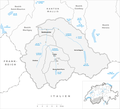
 Carte commune district Entremont 2021.png 1,476 × 1,346; 381 KB
-
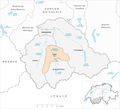
 Karte Gemeinden des Bezirks Entremont 2021.png 1,476 × 1,346; 361 KB
-
 Carte commune Bourg-Saint-Pierre 2021.png 1,476 × 1,346; 382 KB
-
 Karte Gemeinde Bourg-Saint-Pierre 2021.png 1,476 × 1,346; 362 KB
-
 Carte commune Liddes 2021.png 1,476 × 1,346; 381 KB
-
 Karte Gemeinde Liddes 2021.png 1,476 × 1,346; 362 KB
-
 Carte commune Orsières 2021.png 1,476 × 1,346; 382 KB
-
 Karte Gemeinde Orsières 2021.png 1,476 × 1,346; 363 KB
-
 Carte commune Sembrancher 2021.png 1,476 × 1,346; 381 KB
-
 Karte Gemeinde Sembrancher 2021.png 1,476 × 1,346; 362 KB
-
 Carte commune Val de Bagnes 2021.png 1,476 × 1,346; 383 KB
-
 Karte Gemeinde Val de Bagnes 2021.png 1,476 × 1,346; 363 KB


