Category:Maps of provinces of Lombardy
- Regions of Italy: Abruzzo · Apulia · Basilicata · Calabria · Campania · Emilia-Romagna · Friuli-Venezia Giulia · Lazio · Liguria · Lombardy · Marche · Molise · Piedmont · Sardinia · Sicily · Trentino-South Tyrol · Tuscany · Umbria · Veneto
Subcategories
This category has the following 12 subcategories, out of 12 total.
B
C
L
M
P
S
V
Media in category "Maps of provinces of Lombardy"
The following 18 files are in this category, out of 18 total.
-
 Como province map.svg 744 × 1,052; 945 KB
-
 Lombardie70.gif 1,158 × 972; 58 KB
-
 Lombardia province.svg 300 × 300; 170 KB
-
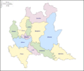
 Lombardy Provinces.png 800 × 600; 145 KB
-
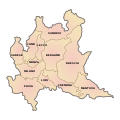
 Lombardy Provinces-el.png 800 × 600; 128 KB
-
 Map of Metropolitan city of Milan (region Lombardy, Italy).svg 5,930 × 5,262; 196 KB
-
 Map of province of Bergamo (region Lombardy, Italy).svg 5,930 × 5,262; 196 KB
-
 Map of province of Brescia (region Lombardy, Italy).svg 5,930 × 5,262; 196 KB
-
 Map of province of Como (region Lombardy, Italy).svg 5,930 × 5,262; 196 KB
-
 Map of province of Cremona (region Lombardy, Italy).svg 5,930 × 5,262; 196 KB
-
 Map of province of Lecco (region Lombardy, Italy).svg 5,930 × 5,262; 196 KB
-
 Map of province of Lodi (region Lombardy, Italy).svg 5,930 × 5,262; 196 KB
-
 Map of province of Mantua (region Lombardy, Italy).svg 5,930 × 5,262; 196 KB
-
 Map of province of Monza and Brianza (region Lombardy, Italy).svg 5,930 × 5,262; 196 KB
-
 Map of province of Pavia (region Lombardy, Italy).svg 5,930 × 5,262; 196 KB
-
 Map of province of Sondrio (region Lombardy, Italy).svg 5,930 × 5,262; 196 KB
-
 Map of province of Varese (region Lombardy, Italy).svg 5,930 × 5,262; 196 KB
-
 Sondrio mappa.png 750 × 449; 149 KB


.svg)
.svg)
.svg)
.svg)
.svg)
.svg)
.svg)
.svg)
.svg)
.svg)
.svg)
.svg)
