Category:Maps of territories in the Swabian Circle
Subcategories
This category has the following 4 subcategories, out of 4 total.
B
W
Media in category "Maps of territories in the Swabian Circle"
The following 19 files are in this category, out of 19 total.
-
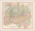 1799 map of Swabia by John Cary.jpg 13,999 × 12,380; 33.21 MB
-
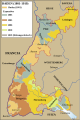
 Baden-1803-1819.png 460 × 690; 101 KB
-
 Baden-es.svg 460 × 690; 289 KB
-
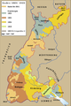 Baden.png 1,906 × 2,869; 695 KB
-
 Baden.svg 460 × 690; 161 KB
-

-
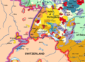 HRR 1789 EN rhine bank cut out.png 921 × 677; 530 KB
-
 Karte Werdenberger.png 1,500 × 2,194; 615 KB
-
 Kreisviertel.jpg 943 × 1,111; 664 KB
-
 Schwäbischer Reichskreis 1805.jpg 1,920 × 1,712; 3.87 MB
-
 Swabian Circle hu.PNG 610 × 599; 212 KB
-
 Swabian Circle-2005-10-15-de.png 727 × 714; 62 KB
-
 Swabian Circle-2005-10-15-en.png 727 × 714; 67 KB
-
 UBBasel Map Basel-Landschaft Schwaben Schwäbischer Reichskreis 1573 Kartenslg Schw Cl 2.tif 6,039 × 7,652, 2 pages; 266.16 MB
-
 UBBasel Map Basel-Landschaft Schwaben Schwäbischer Reichskreis 1573 Kartenslg Schw Cl 2a.tif 7,447 × 7,668, 2 pages; 163.4 MB
-
 UBBasel Map Basel-Landschaft Schwaben Schwäbischer Reichskreis 1573 Kartenslg Schw Cl 2b.tif 6,420 × 6,072, 2 pages; 111.55 MB
-
 UBBasel Map Schwaben Schwäbischer Reichskreis 1575 Kartenslg AA 50.tif 13,582 × 12,659; 491.92 MB
-
 UBBasel Map Schwaben Schwäbischer Reichskreis 1670-1690 Kartenslg Mappe 246-49.tif 11,456 × 9,083, 2 pages; 297.73 MB
-
 Wuerttemberg1.png 2,079 × 2,870; 762 KB


