Category:Maps of the East Riding of Yorkshire
Ceremonial counties of England: Bedfordshire · Berkshire · Buckinghamshire · Cambridgeshire · Cheshire · Cornwall · Cumbria · Derbyshire · Devon · Dorset · Durham · East Riding of Yorkshire · East Sussex · Essex · Gloucestershire · Greater London · Greater Manchester · Hampshire · Herefordshire · Hertfordshire · Isle of Wight · Kent · Lancashire · Leicestershire · Lincolnshire · Merseyside · Norfolk · North Yorkshire · Northamptonshire · Northumberland · Nottinghamshire · Oxfordshire · Rutland · Shropshire · Somerset · South Yorkshire · Staffordshire · Suffolk · Surrey · Tyne and Wear · Warwickshire · West Midlands · West Sussex · West Yorkshire · Wiltshire · Worcestershire
City-counties: Bristol · City of London
Former historic counties: Cumberland · Huntingdonshire · Middlesex · Sussex · Westmorland · Yorkshire
Other former counties: Cleveland · Humberside · Isle of Ely ·
City-counties: Bristol · City of London
Former historic counties: Cumberland · Huntingdonshire · Middlesex · Sussex · Westmorland · Yorkshire
Other former counties: Cleveland · Humberside · Isle of Ely ·
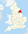
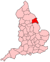
English: The East Riding of Yorkshire is a local government district with unitary authority status, and is a ceremonial county of England. It is named after the historic East Riding of Yorkshire (one of three ridings alongside the North Riding and West Riding), which also constituted a ceremonial and administrative county until 1974. From 1974 to 1996 the area of the modern East Riding of Yorkshire constituted the northern part of Humberside.
As a ceremonial county, it borders North Yorkshire, South Yorkshire and Lincolnshire, and includes the city of Kingston upon Hull, which is a separate unitary authority. As a district it borders North East Lincolnshire (over the Humber estuary), North Lincolnshire (over the Humber and on land), Hull, Doncaster, Selby, York, Ryedale and Scarborough.
By area, the East Riding is both the largest district and the largest unitary authority area in England. By population, it is the second largest non-metropolitan district (unitary or not) in England, after Bristol.Subcategories
This category has the following 8 subcategories, out of 8 total.
!
E
M
W
Media in category "Maps of the East Riding of Yorkshire"
The following 28 files are in this category, out of 28 total.
-
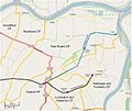 Adlingfleet map.jpg 758 × 635; 69 KB
-
 Admiralty Chart No 1200 Hartlepool to Flamborough Head, Published 1968.jpg 16,378 × 11,276; 35.11 MB
-
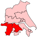
 BeverleyHolderness2007Constituency.svg 210 × 207; 134 KB
-
 BeverleyHoldernessConstituency.svg 200 × 200; 38 KB
-
 BriggGoole2007Constituency.svg 210 × 207; 134 KB
-
 BriggGooleConstituency.svg 200 × 200; 38 KB
-
 Cherry Cobb Sands.jpg 2,074 × 2,692; 1.03 MB
-
 East Riding Ceremonial Numbered.png 200 × 161; 9 KB
-
 East Riding of Yorks outline map with UK.png 722 × 552; 242 KB
-
 East Riding of Yorkshire numbered districts.svg 1,425 × 1,107; 476 KB
-
 East Riding of Yorkshire UK district map (blank).svg 1,425 × 1,107; 767 KB
-
 East Riding of Yorkshire UK location map.svg 1,425 × 1,107; 1.33 MB
-
 East Riding of Yorkshire UK locator map 2010.svg 1,108 × 1,345; 302 KB
-
 East Riding of Yorkshire UK relief location map.jpg 1,999 × 1,551; 225 KB
-
 East Riding of Yorkshire UK ward map (blank).svg 1,425 × 1,107; 1.1 MB
-
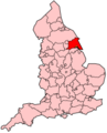 EnglandEastRiding.png 200 × 247; 22 KB
-
 EnglandYorkshireEastRiding1965.png 200 × 254; 24 KB
-
 ERY.svg 1,129 × 1,385; 107 KB
-
 Haltemprice priory os map 1855.png 1,314 × 1,029; 56 KB
-
 Hessle - East Riding of Yorkshire dot.png 1,802 × 2,589; 189 KB
-
 HullWestHessleConstituency.svg 200 × 200; 38 KB
-
 Humberside 1974 Numbered.png 200 × 197; 5 KB
-
 Map of Skipsea Castle.png 420 × 436; 137 KB
-
 Ordnance Survey 1-250000 - SE.jpg 4,000 × 4,000; 8.57 MB
-
 Ordnance Survey 1-250000 - TA.jpg 4,000 × 4,000; 2.3 MB
-
 Revised Boundaries of East Yorkshire.png 240 × 204; 7 KB
-
 Stamford Bridge - East Riding of Yorkshire dot.png 417 × 599; 122 KB
-
 Swinefleet and Reedness map.jpg 684 × 769; 72 KB


.svg)
.svg)