Category:Maps of the Isle of Mull
Media in category "Maps of the Isle of Mull"
The following 36 files are in this category, out of 36 total.
-
 Blaeu - Atlas of Scotland 1654 - MVLA INSVLA - The Isle of Mull.jpg 6,392 × 5,067; 6.38 MB
-

-
 Admiralty Chart No 1836 Plans on the west coast of Scotland, Published 1959.jpg 11,038 × 8,225; 21.74 MB
-
 Admiralty Chart No 2155 Sound and North West Coast of Mull, Published 1852.jpg 12,237 × 9,047; 14.58 MB
-
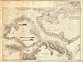
 Admiralty Chart No 2515 Scotland west coast Mull of Cantyre to Ardnamurchan, Published 1868.jpg 10,249 × 12,652; 15.3 MB
-
 Admiralty Chart No 2771 Loch Scridain, Surveyed 1859.jpg 11,333 × 7,579; 30.95 MB
-
 Admiralty Chart No 2813 Lochs Buie and Spelve, Published 1954.jpg 12,311 × 8,457; 34.64 MB
-
 Admiralty Chart No 2813 Lochs Buy and Spelve, Published 1862.jpg 9,997 × 6,712; 26.78 MB
-
 Admiralty Chart No 2832 Treshnish Point to the entrance of the Sound of Mull, Published 1864.jpg 16,317 × 12,057; 48.72 MB
-
 Admiralty Chart No 3015 Loch na Keal, Published 1909.jpg 15,794 × 10,898; 87.12 MB
-
-
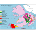 Geology of Mull.png 3,452 × 3,004; 934 KB
-

-
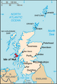 Isle of Mull.png 253 × 372; 34 KB
-
 Judd Geological Map Inner Hebrides 1878.jpg 2,822 × 4,745; 837 KB
-

-
 Mid 18th century map of Mull.JPG 3,088 × 2,056; 3.6 MB
-
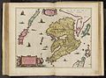 Mula Insula by Blaeu 1665.jpg 9,054 × 6,705; 9.33 MB
-
 Mull Inner Hebrides.svg 1,161 × 2,563; 4.35 MB
-
 Mull.PNG 199 × 218; 4 KB
-
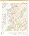
 Mull.topographic.nolabel.jpg 600 × 465; 64 KB
-
 Oban South and the Isles.svg 1,254 × 1,281; 362 KB
-
 Ordnance Survey One-Inch Sheet 45 Sound of Mull, Published 1956.jpg 8,241 × 9,882; 9.42 MB
-
 Ordnance Survey One-Inch Sheet 51 Iona & Colonsay, Published 1956.jpg 8,588 × 10,676; 14.25 MB
-
 Ordnance Survey One-inch Sheet 52 Loch Awe, Published 1956.jpg 8,604 × 10,703; 19.42 MB
-
 Ordnance Survey One-Inch Sheet 53 Sound of Mull, Published 1947.jpg 14,014 × 9,301; 13.15 MB
-
 Ordnance Survey One-Inch Sheet 59 Iona & Colonsay, Published 1927.jpg 9,872 × 14,660; 9.93 MB
-
 Ordnance Survey One-Inch Sheet 60 North Jura and Firth of Lorne, Published 1925.jpg 8,823 × 14,239; 11.94 MB
-
 Ordnance Survey Quarter-inch sheet 4 Western Highlands, published 1967.jpg 9,627 × 8,869; 8.85 MB
-
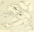
 PSM V20 D372 Plan of the dissected vulcano of mull inner hebrides.jpg 1,437 × 1,601; 378 KB
-
 Richey tertiary igneous complex Mull.jpg 2,955 × 2,830; 771 KB
-
 Richey tertiary plateau lavas Mull.jpg 2,668 × 2,846; 758 KB
-
 The Quarterly journal of the Geological Society of London (12734300744).jpg 1,855 × 1,421; 672 KB
-
 The Quarterly journal of the Geological Society of London (1874) (14744760266).jpg 3,466 × 2,564; 1.22 MB
-
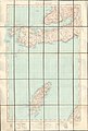
 The sound of Mull. Mackenzie 74400890.jpg 9,870 × 6,798; 12.08 MB
-
 The west side of the island Mull with the islands Tiri and Coll Mackenzie 74400891.jpg 9,639 × 6,961; 12.08 MB

.jpg)


.png)

.jpg)


.jpg)
_(14744760266).jpg)

