Category:Maps of the Metropolitan Borough of Kirklees
Media in category "Maps of the Metropolitan Borough of Kirklees"
The following 28 files are in this category, out of 28 total.
-
 Dewsbury unparished area UK locator map.svg 1,358 × 1,345; 407 KB
-
 EnglandKirklees.png 200 × 247; 17 KB
-
 Huddersfield - Kirklees dot.png 1,802 × 2,589; 189 KB
-
 Huddersfield to Bradford & Wakefield proximity.jpg 860 × 745; 549 KB
-
 Huddersfield unparished area UK locator map.svg 1,358 × 1,345; 407 KB
-
 Kirklees (43042941061).png 1,850 × 1,316; 128 KB
-
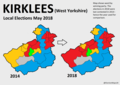
 KIRKLEES (49911037162).png 2,160 × 1,080; 171 KB
-
 Kirklees District Areas.svg 957 × 883; 342 KB
-
 Kirklees in England (special marker).svg 816 × 991; 1.32 MB
-
 Kirklees in England (zoom).svg 816 × 991; 821 KB
-
 Kirklees in England.svg 816 × 991; 1.32 MB
-
 Kirklees UK local election 2021 map.svg 1,358 × 1,345; 569 KB
-
 Kirklees UK locator map.svg 1,425 × 1,039; 765 KB
-
 Kirklees UK ward map 2006.svg 1,358 × 1,345; 568 KB
-
 Kirklees UK ward map 2007.svg 1,358 × 1,345; 568 KB
-
 Kirklees UK ward map 2008.svg 1,358 × 1,345; 568 KB
-
 Kirklees UK ward map 2010 (blank).svg 1,358 × 1,345; 567 KB
-
 Kirklees UK ward map 2010.svg 1,358 × 1,345; 568 KB
-
 Kirklees UK ward map 2011.svg 1,358 × 1,345; 568 KB
-
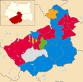
 Kirklees UK ward map 2018 Election.svg 1,358 × 1,345; 568 KB
-
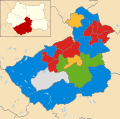
 Kirklees UK ward map 2019 Election.svg 1,358 × 1,345; 569 KB
-
 Kirklees wards 2016.png 1,358 × 1,345; 314 KB
-
 Newsome (1982-2004, ward).svg 797 × 760; 85 KB
-
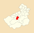
 Newsome (ward).svg 1,358 × 1,345; 351 KB
-
 WestYorkshire-Kirklees.png 494 × 392; 51 KB
-
 WestYorkshire-UrbanArea-Map.jpg 1,781 × 1,711; 616 KB
-
 WYorks-Kirklees.png 200 × 157; 7 KB
-
 Yorkshire Forced Rhubarb triangle.png 1,889 × 1,619; 5.96 MB


.png)
.png)

.svg)
.svg)


.svg)
.svg)


.svg)