Category:Maps of the Upper Peninsula
Media in category "Maps of the Upper Peninsula"
The following 20 files are in this category, out of 20 total.
-
 1842TreatyOfLaPointe.jpg 1,650 × 1,200; 1.2 MB
-
 1849 Land Survey Map of Michigan Upper Peninsula - Geographicus - Michigan-ls-1850.jpg 3,000 × 1,810; 964 KB
-
 2015 Upper Peninsula Population Density Map.jpg 1,280 × 720; 69 KB
-
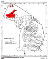
 Central Upper Peninsula within Michigan's Upper Peninsula.jpg 1,280 × 720; 48 KB
-
 Eastern Upper Peninsula within Michigan's Upper Peninsula.jpg 1,280 × 720; 53 KB
-
 Escanaba-and-lake-superior-map.jpg 1,607 × 2,400; 989 KB
-
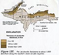 Jacobsville Sandstone Thickness.jpeg 373 × 346; 116 KB
-
 Map of Michigan highlighting Copper Country.gif 1,176 × 1,444; 90 KB
-
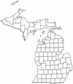 MIMap-doton-Menominee.PNG 261 × 300; 13 KB
-
 Michigan 12 1926 map.png 2,205 × 1,286; 95 KB
-
 Michigan 28 map.png 2,172 × 1,333; 83 KB
-
 MichiganCSTCounties.svg 534 × 605; 142 KB
-
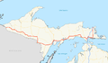
 MichiganUpperPeninsula.svg 441 × 411; 102 KB
-
 UPmap.JPG 552 × 381; 31 KB
-
 Upper Peninsula 2015 Population Density Map.jpg 1,280 × 720; 83 KB
-
 Upper Peninsula counties map.svg 615 × 584; 1.84 MB
-
 Upper Peninsula of Michigan.png 553 × 382; 20 KB
-
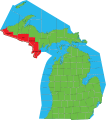
 Upper peninsula Toledo War.png 553 × 382; 21 KB
-
 UpperPeninsula.png 553 × 382; 8 KB
-
 Western Upper Peninsula within Michigan's Upper Peninsula.jpg 1,280 × 720; 49 KB


