Category:Maps of the War of 1812
Media in category "Maps of the War of 1812"
The following 57 files are in this category, out of 57 total.
-

-

-

-
-
-

-

-
 Anglo American War 1812 Locations map-ar.svg 1,052 × 744; 1.02 MB
-
 Anglo American War 1812 Locations map-en he.svg 1,503 × 836; 439 KB
-
 Anglo American War 1812 Locations map-en.svg 1,052 × 744; 136 KB
-
 Anglo American War 1812 Locations map-es.svg 1,494 × 830; 127 KB
-
 Anglo American War 1812 Locations map-fr.svg 1,494 × 830; 206 KB
-

-
 Battle of Chippawa.gif 760 × 759; 67 KB
-
 Battle of Fort Stephenson from 1912 History Book.png 927 × 623; 149 KB
-
 Battle of Lake Borgne.jpg 5,312 × 2,988; 4.44 MB
-
 Battle of St Michaels troop positions 11 barges.png 913 × 703; 175 KB
-
 BattleOfNewOrleansAreaMap.jpg 1,100 × 1,091; 294 KB
-
 British Advance on Washington, August 1814.png 639 × 584; 112 KB
-
 Burnt Corn Battlefield.jpg 793 × 813; 97 KB
-
 Chateaugay.jpg 5,312 × 2,988; 4.55 MB
-

-
 Detroit region 1812.svg 737 × 676; 98 KB
-
 Fort Detroit.jpg 5,312 × 2,988; 4.51 MB
-

-
 Fort St. Philip II.jpg 5,312 × 2,988; 4.79 MB
-
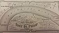 Fort St. Philip.jpg 5,312 × 2,988; 4.7 MB
-

-
 Indian history for young folks (1919) (14753057542).jpg 1,862 × 1,300; 274 KB
-
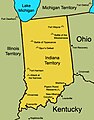 Indiana Territory 1812.jpg 495 × 632; 182 KB
-
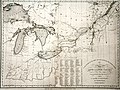 KENSETT MAP CANADA 1812, enhanced.jpg 3,828 × 2,856; 2.5 MB
-
 KENSETT MAP CANADA 1812.jpg 3,828 × 2,856; 2.3 MB
-
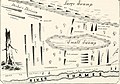
 Lake Borgne 1814.png 363 × 700; 144 KB
-
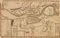
 Map 1814-15 New Orleans. LOC 2007627049.jpg 11,838 × 8,049; 7.99 MB
-
 Map of US in War of 1812 Chesapeake circled.png 527 × 683; 300 KB
-
 McConnell's Historical maps of the United States LOC 2009581130-23.jpg 13,173 × 9,535; 16.3 MB
-
 MeigsBattle.jpg 1,940 × 1,516; 1.3 MB
-
 Niagara River 1812.jpg 1,527 × 858; 155 KB
-
 Niagra River and Territory, 1812.jpg 1,473 × 2,305; 550 KB
-
 Plan of Fort Meigs' and its environs by Sebree, 1813.jpg 11,441 × 7,260; 26.93 MB
-
 Prairie du Chien.png 300 × 388; 68 KB
-
 Presque Isle Bay.jpg 5,312 × 2,988; 4.94 MB
-
 Principal Campaigns of the War of 1812.gif 733 × 1,177; 127 KB
-
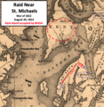 Raid Near St Michaels MD.png 738 × 756; 1.26 MB
-
 Raid Near St Michaels.png 610 × 633; 935 KB
-
 Raid Near St. Michaels Choptank.png 749 × 840; 1.29 MB
-
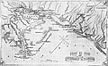 SeatOfWarInLouisianaAndFlorida.jpg 1,100 × 674; 129 KB
-
 Siege of Fort Wayne.jpg 5,312 × 2,988; 4.29 MB
-
 Sketch of the March of the British Army under General Ross.jpg 4,801 × 6,093; 6.35 MB
-
 The War of 1812 in the Chesapeake.jpg 564 × 684; 84 KB
-
 Upper Mississippi 1812 blank.png 816 × 1,056; 19 KB
-
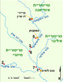 Upper Mississippi 1812 He.png 816 × 1,056; 34 KB
-
 Upper Mississippi 1812.png 816 × 1,056; 68 KB
-
 Views of Old-Time Buffalo p30 a.jpg 2,184 × 3,682; 888 KB
-
 Views of Old-Time Buffalo p30 b.jpg 2,200 × 3,682; 1.27 MB
-
 War 1812-Locations.jpg 1,494 × 830; 139 KB
-
 War of 1812 Detroit Region.png 5,422 × 5,422; 2.04 MB
.jpg)
.jpg)
.jpg)
.jpg)
_(14576269997).jpg)


.jpg)


.jpg)


_(14753057542).jpg)


.jpg)
.jpg)