Category:Maps of the county of Ravensberg
Subcategories
This category has only the following subcategory.
Media in category "Maps of the county of Ravensberg"
The following 17 files are in this category, out of 17 total.
-
 Grafschaft Ravensberg - Amt Limberg in 1801.svg 580 × 450; 109 KB
-
 Grafschaft Ravensberg - Amt Ravensberg in 1801.svg 580 × 450; 109 KB
-
 Grafschaft Ravensberg - Amt Sparrenberg in 1801.svg 580 × 450; 109 KB
-
 Grafschaft Ravensberg - Amt Vlotho in 1801.svg 580 × 450; 109 KB
-
 Grafschaft Ravensberg - Bielefeld in 1801.svg 580 × 450; 109 KB
-
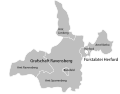
 Grafschaft Ravensberg - Fürstabtei Herford in 1801.svg 580 × 450; 109 KB
-
 Grafschaft Ravensberg - Herford in 1801.svg 580 × 450; 109 KB
-
 Grafschaft Ravensberg - Lage 1806.png 1,642 × 1,470; 183 KB
-
 Grafschaft Ravensberg in 1801.svg 580 × 450; 109 KB
-
 Grafschaft Ravensberg und Fürstentum Minden in 1801.svg 578 × 554; 189 KB
-
 HRR 1789 Fürstbistum Paderborn.png 299 × 278; 84 KB
-
 Karte-minden-ravensberg-1797.jpg 1,800 × 2,538; 2.44 MB
-
 Locator County of Ravensberg (1560).svg 3,821 × 3,455; 374 KB
-
 Minden-Ravensberg - Lage 1806.png 1,642 × 1,470; 187 KB
-
 Minden-Ravensberg-Juli 1806 pol.png 534 × 436; 80 KB
-
 Minden-Ravensberg.png 522 × 464; 442 KB
-
 Zones de cantonnement.png 1,808 × 2,083; 559 KB


.svg)


