Category:Maps of the districts of Ghana
Media in category "Maps of the districts of Ghana"
The following 26 files are in this category, out of 26 total.
-
 Abura Asebu Kwamankese District.png 719 × 351; 33 KB
-
 Ashanti Adansi North.svg 385 × 333; 294 KB
-
 Ashanti districts.png 1,056 × 816; 56 KB
-
 Ashanti Sekyere South.svg 436 × 362; 293 KB
-
 Ashanti Sekyere-Afram Plains.svg 406 × 351; 324 KB
-
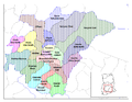
 Districts of the Bono East Region (2019).png 1,438 × 999; 363 KB
-
 Brong Ahafo districts.png 1,056 × 816; 49 KB
-
 Central Ghana districts.png 1,056 × 816; 44 KB
-
 Districts of the Ahafo Region (2019).png 676 × 639; 87 KB
-
 Districts of the Ashanti Region (2012).svg 744 × 524; 3.97 MB
-
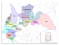
 Districts of the Bono Region (2019).png 779 × 1,168; 170 KB
-
 Districts of the Brong Ahafo Region (2012).svg 744 × 524; 4.08 MB
-
 Districts of the Central Region (2012).svg 744 × 524; 2.03 MB
-
 Districts of the Eastern Region (2012).svg 744 × 524; 2.66 MB
-
 Districts of the Northern Region (2012).svg 744 × 524; 4.9 MB
-
 Districts of the Northern Region (2018).png 3,147 × 3,200; 423 KB
-
 Districts of the Oti Region (2018).png 2,147 × 3,005; 215 KB
-
 Districts of the Savannah Region (2018).png 2,906 × 2,276; 155 KB
-
 Districts of the Upper East Region (2012).svg 744 × 524; 1.37 MB
-
 Districts of the Upper West Region (2012).svg 744 × 524; 1.24 MB
-
 Districts of the Volta Region (2012).svg 524 × 744; 2.98 MB
-
 Districts of the Volta Region (2018).png 2,172 × 2,607; 608 KB
-
 Eastern Ghana districts.png 1,056 × 816; 45 KB
-
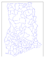 Ghana districts blank.png 816 × 1,056; 30 KB
-
 Ghana districts.png 684 × 995; 27 KB
-
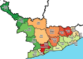
 Districts of the Western Region (2019).png 1,865 × 1,581; 373 KB


.png)


.png)
.svg)
.png)
.svg)
.svg)
.svg)
.svg)
.png)
.png)
.png)
.svg)
.svg)
.svg)
.png)


.png)