Category:Maps of the history of Novi Sad
Media in category "Maps of the history of Novi Sad"
The following 22 files are in this category, out of 22 total.
-
 Novi sad bivse opstine01.png 1,112 × 890; 52 KB
-
 Novi sad bivse opstine02.png 1,001 × 1,240; 86 KB
-
 Novi sad map 1745.jpg 3,112 × 2,054; 2.33 MB
-
 Novi sad map 1805.jpg 1,608 × 2,682; 2.13 MB
-
 Novi sad map 1845.jpg 2,106 × 2,670; 3.08 MB
-
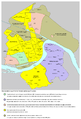 Novi sad quarters ethnic.png 1,800 × 2,646; 970 KB
-
 Novi sad razvoj naselja.png 1,800 × 2,512; 475 KB
-
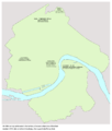
 Novi sad stara naselja01a.png 1,800 × 2,112; 443 KB
-
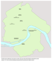
 Novi sad stara naselja01b.png 1,800 × 2,112; 441 KB
-
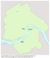
 Novi sad stara naselja01c.png 1,800 × 2,112; 423 KB
-
 Novi sad stara naselja02.png 1,800 × 2,112; 423 KB
-
 Novi sad stara naselja03.png 1,800 × 2,116; 405 KB
-
 Novi sad stara naselja04.png 1,800 × 2,112; 353 KB
-
 NoviSadtrammap.png 1,146 × 767; 716 KB
-
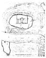 Petrovaradin 1688.jpg 239 × 302; 14 KB
-
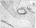 Petrovaradin 1692.jpg 382 × 295; 19 KB
-
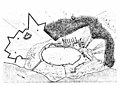 Petrovaradin 1693.jpg 300 × 212; 13 KB
-
 Péterváradi csata-1716.jpg 800 × 617; 250 KB
-
 Ratzen stadt 18thcentury.jpg 1,521 × 1,146; 896 KB
-
 Ratzen Stadt01.jpg 582 × 804; 780 KB
-
 Ratzenstatt and almas 1716 17.jpg 1,486 × 938; 680 KB
-
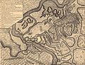
 Siege of Petrovaradin 1694.jpg 300 × 226; 20 KB


