Category:Maps related to Hispanic people in the United States
Media in category "Maps related to Hispanic people in the United States"
The following 11 files are in this category, out of 11 total.
-
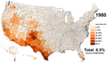 Hispanic Americans 1980 County.png 9,470 × 5,635; 6.79 MB
-
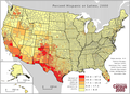
 2020 Census - Majority-Hispanic Counties in the United States.png 7,000 × 4,000; 3.62 MB
-
 Airqualityasian 2022 04.gif 720 × 545; 921 KB
-
 Airqualityasian 2022 05.jpg 720 × 545; 139 KB
-
 Airqualityasian 2022 06.jpg 720 × 545; 214 KB
-
 Census Bureau 2000, Hispanics in the United States.png 696 × 506; 205 KB
-
 Hispanic Americans 1990 County.png 9,470 × 5,635; 11.76 MB
-
 Hispanic Americans 2000 County.png 9,470 × 5,635; 6.8 MB
-
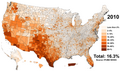 Hispanic Americans 2010 County.png 9,470 × 5,635; 11.49 MB
-
 Hispanic Americans 2020 County.png 9,470 × 5,635; 13.36 MB
-
 Hispanic and Latino Americans by county.png 7,500 × 4,000; 4.47 MB


