Category:Maps with Mercator projection
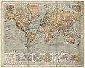
English: The Mercator projection is a cylindrical map projection presented by the Flemish geographer and cartographer Gerardus Mercator in 1569. It became the standard map projection for nautical purposes because of its ability to represent lines of constant course, known as rhumb lines or loxodromes, as straight segments. While the linear scale is equal in all directions around any point, thus preserving the angles and the shapes of small objects (which makes the projection conformal), the Mercator projection distorts the size and shape of large objects, as the scale increases from the equator to the poles, where it becomes infinite.
See also Category:Maps with equirectangular projection (equidistant latitudes)
English: This map-projection-related category exists in the following hierarchy:
- Category:Map projections
- Category:Maps by projection
- Category:Mercator projection – media related to the Mercator projection other than maps
- Category:Maps with Mercator projection (“Category:Mercator projections”) – maps made using the Mercator projection
type of map projection | |||||
| Upload media | |||||
| Instance of | |||||
|---|---|---|---|---|---|
| |||||
Subcategories
This category has the following 8 subcategories, out of 8 total.
Media in category "Maps with Mercator projection"
The following 35 files are in this category, out of 35 total.
-
 2012 Area & Projection Comparisons Calendar (30885483375).jpg 3,300 × 2,550; 1.6 MB
-

-
-
 Armenia NATO Locator.svg 616 × 247; 507 KB
-
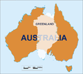 Australia-Greenland Overlay.png 520 × 463; 23 KB
-
 Azerbaijan NATO Locator.svg 616 × 247; 509 KB
-
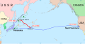 Barge T-36 drift and rescue - en.svg 1,770 × 925; 218 KB
-
 Barge T-36 drift and rescue - ru.svg 1,770 × 925; 232 KB
-
 Barge T-36 drift and rescue 2 - ru.svg 1,207 × 1,235; 444 KB
-
 Belarus NATO Locator.svg 616 × 247; 508 KB
-
 Blank Scotland Map.png 1,075 × 1,742; 57 KB
-
 BoiseExtremeMercator.png 1,920 × 940; 1.38 MB
-
 BR-Albers-Mercator.svg 512 × 512; 57 KB
-
 Buss Distribution Global.png 1,383 × 1,383; 315 KB
-
 Columbia River Mouth and Bar.jpg 3,957 × 2,557; 4.04 MB
-
 Comparative Maps of Asia, H. G. Wells' Outline of History, page 519.jpg 2,160 × 1,240; 457 KB
-
 Countries United States exported to.png 743 × 510; 129 KB
-
 Dottedmapamundi2.png 529 × 336; 60 KB
-
 EdwardWright-MapforSailingtoAzores-1599.jpg 477 × 518; 96 KB
-
 Erhard Etzlaub 1511 Sundial miniature map.png 1,827 × 2,423; 1.53 MB
-
 Expansion territoriale de la Russie.svg 2,074 × 1,612; 948 KB
-
 Expansión territorial de Rusia.svg 1,944 × 1,511; 948 KB
-
 Finland NATO Locator.svg 616 × 247; 508 KB
-
 Flammarion - La planète Mars, Tome 1-f180.jpg 760 × 400; 76 KB
-
 France - 2011 population density - 200 m × 200 m square grid - Dark (bis).png 4,864 × 4,648; 2.35 MB
-
 France - 2011 population density - 200 m × 200 m square grid - Dark.png 5,371 × 5,158; 4.82 MB
-
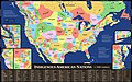 Indigenous American Nations, 16th century - 2022 edition.jpg 17,280 × 10,800; 24.71 MB
-
 JodocusHondius-ChristianKnightMap-1597.jpg 464 × 355; 88 KB
-
 Latvijas teritorija Merkatora projekcijā.svg 1,054 × 622; 29 KB
-
 Mars carte lowell.jpg 3,064 × 2,238; 1.77 MB
-
 Mercator and Etzlaub.png 378 × 381; 157 KB
-
 NATO and BAH.svg 616 × 247; 261 KB
-
 ObliqueMercatorExtremeArcDeTriomphe.png 1,919 × 900; 2.94 MB
-
 Territorial Expansion of Russia.svg 1,944 × 1,511; 1.09 MB
-
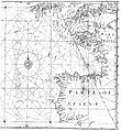
 Tibet and India map detail, from- LA2-Blitz-0103 (cropped).jpg 353 × 274; 46 KB
.jpg)
_-_von_Hermann_Berghaus_-_btv1b53093810g_(1_of_3).jpg)
.jpg)


.png)


.jpg)