Category:Mariakerk, Ruinen
| Object location | | View all coordinates using: OpenStreetMap |
|---|
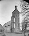
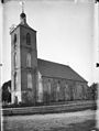
Nederlands: Afbeeldingen van de Mariakerk, Kloosterstraat 4, 7973AH, 7963 AH Ruinen. Gelegen nabij de Brink in Ruinen behorende tot de gemeente De Wolden in de provincie Drenthe in het noorden van Nederland
church building in De Wolden, Netherlands  | |||||
| Upload media | |||||
| Instance of | |||||
|---|---|---|---|---|---|
| Location | Ruinen, Westerveld, Drenthe, Netherlands | ||||
| Street address |
| ||||
| Heritage designation |
| ||||
| Inception |
| ||||
| official website | |||||
 | |||||
Nederlands: Mariakerk, Ruinen - anno 15e eeuw
Kerk:
|
This is a category about rijksmonument number 32969
|
Toren:
|
This is a category about rijksmonument number 32970
|
| Address |
|
Subcategories
This category has only the following subcategory.
I
- Interior of Mariakerk, Ruinen (13 F)
Media in category "Mariakerk, Ruinen"
The following 20 files are in this category, out of 20 total.
-
 20210512 Mariakerk Ruinen.jpg 3,456 × 5,184; 5.32 MB
-
 20210512 zicht op Ruinen2 vanuit het noorden.jpg 4,925 × 3,281; 3.28 MB
-
 20210512 zicht op Ruinen3 vanuit het noorden.jpg 4,888 × 3,256; 2.42 MB
-
 Detail - Ruinen - 20193594 - RCE.jpg 804 × 1,200; 195 KB
-
 Exterieur - Ruinen - 20193592 - RCE.jpg 792 × 1,200; 213 KB
-
 Exterieur - Ruinen - 20193593 - RCE.jpg 1,200 × 806; 313 KB
-
 Exterieur noordgevel - Ruinen - 20193590 - RCE.jpg 788 × 1,200; 251 KB
-
 Exterieur overzicht toren en kerk, noordwestzijde - Ruinen - 20322411 - RCE.jpg 956 × 1,200; 269 KB
-
 Exterieur ZUIDGEVEL, VERSCHILLENDE SOORTEN STEEN, DETAIL - Ruinen - 20275689 - RCE.jpg 1,200 × 1,200; 536 KB
-

-
 Kerk op brink van Ruinen.jpg 730 × 1,172; 213 KB
-
 Kerk vanuit het zuid-oosten - Ruinen - 20193585 - RCE.jpg 1,200 × 894; 300 KB
-
 Kerk vanuit het zuid-westen - Ruinen - 20193586 - RCE.jpg 906 × 1,200; 220 KB
-
 Mariakerk van Ruinen.jpg 1,296 × 972; 332 KB
-
 Marijetsjerke fan Ruinen.jpg 2,000 × 1,334; 1.73 MB
-
 Model fan de Marijetsjerke fan Ruinen foar de 19e-iuwske restauraasje.jpg 2,000 × 1,335; 1.75 MB
-
 Nederlands Hervormde pastorie, middeleeuwse kelder - Ruinen - 20193599 - RCE.jpg 959 × 1,200; 198 KB
-
 P1020018Brink Ruinen.JPG 3,264 × 2,448; 3.78 MB
-
 Pastorie Nederlands Hervormde Gemeente - Ruinen - 20193600 - RCE.jpg 1,200 × 1,199; 391 KB
-
 Ramen exterieur - Ruinen - 20193591 - RCE.jpg 1,200 × 796; 309 KB


