Category:Mariansleigh
village and civil parish in Devon, United Kingdom  | |||||
| Upload media | |||||
| Instance of | |||||
|---|---|---|---|---|---|
| Location | North Devon, Devon, South West England, England | ||||
 | |||||
Media in category "Mariansleigh"
The following 190 files are in this category, out of 190 total.
-
 'The Barton', Mariansleigh - geograph.org.uk - 6231199.jpg 1,024 × 768; 182 KB
-

-

-
 Alswear , Country Lane - geograph.org.uk - 4090637.jpg 4,288 × 2,848; 6.39 MB
-
 Alswear , River Mole - geograph.org.uk - 4090628.jpg 4,288 × 2,848; 6.19 MB
-
 Alswear , The B3137 - geograph.org.uk - 4636264.jpg 4,288 × 2,848; 5.33 MB
-
 Alswear , The B3137 - geograph.org.uk - 4636266.jpg 4,288 × 2,848; 5.99 MB
-
 Alswear , Village Scenery - geograph.org.uk - 4090640.jpg 4,132 × 2,745; 7.14 MB
-
 B3137 approaching Alswear - geograph.org.uk - 3689227.jpg 1,920 × 1,208; 433 KB
-
 B3137 at Woodlands - geograph.org.uk - 3689225.jpg 3,906 × 2,289; 1.05 MB
-
 B3137 closed north of Alswear - geograph.org.uk - 4602908.jpg 1,600 × 1,200; 1.58 MB
-
 B3137 in Little Silver Stream valley - geograph.org.uk - 3689167.jpg 640 × 370; 78 KB
-
 B3137 near Northern Copse - geograph.org.uk - 3704952.jpg 1,920 × 2,174; 548 KB
-
 Bales near Mariansleigh - geograph.org.uk - 5247650.jpg 3,072 × 2,048; 1.44 MB
-
 Barn and signpost, Townliving, Mariansleigh - geograph.org.uk - 5813341.jpg 1,600 × 1,200; 801 KB
-
 Barn at Milltown - geograph.org.uk - 6230999.jpg 1,024 × 768; 180 KB
-
 Barn at Tidlake - geograph.org.uk - 5812961.jpg 1,600 × 1,200; 739 KB
-
 Barn near Mariansleigh - geograph.org.uk - 642746.jpg 426 × 640; 79 KB
-
 Bridge over Little Silver Stream, Alswear - geograph.org.uk - 4602916.jpg 1,200 × 1,600; 1.86 MB
-
 By Trittencott Cross - geograph.org.uk - 5082841.jpg 3,072 × 2,048; 1.54 MB
-
 Cattle at rest on Milltown Hill - geograph.org.uk - 6231014.jpg 1,024 × 761; 203 KB
-
 Cattle near Mariansleigh - geograph.org.uk - 5082829.jpg 1,920 × 1,303; 756 KB
-
 Cattle near Mariansleigh - geograph.org.uk - 5247697.jpg 2,690 × 1,658; 1.15 MB
-
 Cattle pasture near Westacott Farm - geograph.org.uk - 5082709.jpg 2,609 × 1,545; 1.06 MB
-
 Church of St Mary, Mariansleigh - geograph.org.uk - 5247800.jpg 3,072 × 2,048; 1.12 MB
-
 Church of St Mary, Mariansleigh - geograph.org.uk - 5248007.jpg 2,565 × 1,729; 834 KB
-
 Church Room, Mariansleigh - geograph.org.uk - 5078875.jpg 3,072 × 2,048; 1.13 MB
-
 Church Room, Mariansleigh - geograph.org.uk - 5247708.jpg 3,072 × 2,048; 1.07 MB
-
 Church Room, Mariansleigh - geograph.org.uk - 5247734.jpg 2,048 × 3,072; 1.29 MB
-
 Cottages in Alswear (geograph 5279100).jpg 1,252 × 1,666; 479 KB
-
 Countryside near Mariansleigh - geograph.org.uk - 5082730.jpg 1,920 × 1,026; 717 KB
-
 Driveway to Eastacott - geograph.org.uk - 6232698.jpg 1,024 × 766; 263 KB
-
 Eastacott Woods - geograph.org.uk - 5816508.jpg 1,600 × 1,200; 771 KB
-
 Eastacott Woods and patches of marshland - geograph.org.uk - 5816511.jpg 1,600 × 1,200; 676 KB
-
 Farm access at Trittencott - geograph.org.uk - 5816522.jpg 1,600 × 1,200; 914 KB
-
 Farm access road to Hilltown (geograph 5816500).jpg 1,200 × 1,600; 778 KB
-
 Farm buildings at Lower Uppacott - geograph.org.uk - 6231036.jpg 1,024 × 788; 151 KB
-
 Farm buildings, Mariansleigh - geograph.org.uk - 5247744.jpg 3,052 × 1,747; 1.12 MB
-
 Farm track above Tidlake - geograph.org.uk - 6299562.jpg 1,024 × 766; 186 KB
-
 Farm track across fields east of Alswear - geograph.org.uk - 5812952.jpg 1,600 × 1,200; 788 KB
-
 Farm track and footpath to Tidlake and Kempstown - geograph.org.uk - 5812965.jpg 1,200 × 1,600; 849 KB
-
 Farm track north of Tidlake - geograph.org.uk - 5812972.jpg 1,200 × 1,600; 788 KB
-
 Farm track west of Southcott - geograph.org.uk - 5816601.jpg 1,600 × 1,200; 807 KB
-
 Farmland above Alswear - geograph.org.uk - 6299581.jpg 1,024 × 773; 232 KB
-
 Farmland near Mariansleigh - geograph.org.uk - 5082668.jpg 3,072 × 2,048; 1.69 MB
-
 Farmland near Mariansleigh - geograph.org.uk - 5082817.jpg 3,072 × 1,797; 1.44 MB
-
 Farmland southeast of Mariansleigh - geograph.org.uk - 5816484.jpg 1,600 × 1,200; 856 KB
-
 Farmyard, Mariansleigh - geograph.org.uk - 5247794.jpg 3,055 × 1,933; 1.16 MB
-
 Field access east of Alswear - geograph.org.uk - 5812956.jpg 1,600 × 1,200; 825 KB
-
 Field at Tidlake - geograph.org.uk - 5812967.jpg 1,600 × 1,200; 829 KB
-
 Field by Poadmarsh Hill - geograph.org.uk - 5247605.jpg 3,033 × 2,014; 1.66 MB
-
 Field near Trittencott Cross - geograph.org.uk - 5083488.jpg 3,068 × 1,656; 1.14 MB
-
 Field near Yeo Barton - geograph.org.uk - 5247328.jpg 3,072 × 2,048; 1.31 MB
-
 Field south of Eastacott - geograph.org.uk - 5816504.jpg 1,600 × 1,200; 913 KB
-
 Field with a distant view of South Molton - geograph.org.uk - 5813297.jpg 1,600 × 1,200; 774 KB
-
 Field with trees by Poadmarsh Hill - geograph.org.uk - 5247533.jpg 3,053 × 1,702; 960 KB
-
 Footpath and track to Tidlake - geograph.org.uk - 5812958.jpg 1,600 × 1,200; 737 KB
-
 Footpath sign on the edge of Mariansleigh - geograph.org.uk - 5813314.jpg 1,600 × 1,200; 747 KB
-
 Footpath to Yeo Barton (geograph 5247413).jpg 3,072 × 2,048; 1.54 MB
-
 Former 'Butchers Arms', Alswear - geograph.org.uk - 6299557.jpg 1,024 × 759; 135 KB
-
 Former schoolroom, Mariansleigh - geograph.org.uk - 6232071.jpg 1,024 × 768; 157 KB
-
 Free range hens, Mariansleigh - geograph.org.uk - 5247752.jpg 2,784 × 1,998; 1.39 MB
-
 Gap in hedge and hedgebank - geograph.org.uk - 5816599.jpg 1,600 × 1,200; 767 KB
-
 Gate by Poadmarsh Hill - geograph.org.uk - 5247428.jpg 3,072 × 2,048; 1.76 MB
-
 Grassland and Munson Farm - geograph.org.uk - 5816514.jpg 1,600 × 1,200; 681 KB
-
 Grassy field by Poadmarsh Hill - geograph.org.uk - 5247614.jpg 3,026 × 1,807; 1.23 MB
-
 Great Bridge on the river Mole - geograph.org.uk - 3824775.jpg 5,826 × 3,884; 6.75 MB
-
 Great Bridge on the river Mole as seen from upstream - geograph.org.uk - 3824785.jpg 6,000 × 4,000; 4.89 MB
-

-
 Hilltown Cross - geograph.org.uk - 6232102.jpg 1,024 × 797; 119 KB
-
 Hilltown Cross signpost and field beyond - geograph.org.uk - 5816501.jpg 1,600 × 1,200; 851 KB
-
 Houses in Alswear - geograph.org.uk - 3689541.jpg 2,770 × 1,832; 756 KB
-
 Houses in Alswear - geograph.org.uk - 3689567.jpg 3,213 × 2,158; 1.36 MB
-
 Interior, St Mary’s church, Mariansleigh - geograph.org.uk - 6232094.jpg 1,024 × 768; 140 KB
-
 Lane at Oxham Cross - geograph.org.uk - 3689224.jpg 1,920 × 1,349; 412 KB
-
 Lane to Odam Cross - geograph.org.uk - 5082770.jpg 1,920 × 1,240; 792 KB
-
 Lane to Yeo Bridge - geograph.org.uk - 5247348.jpg 3,072 × 2,048; 1.61 MB
-
 Little Silver Stream at Alswear - geograph.org.uk - 4602922.jpg 1,600 × 1,200; 1.82 MB
-
 Looking down the river Mole from Great Bridge - geograph.org.uk - 3824777.jpg 5,888 × 3,925; 6.75 MB
-
 Mariansleigh , Country Lane - geograph.org.uk - 4636158.jpg 4,288 × 2,848; 5.19 MB
-
 Mariansleigh , Mariansleigh Cross - geograph.org.uk - 4636167.jpg 4,288 × 2,848; 6.23 MB
-
 Mariansleigh , Pigeons - geograph.org.uk - 4636165.jpg 4,138 × 2,749; 6.4 MB
-
 Mariansleigh Cross and the Church Room - geograph.org.uk - 5816487.jpg 1,600 × 1,200; 922 KB
-
 Mariansleigh, approaching Hilltown - geograph.org.uk - 272387.jpg 640 × 427; 162 KB
-
 Mariansleigh, lane to Alswear - geograph.org.uk - 406328.jpg 640 × 427; 189 KB
-
 Mariansleigh, Lower Upcott - geograph.org.uk - 272394.jpg 640 × 427; 202 KB
-
 Mariansleigh, River Mole at Alswear - geograph.org.uk - 81255.jpg 640 × 431; 142 KB
-
 Mariansleigh, towards Upcott - geograph.org.uk - 272391.jpg 640 × 427; 189 KB
-
 Marshy patches in a field - geograph.org.uk - 5816603.jpg 1,600 × 1,200; 760 KB
-
 Milltown - geograph.org.uk - 3689132.jpg 1,920 × 1,246; 351 KB
-
 Milltown Hill - geograph.org.uk - 5245107.jpg 3,005 × 1,876; 1.44 MB
-
 Milltown Hill and Milltown Wood - geograph.org.uk - 4602870.jpg 1,600 × 1,200; 1.01 MB
-
 Milltown Hill leading to Uppacott Cross - geograph.org.uk - 5816600.jpg 1,600 × 1,200; 803 KB
-
 Minor road to Mariansleigh - geograph.org.uk - 6231183.jpg 1,024 × 768; 222 KB
-
 Modern farm track near Trittencott Cross - geograph.org.uk - 5816518.jpg 1,600 × 1,200; 750 KB
-
 Moorhouse Lane - geograph.org.uk - 5247702.jpg 3,072 × 2,048; 1.55 MB
-
 Moorhouse Lane, Mariansleigh - geograph.org.uk - 5816489.jpg 1,600 × 1,200; 808 KB
-
 North Devon , Bishop's Nympton Cross - geograph.org.uk - 4636106.jpg 4,288 × 2,848; 6.99 MB
-
 North Devon , Bishop's Nympton Scenery - geograph.org.uk - 4636059.jpg 4,138 × 2,749; 7.15 MB
-
 North Devon , Country Lane - geograph.org.uk - 4636112.jpg 4,288 × 2,848; 6.29 MB
-
 North Devon , Country Lane - geograph.org.uk - 4636147.jpg 4,288 × 2,848; 6.95 MB
-
 North Devon , Country Lane - geograph.org.uk - 4636189.jpg 4,288 × 2,848; 6.03 MB
-
 North Devon , Country Lane - geograph.org.uk - 4636228.jpg 4,288 × 2,848; 6.19 MB
-
 North Devon , Countryside Scenery - geograph.org.uk - 4636069.jpg 4,169 × 2,769; 5.52 MB
-
 North Devon , Countryside Scenery - geograph.org.uk - 4636073.jpg 4,288 × 2,848; 5.4 MB
-
 North Devon , Countryside Scenery - geograph.org.uk - 4636080.jpg 4,288 × 2,848; 5.73 MB
-
 North Devon , Countryside Scenery - geograph.org.uk - 4636086.jpg 4,288 × 2,848; 6.85 MB
-
 North Devon , Countryside Scenery - geograph.org.uk - 4636151.jpg 4,288 × 2,848; 5.55 MB
-
 North Devon , Countryside Scenery - geograph.org.uk - 4636154.jpg 4,288 × 2,848; 6.89 MB
-
 North Devon , Countryside Scenery - geograph.org.uk - 4636177.jpg 4,288 × 2,848; 7.69 MB
-
 North Devon , Countryside Scenery - geograph.org.uk - 4636178.jpg 4,288 × 2,848; 5.71 MB
-
 North Devon , Countryside Scenery - geograph.org.uk - 4636183.jpg 4,288 × 2,848; 6.21 MB
-
 North Devon , Countryside Scenery - geograph.org.uk - 4636184.jpg 4,288 × 2,848; 6.98 MB
-
 North Devon , Countryside Scenery - geograph.org.uk - 4636185.jpg 4,288 × 2,848; 6.33 MB
-
 North Devon , Countryside Scenery - geograph.org.uk - 4636195.jpg 4,288 × 2,848; 5.87 MB
-
 North Devon , Countryside Scenery - geograph.org.uk - 4636196.jpg 4,288 × 2,848; 6.43 MB
-
 North Devon , Countryside Scenery - geograph.org.uk - 4636217.jpg 4,288 × 2,848; 5.75 MB
-
 North Devon , Countryside Scenery - geograph.org.uk - 4636225.jpg 4,184 × 2,779; 5.97 MB
-
 North Devon , Countryside Scenery - geograph.org.uk - 4636247.jpg 4,288 × 2,848; 6.34 MB
-
 North Devon , Countryside Scenery - geograph.org.uk - 4636251.jpg 4,288 × 2,848; 6.81 MB
-
 North Devon , Countryside Scenery - geograph.org.uk - 4636259.jpg 4,288 × 2,848; 6.17 MB
-
 North Devon , Crooked Oak - geograph.org.uk - 4636007.jpg 4,288 × 2,848; 6.85 MB
-
 North Devon , Crooked Oak - geograph.org.uk - 4636031.jpg 4,157 × 2,761; 5.65 MB
-
 North Devon , Crooked Oak - geograph.org.uk - 4636034.jpg 2,848 × 4,288; 6.66 MB
-
 North Devon , Crop Field - geograph.org.uk - 4636192.jpg 4,288 × 2,848; 4.88 MB
-
 North Devon , Farm Track - geograph.org.uk - 4636198.jpg 4,288 × 2,848; 6.26 MB
-
 North Devon , Fence ^ Bridge Foundation - geograph.org.uk - 4636041.jpg 4,288 × 2,848; 6.64 MB
-
 North Devon , Gate ^ Field - geograph.org.uk - 4636141.jpg 4,288 × 2,848; 6.56 MB
-
 North Devon , Grassy Field - geograph.org.uk - 4636039.jpg 4,288 × 2,848; 6.21 MB
-
 North Devon , Grassy Field - geograph.org.uk - 4636042.jpg 4,288 × 2,848; 6.15 MB
-
 North Devon , Grassy Field - geograph.org.uk - 4636186.jpg 4,208 × 2,796; 6.49 MB
-
 North Devon , Grassy Field ^ Bales - geograph.org.uk - 4636048.jpg 4,288 × 2,848; 6.56 MB
-
 North Devon , Grassy Field ^ Cattle - geograph.org.uk - 4636094.jpg 4,288 × 2,848; 6.4 MB
-
 North Devon , Grassy Field ^ Cattle - geograph.org.uk - 4636176.jpg 3,986 × 2,648; 7.26 MB
-
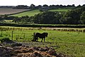 North Devon , Grassy Field ^ Pony - geograph.org.uk - 4636114.jpg 4,288 × 2,848; 6.75 MB
-
 North Devon , Grassy Field ^ Sheep - geograph.org.uk - 4636091.jpg 4,288 × 2,848; 5.97 MB
-
 North Devon , Grassy Field ^ Sheep - geograph.org.uk - 4636197.jpg 4,288 × 2,848; 5.35 MB
-
 North Devon , Grassy Path - geograph.org.uk - 4636049.jpg 2,848 × 4,288; 6.27 MB
-
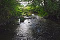
 North Devon , Little Silver Stream - geograph.org.uk - 4090661.jpg 4,288 × 2,848; 6.34 MB
-
 North Devon , Lower Uppacott Cross - geograph.org.uk - 4636117.jpg 4,288 × 2,848; 6.95 MB
-
 North Devon , Moorhouse Lane - geograph.org.uk - 4636054.jpg 4,288 × 2,848; 6.38 MB
-
 North Devon , Moorhouse Lane - geograph.org.uk - 4636056.jpg 4,288 × 2,848; 6.26 MB
-
 North Devon , Park Farm - geograph.org.uk - 4636072.jpg 4,288 × 2,848; 6.14 MB
-
 North Devon , The Barton - geograph.org.uk - 4636144.jpg 4,288 × 2,848; 6.02 MB
-
 North Devon , Tidlake Lane - geograph.org.uk - 4636200.jpg 2,848 × 4,288; 6.15 MB
-
 North Devon , Tidlake Lane - geograph.org.uk - 4636202.jpg 4,288 × 2,848; 6.18 MB
-
 North Devon - Country Lane (geograph 4636102).jpg 4,288 × 2,848; 6.34 MB
-
 North Devon - Country Lane (geograph 4636110).jpg 4,288 × 2,848; 6.34 MB
-
 North Devon - Grassy Field (geograph 4636098).jpg 4,288 × 2,848; 6.2 MB
-
 North Devon - Hilltown Cross (geograph 4636108).jpg 4,288 × 2,848; 6.11 MB
-
 Oak tree by the road to Mariansleigh - geograph.org.uk - 5812977.jpg 1,200 × 1,600; 766 KB
-

-
 Ordnance Survey Cut Mark - geograph.org.uk - 5281391.jpg 457 × 640; 142 KB
-
 Ordnance Survey Cut Mark - geograph.org.uk - 5281395.jpg 640 × 444; 86 KB
-
 Ordnance Survey Cut Mark - geograph.org.uk - 5281397.jpg 640 × 436; 65 KB
-
 Outbuildings at 'Townliving' - geograph.org.uk - 6232081.jpg 1,024 × 768; 186 KB
-
 Parish Hall, near Mariansleigh - geograph.org.uk - 642744.jpg 640 × 426; 51 KB
-
 Parsonage House, Mariansleigh - geograph.org.uk - 6232079.jpg 1,024 × 783; 232 KB
-
 Pasture near Eastacott - geograph.org.uk - 5247418.jpg 3,060 × 1,828; 1.01 MB
-
 Pasture near Eastacott - geograph.org.uk - 5247423.jpg 2,864 × 2,023; 1.29 MB
-
 Pasture near Westacott Farm - geograph.org.uk - 5082762.jpg 3,048 × 1,758; 1.6 MB
-
 Postbox, Church Room, Mariansleigh - geograph.org.uk - 5247716.jpg 1,727 × 2,466; 848 KB
-
 Road from Chulmleigh entering Alswear - geograph.org.uk - 4602912.jpg 1,600 × 1,200; 1.5 MB
-
 Road from Mariansleigh descending to Alswear - geograph.org.uk - 4602890.jpg 1,600 × 1,200; 1.54 MB
-
 Road into Alswear from Mariansleigh - geograph.org.uk - 5812951.jpg 1,200 × 1,600; 779 KB
-
 Road works at Bishop's Nympton Cross - geograph.org.uk - 5816503.jpg 1,600 × 1,200; 710 KB
-
 Scots Pine mark tree at Uppacott - geograph.org.uk - 300232.jpg 480 × 640; 49 KB
-
 Sculpture, Church Room, Mariansleigh - geograph.org.uk - 5247712.jpg 1,444 × 929; 255 KB
-
 St Mary’s church, Mariansleigh - geograph.org.uk - 5813337.jpg 1,600 × 1,200; 810 KB
-
 St Mary’s church, Mariansleigh - geograph.org.uk - 6232087.jpg 1,024 × 768; 212 KB
-
 Street furniture in Crooked Oaks, Alswear - geograph.org.uk - 3824314.jpg 3,859 × 5,789; 3.79 MB
-

-
 The Butcher's Arms, Alswear - geograph.org.uk - 4602899.jpg 1,200 × 1,600; 1.29 MB
-
 The Church Room, Mariansleigh - geograph.org.uk - 5813329.jpg 1,600 × 1,200; 806 KB
-
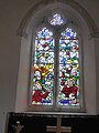 The east window of St Mary’s church, Mariansleigh - geograph.org.uk - 5813335.jpg 1,200 × 1,600; 838 KB
-
 The edge of Mariansleigh - geograph.org.uk - 5813304.jpg 1,600 × 1,200; 803 KB
-
 The farm at Hilltown near Mariansleigh (geograph 5816493).jpg 1,600 × 1,200; 789 KB
-
 Towards Uppacott - geograph.org.uk - 5082666.jpg 3,068 × 1,844; 1.42 MB
-
 Track near Trittencott Cross - geograph.org.uk - 5083437.jpg 1,920 × 1,213; 869 KB
-
 Track to Pitt Farm and browsing cows - geograph.org.uk - 5812976.jpg 1,600 × 1,200; 801 KB
-
 Trittencott Cross - geograph.org.uk - 5075975.jpg 1,920 × 1,280; 670 KB
-
 Trittencott Cross - geograph.org.uk - 5082854.jpg 2,685 × 1,272; 783 KB
-
 Trittencott Cross - geograph.org.uk - 5816513.jpg 1,600 × 1,200; 740 KB
-
 Uppacott Cross - geograph.org.uk - 5082664.jpg 3,060 × 1,867; 1.43 MB
-
 Uppacott Cross - geograph.org.uk - 6231195.jpg 1,024 × 824; 157 KB
-
 Valley and woodland south-west of Hilltown (geograph 5816494).jpg 1,600 × 1,200; 915 KB
-
 Valley south of Mariansleigh - geograph.org.uk - 5816482.jpg 1,600 × 1,200; 808 KB
-
 View over Crooked Oak valley - geograph.org.uk - 5247637.jpg 2,321 × 1,192; 588 KB
-
 Westacott Farm - geograph.org.uk - 5082679.jpg 1,920 × 1,009; 625 KB
-
 Woodland east of Alswear - geograph.org.uk - 5812955.jpg 1,200 × 1,600; 847 KB


.jpg)


.jpg)


.jpg)


.jpg)
.jpg)
.jpg)
.jpg)


.jpg)


.jpg)


