Category:Marktveld 20, Kloetinge
| Object location | | View all coordinates using: OpenStreetMap |
|---|
building in Goes, Netherlands  | |||||
| Upload media | |||||
| Instance of | |||||
|---|---|---|---|---|---|
| Location | Goes, Zeeland, Netherlands | ||||
| Street address |
| ||||
| Located on street |
| ||||
| Heritage designation |
| ||||
 | |||||
Nederlands: Buysgeboortehuis
|
This is a category about rijksmonument number 16436
|
| Address |
|
Media in category "Marktveld 20, Kloetinge"
The following 5 files are in this category, out of 5 total.
-
 Buysgeboortehuis.jpg 2,304 × 3,072; 2.96 MB
-
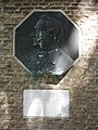
 Exterieur GEVELSTEEN - Kloetinge - 20290391 - RCE.jpg 1,198 × 1,200; 429 KB
-
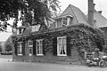
 Kloetinge Marktveld 20.jpg 2,288 × 1,712; 740 KB
-
 Overzicht - Kloetinge - 20125890 - RCE.jpg 1,200 × 793; 191 KB
-
 Zijgevel - Kloetinge - 20125891 - RCE.jpg 1,200 × 803; 248 KB


