Category:Marowijne District
Dansk: Marowijne er et distrikt i Surinam beliggende i den nordøstlige del af landet, grænsende mod Atlanterhavet og Fransk Guyana. Marowijnes hovedstad hedder Albina, og andre byer inkluderer Moengo og Wanhatti.
Deutsch: Marowijne ist ein Distrikt im äußersten Osten von Suriname, an der Grenze zu Französisch-Guyana. Hauptstadt ist Albina, benannt nach Albina Josefine Liezenmaier, der späteren Frau des Gründers der Niederlassung am Marowijne August Kappler.
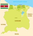
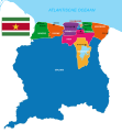
English: Marowijne is a district of Suriname, located on the north-east coast. Marowijne's capital city is Albina, with other towns including Moengo and Wanhatti. The district borders the Atlantic Ocean to the north, French Guiana to the east, the Surinamese district of Sipaliwini to the south and the Surinamese districts of Commewijne and Para to the west.
Español: Marowijne es uno de los diez sectores en los que se encuentra dividida la república de Surinam. Con una extensión de 4.627 km² y una población de 20.250 habitantes, limita al norte con el Océano Atlántico, al este con la Guyana Francesa, al sur con el distrito de Sipaliwini y al oeste con Commewijne y Para.
Français : Marowijne est un district du Nord-Ouest du Suriname tirant son nom du fleuve Maroni, Marowijne en néerlandais. Sa capitale est Albina, les autres villes importantes sont Moengo et Wanhatti. Situé en bordure de l'océan Atlantique il est limitrophe de la Guyane française à l'Est (Awala-Yalimapo, Saint-Laurent-du-Maroni, Mana) et des districts surinamais de Sipaliwini au Sud et de Commewijne et Para à l'Ouest.
Bahasa Indonesia: Distrik Marowijne merupakan sebuah distrik di Suriname yang memiliki luas wilayah 4.627 km² dan populasi 20.250 jiwa (2005). Ibu kotanya ialah Albina.
Italiano: Marowijne è uno dei 10 distretti del Suriname. Situato nell'estremo orientale del paese, al confine con la Guyana Francese la capitale è la città di Albina.
Lietuvių: Maroveino apygarda yra šiaurės rytų Suriname, Atlanto vandenyno pakrantėje, Prancūzų Gvianos pasienyje. Sostinė - Albina. Kiti miestai: Moengas, Vanhatis.
Nederlands: Marowijne is een district van Suriname, gelegen in het uiterste noordoosten van het land. In het noorden wordt het begrensd door de Atlantische Oceaan en in het oosten wordt het begrensd door de gelijknamige rivier de Marowijne, wat de grensrivier vormt met Frans-Guyana. In het westen grenst het district aan het district Commewijne en Para, en in het zuiden aan het district Sipaliwini. De hoofdplaats van Marowijne is Albina, het heeft 16.641 inwoners (2004) en een landoppervlakte van 4627 km².
Norsk bokmål: Marowijne er et av ti distrikter i Surinam. Det ligger helt nord-øst i landet, langs kysten og grenser til Fransk Guyana i øst. Tidlig på 1900-tallet ble det funnet bauxitt i Marowijne. Bauxittgruvene er fremdeles distriktets hovednæring. Det ligger også endel quilomboer i Marowijne. Dette er maroonbosettinger grunnlagt i kolonitiden av rømte slaver.
Polski: Marowijne to dystrykt w północno-wschodnim Surinamie, przy granicy z Gujaną Francuską. Stolicą dystryktu jest Albina, a innymi ważnymi miastami w regionie są Moengo i Wanhatti. Ludność Marowijne wynosi 20 250 mieszkańców, a powierzchnia 4 627 km².
Română: Districtul Marowijne este una dintre cele 10 unităţi administrativ-teritoriale de gradul I ale statului Surinam.
Русский: Маровейне — округ Суринама, расположенный на северо-восточном побережье. Столица — город Албина, другие города — Мунго и Ванхатти.
district of Suriname  .svg) | |||||
| Upload media | |||||
| Instance of | |||||
|---|---|---|---|---|---|
| Location | Suriname | ||||
| Capital | |||||
| Population |
| ||||
| Area |
| ||||
| Different from | |||||
 | |||||
Subcategories
This category has the following 19 subcategories, out of 19 total.
1
A
B
- Bigiston (12 F)
C
- Henk Chin A Sen (18 F)
G
M
- Moiwana Monument (4 F)
N
- Negerkreek (10 F)
P
- Pinatjaimi (15 F)
R
T
- Tamarin, Suriname (11 F)
Media in category "Marowijne District"
The following 23 files are in this category, out of 23 total.
-
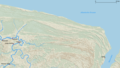 Cheniers NE Suriname.png 1,818 × 1,031; 2.15 MB
-
 District Marowijne - Suriname - Location Map.png 7,920 × 6,120; 894 KB
-
 Districten kaart van Suriname.svg 842 × 1,108; 1.42 MB
-
 Districts of Suriname with Capital Cities.svg 1,074 × 1,252; 203 KB
-
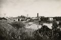 Fabrieksgebouwen te Moengo, KITLV 2144262.tiff 1,929 × 1,294; 7.17 MB
-
 Fabrieksgebouwen te Moengo, KITLV 2144263.tiff 2,007 × 1,230; 7.09 MB
-
 Gebodsbord op veerpont - 20653164 - RCE.jpg 1,191 × 1,200; 205 KB
-
 Map of Suriname - Marowijne Highlight.png 2,310 × 2,593; 212 KB
-
 Map of Suriname showing Districts and the capital cities.svg 1,448 × 1,572; 330 KB
-
 Marowijne (1).png 2,000 × 2,047; 110 KB
-
 Marowijne (2).png 1,188 × 878; 157 KB
-
 Marowijne (3).png 959 × 658; 49 KB
-
 Marowijne - Suriname.png 5,952 × 6,123; 689 KB
-
 Marowijne Resorts Suriname Neutral.png 8,419 × 5,953; 721 KB
-
 Marowijne resorts.png 1,056 × 816; 22 KB
-
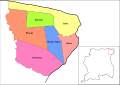 Marowijne resorts.svg 842 × 595; 336 KB
-
 Suriname Map of Regions and Provinces.svg 876 × 950; 305 KB
-
 Suriname-Marowijne.png 200 × 205; 4 KB
-
 Suriname-Marowijne.svg 595 × 558; 154 KB
-
 Suriname-Oppervlakte per district - Area per district in km2.svg 842 × 972; 441 KB
-
 The 10 Districts of Suriname - De 10 districten van Suriname.svg 595 × 612; 304 KB
-

-


.png)
.png)
.png)


