Category:Maryland Route 192
 | number: | (one hundred ninety-two) |
|---|---|---|
| State highways in Maryland: | 172 · 173 · 174 · 175 · 176 · 177 · 178 · 179 · 180 · 181 · 182 · 185 · 186 · 187 · 188 · 189 · 190 · 191 · 192 · 193 · 194 · 195 · 196 · 197 · 198 · 200 · 201 · 202 · 206 · 208 · 210 · 211 · 212 |
State highway in Montgomery County, Maryland, United States _at_Maryland_State_Route_185_(Connecticut_Avenue)_in_Kensington,_Montgomery_County,_Maryland.jpg) View east along Maryland State Route 192 (Plyers Mill Road) at Maryland State Route 185 (Connecticut Avenue) in Kensington, Montgomery County, Maryland  | |||||
| Upload media | |||||
| Instance of | |||||
|---|---|---|---|---|---|
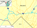
| Location | Montgomery County, Maryland | ||||
| Transport network | |||||
| Connects with | |||||
| Owned by | |||||
| Maintained by | |||||
| Inception |
| ||||
| Length |
| ||||
| Terminus |
| ||||
 | |||||
Subcategories
This category has only the following subcategory.
Media in category "Maryland Route 192"
The following 11 files are in this category, out of 11 total.
-
 2007 01 23 - 185@192 in Kensington NW.JPG 2,592 × 1,944; 1.49 MB
-
 2007 01 23 - 185@192@547 in Kensington S 1.JPG 2,592 × 1,944; 1.52 MB
-
 2007 01 23 - 185@192@547 in Kensington S 2.JPG 2,592 × 1,944; 1.48 MB
-
 2007 01 23 - 185@192@547 in Kensington SW 1.JPG 2,592 × 1,944; 1.54 MB
-
 2007 01 23 - 185@192@547 in Kensington SW 2.JPG 2,592 × 1,944; 1.48 MB
-
 2007 01 23 - 547 entering Kensington SE 1.JPG 2,592 × 1,944; 1.5 MB
-
 2007 01 23 - 547 entering Kensington SE 2.JPG 2,592 × 1,944; 1.47 MB
-
 2007 01 23 - 97@192 - Aerial looking S to SilverSpring.JPG 2,592 × 1,944; 1.43 MB
-
 2007 05 22 - 97@192 - NE corner 2.JPG 2,592 × 1,944; 1.26 MB
-
 Maryland Route 192 map.svg 990 × 765; 1.61 MB
-
 MD Route 192.svg 3,000 × 2,400; 10 KB


