Category:Matfield
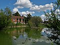
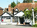
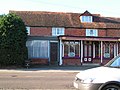
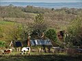
English: Matfield is a small village, part of the civil parish of Brenchley, in the Tunbridge Wells Borough of Kent, England. A striking feature of the village is a large pond on the village green. There are also two pubs: The Wheelwright's Arms; The Star
village in Kent, England, UK  | |||||
| Upload media | |||||
| Instance of | |||||
|---|---|---|---|---|---|
| Location | Brenchley and Matfield, Tunbridge Wells, Kent, South East England, England | ||||
 | |||||
Subcategories
This category has the following 7 subcategories, out of 7 total.
H
- Matfield House Cottages (2 F)
K
M
- Matfield House (4 F)
- Matfield War Memorial (1 F)
O
S
- The Star, Matfield (3 F)
Media in category "Matfield"
The following 116 files are in this category, out of 116 total.
-
 325 kent Matfield - Flickr - histogram man.jpg 6,000 × 3,977; 17.11 MB
-
 A Farm, off the Maidstone Rd, Matfield - geograph.org.uk - 1361007.jpg 640 × 430; 110 KB
-
 A footpath through an Orchard - geograph.org.uk - 1437875.jpg 640 × 480; 57 KB
-
-
 Apple orchard near Matfield (2) - geograph.org.uk - 1361171.jpg 640 × 430; 108 KB
-
 Applegarth House - geograph.org.uk - 1755737.jpg 640 × 361; 54 KB
-
 B2160 north of Matfield - geograph.org.uk - 2403789.jpg 640 × 430; 74 KB
-
 Boardwalk, Tudeley Brook (2) - geograph.org.uk - 1360468.jpg 640 × 430; 206 KB
-
 Boardwalk, Tudeley Brook - geograph.org.uk - 1360463.jpg 640 × 430; 196 KB
-
 Boughton Colemers - geograph.org.uk - 1755729.jpg 640 × 343; 54 KB
-
 Bramble Reed Lane - geograph.org.uk - 1360551.jpg 640 × 430; 190 KB
-
-
 Bridleway off Maidstone Rd, Matfield - geograph.org.uk - 1361011.jpg 640 × 430; 170 KB
-
-
 Coopers Lane, Matfield - geograph.org.uk - 2403783.jpg 640 × 382; 39 KB
-

-

-
 Crayford Lodge, Petteridge Lane - geograph.org.uk - 1756024.jpg 640 × 430; 117 KB
-
 Cryals Road - geograph.org.uk - 1220532.jpg 640 × 427; 106 KB
-
 Ebenezer Church, Matfield - geograph.org.uk - 1436191.jpg 640 × 480; 98 KB
-

-
 Farm buildings, Summerford Farm - geograph.org.uk - 1360451.jpg 640 × 430; 176 KB
-
 Fishing pond, Hayes View Farm (2) - geograph.org.uk - 1360656.jpg 640 × 430; 166 KB
-
 Fishing pond, Hayes View Farm - geograph.org.uk - 1360653.jpg 640 × 430; 184 KB
-
 Footbridge in Snipe Wood (1) - geograph.org.uk - 1409111.jpg 640 × 480; 99 KB
-
 Footbridge in Snipe Wood (2) - geograph.org.uk - 1409112.jpg 640 × 480; 110 KB
-
 Footpath junction is Snipe Wood - geograph.org.uk - 1409130.jpg 640 × 480; 128 KB
-
 Footpath to Brattles Grange - geograph.org.uk - 1438061.jpg 640 × 480; 122 KB
-
 Gate in wall, Gedges Farm - geograph.org.uk - 1436248.jpg 640 × 480; 124 KB
-
 Goshen Farm, Matfield - geograph.org.uk - 1361108.jpg 640 × 430; 127 KB
-

-
 High Weald Landscape Trail in Snipe Wood - geograph.org.uk - 1409138.jpg 640 × 480; 144 KB
-
 High Weald Walks heading to Pembury - geograph.org.uk - 1409181.jpg 640 × 480; 123 KB
-
 Houses an Foxhole Lane - geograph.org.uk - 1360447.jpg 640 × 388; 117 KB
-

-
 Long Distance Paths in Snipe Wood - geograph.org.uk - 1409124.jpg 640 × 480; 134 KB
-
 Maidstone Road, Matfield - geograph.org.uk - 1388674.jpg 640 × 480; 63 KB
-
 Marks and Sons, Butchers, Matfield - geograph.org.uk - 1361186.jpg 640 × 430; 128 KB
-
 Matfield fire station - geograph.org.uk - 588012.jpg 640 × 427; 207 KB
-
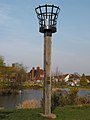 Matfield Millennium Beacon - geograph.org.uk - 2317534.jpg 1,200 × 1,600; 384 KB
-
 Matfield pond 1.jpg 3,888 × 5,184; 4.04 MB
-
 Matfield pond 2.jpg 5,184 × 3,888; 4.88 MB
-
 Matfield pond 3.jpg 5,184 × 3,888; 5.58 MB
-
 Matfield Post Office - geograph.org.uk - 1388657.jpg 640 × 480; 79 KB
-
 Matfield Post Office.jpg 1,545 × 1,203; 440 KB
-
 Matfield Village - geograph.org.uk - 71024.jpg 640 × 480; 142 KB
-
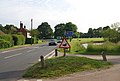
 Matfield Village Green - geograph.org.uk - 1360428.jpg 640 × 430; 128 KB
-
 Matfield village green.JPG 2,046 × 1,532; 1.75 MB
-
 Matfield Village Pond - geograph.org.uk - 71022.jpg 640 × 480; 170 KB
-

-
 Matfield, Fields near Kippings Cross.jpg 5,184 × 3,888; 5.48 MB
-
 Meadow near Summerford Farm - geograph.org.uk - 1360457.jpg 640 × 430; 167 KB
-
 Morello, Matfield - geograph.org.uk - 1025233.jpg 640 × 430; 54 KB
-
-
 New Vineyard on sunny south facing bank - geograph.org.uk - 1436279.jpg 640 × 480; 103 KB
-
 Orchard by the B2160 (Maidstone Rd) - geograph.org.uk - 1360967.jpg 640 × 430; 164 KB
-
-
 Orchard Cottage, Matfield - geograph.org.uk - 1361012.jpg 640 × 430; 136 KB
-
 Orchard south of Romford Rd - geograph.org.uk - 1360577.jpg 640 × 430; 169 KB
-
 Orchards by a footpath near Matfield - geograph.org.uk - 1360714.jpg 640 × 430; 102 KB
-
 Orchards near Cryals - geograph.org.uk - 1744946.jpg 640 × 430; 120 KB
-
 Orchards on a slope - geograph.org.uk - 1755740.jpg 640 × 453; 66 KB
-
 Orchards on a south facing slope - geograph.org.uk - 1755733.jpg 640 × 531; 72 KB
-
-

-
 Sophurst House and Sophurst Cottage - geograph.org.uk - 1437880.jpg 640 × 480; 58 KB
-

-

-
 The Black Path - geograph.org.uk - 1436171.jpg 640 × 480; 107 KB
-
 The end of the bridleway - geograph.org.uk - 1361037.jpg 640 × 430; 160 KB
-
 The George, Matfield - geograph.org.uk - 71027.jpg 640 × 480; 151 KB
-
-
 The Post Office, Matfield - geograph.org.uk - 1361188.jpg 640 × 430; 139 KB
-
 Thorn Barn, Matfield - geograph.org.uk - 1436201.jpg 640 × 480; 46 KB
-
 Thorn House, Matfield - geograph.org.uk - 1436208.jpg 640 × 480; 67 KB
-
 Tibbs Court Lane - geograph.org.uk - 1436168.jpg 640 × 480; 95 KB
-

-
 Wheelwrights Arms sign - geograph.org.uk - 2136353.jpg 480 × 640; 128 KB
-
 Wheelwrights Arms, Matfield - geograph.org.uk - 1388687.jpg 640 × 480; 67 KB
-
 Wheelwrights Arms, Matfield - geograph.org.uk - 2136348.jpg 640 × 480; 86 KB
-
 Woodland west of Bramble Reed Lane - geograph.org.uk - 1360569.jpg 640 × 430; 200 KB
-
 Becketts Grove Farm - geograph.org.uk - 1437891.jpg 640 × 480; 71 KB
-
 Bee hives in the orchards - geograph.org.uk - 357605.jpg 640 × 480; 127 KB
-
 Boardwalk near Great Hawkwell Cottage - geograph.org.uk - 1437797.jpg 640 × 480; 130 KB
-
 Bramley Farm House, Romford - geograph.org.uk - 1409169.jpg 640 × 480; 75 KB
-
 Bridleway junction in Horse Pasture - geograph.org.uk - 1437828.jpg 640 × 480; 143 KB
-
 Bridleway past Little Hawkwell Farm - geograph.org.uk - 1437811.jpg 640 × 480; 116 KB
-
 Converted Church, Walnut Tree - geograph.org.uk - 1436172.jpg 640 × 480; 107 KB
-

-
 Farm track to Pratt's Lane - geograph.org.uk - 1436230.jpg 640 × 480; 107 KB
-
 Footbridge in Horse Pasture - geograph.org.uk - 1437838.jpg 640 × 480; 109 KB
-
 Footbridge in Horse Pasture valley - geograph.org.uk - 1437823.jpg 640 × 480; 124 KB
-
 Footbridge in Slowery Wood - geograph.org.uk - 1437859.jpg 640 × 480; 102 KB
-
 Footpath in Beech Wood (2) - geograph.org.uk - 1437902.jpg 640 × 480; 124 KB
-
 Footpath in Beech Wood - geograph.org.uk - 1437899.jpg 640 × 480; 126 KB
-
 Footpath in Horse Pasture - geograph.org.uk - 1437831.jpg 480 × 640; 124 KB
-
 Footpath in Snipe Wood - geograph.org.uk - 1409135.jpg 640 × 480; 115 KB
-
 Footpath junction in Orchard - geograph.org.uk - 1438039.jpg 640 × 480; 105 KB
-
 Footpath junction near Albans Farm - geograph.org.uk - 1437843.jpg 640 × 480; 128 KB
-
 Footpath junction near Brattles Grange - geograph.org.uk - 1438064.jpg 640 × 480; 133 KB
-
 Footpath junction near Gedges Farm - geograph.org.uk - 1436238.jpg 640 × 480; 124 KB
-
 Footpath junction near Three Towns Farm - geograph.org.uk - 1437851.jpg 640 × 480; 147 KB
-
 Footpath junction on edge of Snipe Wood - geograph.org.uk - 1409142.jpg 640 × 480; 143 KB
-
 Footpath through an Orchard - geograph.org.uk - 1438029.jpg 640 × 480; 114 KB
-
 Footpath through Former Orchards - geograph.org.uk - 339371.jpg 640 × 428; 87 KB
-
 Footpath through Slowery Wood - geograph.org.uk - 1437856.jpg 640 × 480; 126 KB
-
 Footpath to Gedges Farm - geograph.org.uk - 1436255.jpg 640 × 480; 115 KB
-
 Gate in Orchard - geograph.org.uk - 1438054.jpg 640 × 480; 88 KB
-
 Hawkwell Barn - geograph.org.uk - 1437817.jpg 640 × 480; 76 KB
-
 Matfield village sign - geograph.org.uk - 337656.jpg 480 × 640; 97 KB
-
 Old-style bungalow - geograph.org.uk - 293703.jpg 640 × 427; 94 KB
-
 Orchard and Cinderhill Wood - geograph.org.uk - 356953.jpg 640 × 480; 75 KB
-
 To decorate or not^ - geograph.org.uk - 293690.jpg 640 × 427; 114 KB
-
 Water Tank - geograph.org.uk - 339364.jpg 640 × 428; 103 KB
-
 Wooded Kentish byway near Matfield. - geograph.org.uk - 191919.jpg 640 × 480; 186 KB
-
 Wooded road, near Matfield. - geograph.org.uk - 191920.jpg 640 × 480; 162 KB


_-_geograph.org.uk_-_1361171.jpg)


_-_geograph.org.uk_-_1360468.jpg)


_-_geograph.org.uk_-_1360656.jpg)

_-_geograph.org.uk_-_1409111.jpg)
_-_geograph.org.uk_-_1409112.jpg)


_-_geograph.org.uk_-_1360967.jpg)
_-_geograph.org.uk_-_1360960.jpg)


_-_geograph.org.uk_-_1361180.jpg)


_-_geograph.org.uk_-_1437902.jpg)


