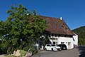
Category:Meierhaus (Bauernhaus) (Kirchstrasse 26–26b, St. Pantaleon)
| Object location | | View all coordinates using: OpenStreetMap |
|---|
rural house in Nuglar-St. Pantaleon in the canton of Solothurn, Switzerland  | |||||
| Upload media | |||||
| Instance of | |||||
|---|---|---|---|---|---|
| Part of | |||||
| Location | Nuglar-St. Pantaleon, Dorneck District, Dorneck-Thierstein, Solothurn, Switzerland | ||||
| Street address |
| ||||
| Heritage designation | |||||
 | |||||
Media in category "Meierhaus (Bauernhaus) (Kirchstrasse 26–26b, St. Pantaleon)"
This category contains only the following file.
-
 2014-Nuglar-St-Pantaleon-Meierhaus.jpg 1,500 × 1,000; 1.7 MB