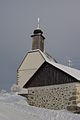
Category:Mesnerhaus hl. Michael ob Rauchenödt
Deutsch: Ehem. Mesnerhaus und Friedhof
| This category shows the protected monument with the number 21680 in Austria. (Commons, de, Wikidata) |
| Object location | | View all coordinates using: OpenStreetMap |
|---|
cemetery in Grünbach, Upper Austria, Austria  | |||||
| Upload media | |||||
| Instance of | |||||
|---|---|---|---|---|---|
| Location | Grünbach, Freistadt District, Upper Austria, Austria | ||||
| Street address |
| ||||
| Heritage designation | |||||
 | |||||
Media in category "Mesnerhaus hl. Michael ob Rauchenödt"
The following 4 files are in this category, out of 4 total.
-
 Infosaule St Michael Oberrauchenoedt.jpg 2,688 × 4,032; 1.2 MB
-
 Messnerhaus Oberrauchenoedt.jpg 4,032 × 2,688; 1.47 MB
-
 St Michael Mesnerhäusl 01.jpg 1,360 × 2,048; 1.14 MB
-
 St Michael Mesnerhäusl 02.jpg 2,048 × 1,360; 1.27 MB


