Category:Mill Square, Aintree
| Object location | | View all coordinates using: OpenStreetMap |
|---|
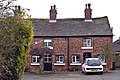
Former farmstead on Bull Bridge Lane, Aintree Village, consisting of seven houses, all Grade II listed.
Media in category "Mill Square, Aintree"
The following 4 files are in this category, out of 4 total.
-
 1 Mill Square, Aintree.jpg 4,028 × 3,431; 13.28 MB
-
 3 & 4 Mill Square, Aintree.jpg 4,608 × 3,298; 12.89 MB
-
 5 - 7 Mill Square, Aintree.jpg 4,880 × 3,249; 12.66 MB
-
 Mill Square, Aintree - geograph.org.uk - 1153722.jpg 640 × 480; 79 KB


