Category:Miller homestead (Rush County, Kansas)
|
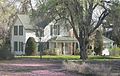
This is a category about a place or building that is listed on the National Register of Historic Places in the United States of America. Its reference number is 12000869. |
| Object location | | View all coordinates using: OpenStreetMap |
|---|
farm in Rush County, Kansas ,_silo_and_horse_barn_from_SE_1.JPG) | |||||
| Upload media | |||||
| Instance of | |||||
|---|---|---|---|---|---|
| Location | La Crosse, Rush County, Kansas | ||||
| Street address |
| ||||
| Heritage designation |
| ||||
| Inception |
| ||||
 | |||||
Media in category "Miller homestead (Rush County, Kansas)"
The following 8 files are in this category, out of 8 total.
-
 Miller homestead (Rush Co KS), horse barn from S 1.JPG 2,190 × 1,151; 734 KB
-
 Miller homestead (Rush Co KS), horse barn from SE 1.JPG 2,017 × 1,045; 513 KB
-
 Miller homestead (Rush Co KS), house and buildings from SE 1.JPG 2,166 × 1,024; 694 KB
-
 Miller homestead (Rush Co KS), house from SE 1.JPG 2,041 × 1,132; 899 KB
-
 Miller homestead (Rush Co KS), house from SW 1.JPG 1,758 × 1,113; 687 KB
-
 Miller homestead (Rush Co KS), silo and buildings from S 1.JPG 2,036 × 1,275; 636 KB
-
 Miller homestead (Rush Co KS), silo and horse barn from SE 1.JPG 2,154 × 1,137; 586 KB
-
 Miller homested (Rush Co KS), silo and buildings from SW 1.JPG 2,274 × 1,332; 744 KB
,_horse_barn_from_S_1.JPG)
,_horse_barn_from_SE_1.JPG)
,_house_and_buildings_from_SE_1.JPG)
,_house_from_SE_1.JPG)
,_house_from_SW_1.JPG)
,_silo_and_buildings_from_S_1.JPG)
,_silo_and_buildings_from_SW_1.JPG)