Category:Mississippi River Lock and Dam number 16
|
This is a category about a place or building that is listed on the National Register of Historic Places in the United States of America. Its reference number is 04000176. |
| Camera location | | View all coordinates using: OpenStreetMap |
|---|
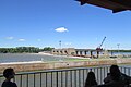
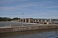
lock and dam on the Mississippi River near Muscatine, Iowa, USA  | |||||
| Upload media | |||||
| Instance of | |||||
|---|---|---|---|---|---|
| Location |
| ||||
| Architect | |||||
| Heritage designation |
| ||||
| Elevation above sea level |
| ||||
| Drainage basin | |||||
 | |||||
Subcategories
This category has only the following subcategory.
H
Media in category "Mississippi River Lock and Dam number 16"
The following 13 files are in this category, out of 13 total.
-
 Control Gates 2016-07-12 047.jpg 3,264 × 2,176; 2.15 MB
-
 Dam 2016-07-12 039.jpg 3,264 × 2,176; 1.54 MB
-
 Lock & Dam No 16 2016-07-12 038.jpg 3,264 × 2,176; 2.47 MB
-
 Mississippi River Lock and Dam number 16.jpg 1,500 × 1,001; 360 KB
-
 MississippiLockAndDam16 1.jpg 1,024 × 248; 72 KB
-
 MississippiLockAndDam16 2.jpg 1,024 × 680; 202 KB
-
 MississippiLockAndDam16 3.jpg 1,024 × 680; 220 KB
-
 Tow 2016-07-12 040.jpg 3,264 × 2,176; 1.53 MB
-
 Tow 2016-07-12 041.jpg 3,264 × 2,176; 1.74 MB
-
 Tow 2016-07-12 043.jpg 3,264 × 2,176; 1.78 MB
-
 Tow 2016-07-12 046.jpg 3,264 × 2,176; 1.49 MB
-
 Trip 2016-07-12 042.jpg 3,264 × 2,176; 1.91 MB
-
 Trip 2016-07-12 045.jpg 3,264 × 2,176; 2 MB


