Category:Moni Fotodotis in Naxos
| Object location | | View all coordinates using: OpenStreetMap |
|---|
fortified monastery in Naxos and Small Cyclades Municipality, Greece   | |||||
| Upload media | |||||
| Instance of | |||||
|---|---|---|---|---|---|
| Location | Danakos, Naxos, Commune of Danakos, Drymalia Municipal Unit, Naxos and Lesser Cyclades Municipality, Naxos Regional Unit, South Aegean Region, Decentralized Administration of the Aegean, Greece | ||||
 | |||||
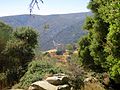
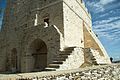
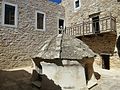
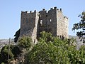
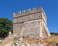
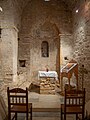
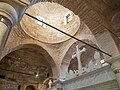
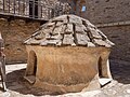
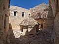
The monastery Moni Fotodotis (Photodotis) was created around the church Christos Fotodotis (Christ Giver of Light, 6th-12th centuries) in the mountains of Naxos. In the 15th century, the monastery was later fortified. Now the monastery is empty, but repaired.
Subcategories
This category has only the following subcategory.
C
Pages in category "Moni Fotodotis in Naxos"
This category contains only the following page.
Media in category "Moni Fotodotis in Naxos"
The following 47 files are in this category, out of 47 total.
-
 Moni Fotodotis from way from Apeiranthos, Naxos, 13M535.jpg 2,816 × 2,112; 4.74 MB
-
 Moni Fotodotis Naxos 10-15 c AD 119691.jpg 3,471 × 2,311; 5.23 MB
-
 Moni Fotodotis Naxos 10-15 c AD 13M550.jpg 2,816 × 2,112; 3.64 MB
-
 Moni Fotodotis Naxos 10-15 c AD 13M553.jpg 2,816 × 2,112; 4.25 MB
-
 Moni Fotodotis Naxos 10-15 c AD 13M556.jpg 2,816 × 2,112; 3.71 MB
-
 Moni Fotodotis Naxos 10-15 c AD 13M557.jpg 2,112 × 2,816; 2.15 MB
-
 Moni Fotodotis Naxos 10-15 c AD 13M560.jpg 2,816 × 2,112; 3.63 MB
-
 Moni Fotodotis Naxos 10-15 c AD 13M561.jpg 2,816 × 2,112; 3.93 MB
-
 Moni Fotodotis Naxos 10-15 c AD 13M577.jpg 2,816 × 2,112; 4.18 MB
-
 Moni Fotodotis Naxos 119682.jpg 3,471 × 2,311; 6.14 MB
-
 Moni Fotodotis Naxos 13M587.jpg 2,816 × 2,112; 4.99 MB
-
 Moni Fotodotis Naxos 15 c AD 119690.jpg 2,311 × 3,471; 5.28 MB
-
 Moni Fotodotis Naxos 15 c AD 119692.jpg 3,471 × 2,311; 6 MB
-
 Moni Fotodotis Naxos 15 c AD 119701.jpg 2,311 × 3,471; 5.21 MB
-
 Moni Fotodotis Naxos 6-15 c AD 119685.jpg 3,391 × 2,256; 5.12 MB
-
 Moni Fotodotis Naxos 6-15 c AD 119694.jpg 3,355 × 2,146; 4.98 MB
-
 Moni Fotodotis Naxos 6-15 c AD 119695.jpg 3,471 × 2,311; 5.13 MB
-
 Moni Fotodotis Naxos 6-15 c AD 119696.jpg 3,471 × 2,311; 4.34 MB
-
 Moni Fotodotis Naxos 6-15 c AD 119697.jpg 3,471 × 2,311; 5.7 MB
-
 Moni Fotodotis Naxos 6-15 c AD 119698.jpg 2,311 × 3,471; 5.03 MB
-
 Moni Fotodotis Naxos 6-15 c AD 119699.jpg 3,471 × 2,311; 5.69 MB
-
 Moni Fotodotis Naxos 6-15 c AD 119700.jpg 3,471 × 2,311; 6.26 MB
-
 Moni Fotodotis Naxos 6-15 c AD 13M568.jpg 2,816 × 2,112; 3.71 MB
-
 Moni Fotodotis Naxos 6-15 c AD 13M569.jpg 2,816 × 2,112; 4.49 MB
-
 Moni Fotodotis Naxos 6-15 c AD 13M572.jpg 2,816 × 2,112; 4.09 MB
-
 Moni Fotodotis Naxos 6-15 c AD 13M592.jpg 2,816 × 1,916; 3.96 MB
-
 Moni Fotodotis Naxos Greece 10-15 c AD 2003081616140N01342.jpg 2,272 × 1,704; 1.27 MB
-
 Moni Fotodotis Naxos Greece 10-15 c AD 2003081616190N01343.jpg 2,272 × 1,704; 1.26 MB
-
 Moni Fotodotis Naxos Greece 10-15 c AD 2003081616240N01345.jpg 2,272 × 1,704; 1.25 MB
-
 Moni Fotodotis, arrival from Ag. Marina, Naxos, 176807.jpg 5,297 × 3,531; 8.93 MB
-
 Moni Fotodotis, arrival from Danakos, Naxos, 176824.jpg 5,472 × 3,648; 9.56 MB
-
 Moni Fotodotis, bell, Naxos, 176823.jpg 5,424 × 3,616; 9.07 MB
-
 To Moni Fotodoti, Naxos, 119672.jpg 3,471 × 2,311; 6.25 MB
-
 View from Moni Fotodotis (Naxos) at Makares Nisia and Donoussa 13M571.jpg 2,816 × 2,112; 3.66 MB
-
 Μονή Φωτοδότη 7317.jpg 4,193 × 3,145; 5.79 MB
-
 Μονή Φωτοδότη 7319.jpg 4,011 × 3,209; 6.19 MB
-
 Μονή Φωτοδότη 7320.jpg 3,990 × 3,192; 6.39 MB
-
 Μονή Φωτοδότη 7321.jpg 3,990 × 3,192; 6.65 MB
-
 Μονή Φωτοδότη 7322.jpg 3,456 × 4,608; 7.92 MB
-
 Μονή Φωτοδότη 7325-HDR.jpg 4,589 × 3,442; 6.73 MB
-
 Μονή Φωτοδότη 7330.jpg 3,416 × 4,555; 7.25 MB
-
 Μονή Φωτοδότη 7332.jpg 4,608 × 3,456; 8.12 MB
-
 Μονή Φωτοδότη 7334.jpg 4,016 × 3,012; 6.26 MB
-
 Μονή Φωτοδότη 7337.jpg 4,494 × 3,371; 6.93 MB
-
 Μονή Φωτοδότη 7338.jpg 4,608 × 3,456; 7.88 MB
-
 Μονή Φωτοδότη 7339.jpg 4,608 × 3,456; 7.48 MB
-
 Φωτοδότης.jpg 3,264 × 2,131; 781 KB


_at_Makares_Nisia_and_Donoussa_13M571.jpg)


