Category:Monsal Trail

bridleway in the English Peak District  | |||||
| Upload media | |||||
| Instance of | |||||
|---|---|---|---|---|---|
| Located in protected area |
| ||||
| Location | Derbyshire, East Midlands, England | ||||
| Terminus | |||||
 | |||||
Subcategories
This category has the following 17 subcategories, out of 17 total.
B
- Bakewell railway station (33 F)
C
- Chee Tor Tunnels (25 F)
- Coombs Road Viaduct (7 F)
- Cressbrook Tunnel (24 F)
E
- East Buxton Lime (11 F)
G
- Great Longstone railway station (27 F)
H
- Haddon Tunnel (4 F)
- Hassop railway station (31 F)
- Headstone Tunnel (37 F)
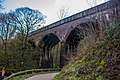
- Headstone Viaduct (87 F)
L
- Litton Tunnel (17 F)
M
- Millers Dale Bridge 75 (7 F)
- Millers Dale railway station (32 F)
- Millers Dale South Viaduct (22 F)
R
- Rusher Cutting Tunnel (15 F)
Media in category "Monsal Trail"
The following 200 files are in this category, out of 358 total.
(previous page) (next page)-
 "Can we go back home now" - geograph.org.uk - 1145680.jpg 640 × 450; 96 KB
-
 "Stop" Sign on the Monsal Trail.jpg 3,648 × 2,736; 1.83 MB
-
 500px photo (45279614).jpeg 2,048 × 1,536; 1.22 MB
-
 A cutting along the Monsal Trail - geograph.org.uk - 2032748.jpg 640 × 480; 139 KB
-
 A cutting on the Monsal Trail - geograph.org.uk - 5068582.jpg 3,456 × 2,304; 4.72 MB
-

-
 A quiet wet Monsal Trail in early January - geograph.org.uk - 4303123.jpg 1,024 × 768; 307 KB
-
 A rainy end to the Monsal Trail - geograph.org.uk - 4303516.jpg 1,024 × 768; 249 KB
-
 A6020 from the Monsal Trail - geograph.org.uk - 2612816.jpg 1,024 × 768; 372 KB
-
 A619 Bridge over the Monsal Trail - geograph.org.uk - 4822613.jpg 640 × 426; 91 KB
-
 A619 Bridge over the Monsal Trail - geograph.org.uk - 4822623.jpg 640 × 426; 97 KB
-
 Access bridge over the Monsal Trail - geograph.org.uk - 4808054.jpg 640 × 426; 97 KB
-
 Access bridge over the Monsal Trail - geograph.org.uk - 4808056.jpg 640 × 426; 103 KB
-
 Access bridge, Monsal Trail - geograph.org.uk - 4808410.jpg 640 × 426; 111 KB
-
 Access bridge, Monsal Trail - geograph.org.uk - 4808437.jpg 640 × 426; 102 KB
-
 Access Bridge, The Monsal Trail - geograph.org.uk - 4813887.jpg 640 × 426; 107 KB
-

-
 Autumn scene from Monsal Trail - geograph.org.uk - 3746560.jpg 4,912 × 3,264; 7.66 MB
-
 B6001 Bridge, The Monsal Trail - geograph.org.uk - 4813939.jpg 640 × 426; 104 KB
-
 B6001 Bridge, The Monsal Trail - geograph.org.uk - 4822525.jpg 640 × 426; 96 KB
-
 Bakewell Show nearly ready - geograph.org.uk - 1430774.jpg 640 × 480; 79 KB
-

-
 Bakewell, from the Monsal Trail - geograph.org.uk - 2731636.jpg 3,648 × 2,736; 4.31 MB
-

-
 Baslow Road Bridge - geograph.org.uk - 2338571.jpg 640 × 480; 90 KB
-
 Baslow Road railway bridge over the Monsal Trail - geograph.org.uk - 3453444.jpg 2,048 × 1,536; 660 KB
-
 Bench on the Monsal Trail - geograph.org.uk - 4763137.jpg 768 × 1,024; 237 KB
-
 Bridge by Bakewell Station - geograph.org.uk - 4748396.jpg 6,000 × 4,000; 4.42 MB
-

-
 Bridge on the Monsal Trail - geograph.org.uk - 586951.jpg 640 × 430; 89 KB
-
 Bridge over former railway line - geograph.org.uk - 1765443.jpg 640 × 480; 111 KB
-
 Bridge over the Monsal Trail - geograph.org.uk - 1366017.jpg 640 × 480; 104 KB
-
 Bridge over the Monsal Trail - geograph.org.uk - 1704938.jpg 800 × 600; 180 KB
-
 Bridge over the Monsal Trail - geograph.org.uk - 2682219.jpg 1,024 × 768; 261 KB
-
 Bridge over the Monsal Trail - geograph.org.uk - 3464652.jpg 2,048 × 1,536; 1.71 MB
-
 Bridge over The Monsal Trail - geograph.org.uk - 4786491.jpg 640 × 426; 94 KB
-
 Bridge over The Monsal Trail - geograph.org.uk - 4803206.jpg 640 × 426; 96 KB
-
 Bridge over The Monsal Trail - geograph.org.uk - 4803209.jpg 640 × 426; 89 KB
-
 Bridge over the Monsal Trail - geograph.org.uk - 4822965.jpg 640 × 426; 108 KB
-
 Bridge over the Monsal Trail - geograph.org.uk - 5212266.jpg 1,280 × 853; 425 KB
-

-

-
 Bridge over Track - geograph.org.uk - 2527188.jpg 427 × 640; 293 KB
-
 Bridge Under The Monsal Trail - geograph.org.uk - 3608750.jpg 2,048 × 1,536; 1.66 MB
-
 Bridge, Litton Mill Cutting - geograph.org.uk - 4798109.jpg 640 × 426; 119 KB
-
 Bridge, Litton Mill Cutting - geograph.org.uk - 4798124.jpg 640 × 426; 114 KB
-
 Bridleway crosses the Monsal Trail - geograph.org.uk - 4813933.jpg 640 × 426; 115 KB
-

-
 Bridleway to Monsal Trail - geograph.org.uk - 4786429.jpg 640 × 426; 96 KB
-
 Buxton bound from Hassop Station - geograph.org.uk - 244821.jpg 640 × 480; 341 KB
-
 By the Monsal Trail - geograph.org.uk - 4813876.jpg 640 × 426; 97 KB
-

-
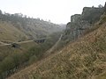 Chee Dale and the Monsal Trail - geograph.org.uk - 1081359.jpg 640 × 480; 77 KB
-
 Chee Dale from Monsal Trail, Peak District, Derbyshire (8120059506).jpg 2,592 × 1,944; 2.79 MB
-
 Chee Dale with Monsal Trail Viaduct - geograph.org.uk - 452594.jpg 640 × 480; 114 KB
-
 Chee Dale, footbridge to join Monsal Trail.jpg 2,250 × 3,000; 2.4 MB
-
 Chee Dale, Monsal Trail, Peak District, Derbyshire (8120072362).jpg 2,592 × 1,944; 1.68 MB
-
 Chee Tor Tunnels 2 ^ 1 - geograph.org.uk - 2829568.jpg 2,608 × 1,952; 1.63 MB
-
 Chee Tunnels, Monsal Trail, Peak District, Derbyshire (8120042449).jpg 2,592 × 1,944; 1.66 MB
-
 Coppicing by The Monsal Trail - geograph.org.uk - 4822679.jpg 640 × 426; 118 KB
-
 Cottages in Chee Dale (3) - geograph.org.uk - 1765473.jpg 640 × 480; 93 KB
-

-
 Cressbrook Mill - geograph.org.uk - 62081.jpg 640 × 369; 76 KB
-
 Cressbrook Mill 1.jpg 3,648 × 2,736; 1.99 MB
-
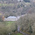 Cressbrook Mill from the Monsal Trail - geograph.org.uk - 5209014.jpg 1,280 × 1,280; 445 KB
-
 Cutting on The Monsal Trail - geograph.org.uk - 4786492.jpg 640 × 426; 86 KB
-
 Cutting, The Monsal Trail - geograph.org.uk - 4786498.jpg 640 × 426; 102 KB
-
 Cutting, The Monsal Trail - geograph.org.uk - 4798054.jpg 640 × 426; 100 KB
-
 Cycling the Monsal Trail - geograph.org.uk - 4813935.jpg 640 × 426; 83 KB
-
 Cyclist, The Monsal Trail - geograph.org.uk - 4798036.jpg 640 × 426; 105 KB
-
 Cyclists, The Monsal Trail - geograph.org.uk - 4786514.jpg 640 × 426; 110 KB
-
 Cyclists, The Monsal Trail - geograph.org.uk - 4813896.jpg 640 × 426; 96 KB
-
 Dewpond partly frozen - geograph.org.uk - 1143961.jpg 640 × 480; 62 KB
-

-
 Dry stone wall and fields - geograph.org.uk - 1111994.jpg 640 × 480; 78 KB
-
 Entrance to Headstone Tunnel.jpg 3,648 × 2,736; 1.96 MB
-
 Falling Rocks Sign, Monsal Trail.jpg 3,648 × 2,736; 1.99 MB
-

-
 Farmland by the Monsal Trail - geograph.org.uk - 4822686.jpg 640 × 426; 96 KB
-
 Field by the Monsal Trail - geograph.org.uk - 4813874.jpg 640 × 426; 65 KB
-
 Finger post on the Monsal Trail - geograph.org.uk - 5212284.jpg 1,280 × 853; 442 KB
-
 Finger post on the Monsal Trail - geograph.org.uk - 5212298.jpg 1,280 × 853; 451 KB
-
 Footbridge over River Wye in Millers Dale - geograph.org.uk - 519126.jpg 640 × 480; 133 KB
-
 Footbridge over the Monsal Trail - geograph.org.uk - 3074182.jpg 800 × 600; 153 KB
-
 Footbridge over The Monsal Trail - geograph.org.uk - 4303109.jpg 1,024 × 777; 302 KB
-
 Footbridge, The Monsal Trail - geograph.org.uk - 4813863.jpg 640 × 426; 108 KB
-
 Footbridge, The Monsal Trail - geograph.org.uk - 4813864.jpg 640 × 426; 110 KB
-
 Footpath crossing The Monsal Trail - geograph.org.uk - 4798024.jpg 640 × 426; 105 KB
-
 Footpath near Great Longstone - geograph.org.uk - 1747034.jpg 3,296 × 2,472; 1.07 MB
-
 Footpath off the Monsal Trail - geograph.org.uk - 4797991.jpg 640 × 426; 102 KB
-
 Footpath sign on the Monsal Trail - geograph.org.uk - 4797331.jpg 640 × 426; 124 KB
-
 Footpath sign, Monsal Trail - geograph.org.uk - 4798066.jpg 640 × 426; 104 KB
-
 Footpath sign, The Monsal Trail - geograph.org.uk - 4786499.jpg 640 × 426; 105 KB
-
 Footpath sign, The Monsal Trail - geograph.org.uk - 4803219.jpg 640 × 426; 118 KB
-

-
 Footpath signpost, The Monsal Trail - geograph.org.uk - 4813867.jpg 640 × 426; 102 KB
-
 Footpath signpost, The Monsal Trail - geograph.org.uk - 4813878.jpg 640 × 426; 115 KB
-
 Footpath to Bakewell from Monsal Trail - geograph.org.uk - 720722.jpg 640 × 480; 121 KB
-
 Footpath under bridge - geograph.org.uk - 1587995.jpg 640 × 480; 81 KB
-
-
 From the Monsal trail - geograph.org.uk - 5094219.jpg 3,264 × 2,448; 3.02 MB
-
 Graffiti in Cressbrook Tunnel 01.jpg 3,648 × 2,736; 2.01 MB
-
 Graffiti in Cressbrook Tunnel 2.jpg 3,648 × 2,736; 1.81 MB
-
 Graffiti in Cressbrook Tunnel.jpg 3,648 × 2,736; 1.93 MB
-
 Great Longstone Railway Station.jpg 5,184 × 2,920; 6.47 MB
-
 Harebell 1.jpg 1,763 × 1,634; 239 KB
-
 Hassop station and nearby 2017 03.jpg 5,184 × 3,456; 16.68 MB
-
 Hassop station and nearby 2017 04.jpg 5,184 × 3,456; 16.28 MB
-
 Hassop station and nearby 2017 05.jpg 5,184 × 3,456; 12.48 MB
-
 Hassop station and nearby 2017 06.jpg 5,184 × 3,456; 14.81 MB
-
 Hillside by The Monsal Trail - geograph.org.uk - 4822689.jpg 640 × 426; 80 KB
-
 House by The Monsal Trail - geograph.org.uk - 4822620.jpg 640 × 426; 88 KB
-
 Information board by the Monsal Trail - geograph.org.uk - 4797554.jpg 640 × 426; 108 KB
-
 Inside Cressbrook Tunnel 1.jpg 3,648 × 2,736; 1.89 MB
-
 Lane junction from the Monsal Trail - geograph.org.uk - 2032750.jpg 640 × 480; 128 KB
-
 Laying a new pipe, The Monsal Trail - geograph.org.uk - 4798072.jpg 640 × 426; 105 KB
-
 Limestone by the Monsal Trail - geograph.org.uk - 4798130.jpg 640 × 426; 131 KB
-
 Limestone by the Monsal Trail - geograph.org.uk - 4798139.jpg 640 × 426; 116 KB
-
 Limestone cliff by The Monsal Trail - geograph.org.uk - 4786495.jpg 640 × 426; 108 KB
-
 Litton Mill Cutting, Monsal Trail - geograph.org.uk - 4798104.jpg 640 × 426; 105 KB
-
 Longstone Lane Bridge, Monsal Trail - geograph.org.uk - 4808426.jpg 640 × 426; 95 KB
-
 Midland Lines.jpg 5,541 × 4,016; 11.99 MB
-

-

-

-

-
 Miller's dale railway cutting - geograph.org.uk - 765406.jpg 640 × 426; 110 KB
-
 Millers Dale along the Monsal Trail - geograph.org.uk - 666.jpg 640 × 480; 49 KB
-
 Millers Dale Railway Station.jpg 5,184 × 2,920; 7.76 MB
-
 Monsal Dale - geograph.org.uk - 1589877.jpg 640 × 480; 125 KB
-

-
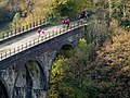
 Monsal Head Viaduct view towards tunnel - geograph.org.uk - 244921.jpg 640 × 480; 376 KB
-
 Monsal trail (19012947488).jpg 4,791 × 3,179; 5.68 MB
-
 Monsal Trail - cutting bridge - geograph.org.uk - 2033570.jpg 640 × 480; 161 KB
-
 Monsal Trail - geograph.org.uk - 1247324.jpg 640 × 426; 72 KB
-
 Monsal Trail - geograph.org.uk - 1726091.jpg 2,560 × 1,920; 1.72 MB
-
 Monsal Trail - geograph.org.uk - 1963313.jpg 800 × 600; 135 KB
-
 Monsal Trail - geograph.org.uk - 2264838.jpg 3,648 × 2,736; 6.34 MB
-
 Monsal Trail - geograph.org.uk - 2854207.jpg 640 × 424; 254 KB
-
 Monsal Trail - geograph.org.uk - 2854890.jpg 640 × 424; 259 KB
-
 Monsal Trail - geograph.org.uk - 2854934.jpg 640 × 424; 315 KB
-
 Monsal Trail - geograph.org.uk - 2854978.jpg 640 × 424; 310 KB
-
 Monsal Trail - geograph.org.uk - 2855132.jpg 640 × 424; 309 KB
-
 Monsal Trail - geograph.org.uk - 5059295.jpg 3,264 × 2,448; 3.11 MB
-
 Monsal Trail - geograph.org.uk - 5493824.jpg 5,184 × 3,456; 1.69 MB
-
 Monsal Trail - geograph.org.uk - 5493846.jpg 3,456 × 4,751; 1.72 MB
-
 Monsal Trail - geograph.org.uk - 5494626.jpg 4,827 × 3,404; 2.02 MB
-
 Monsal Trail - geograph.org.uk - 5495168.jpg 5,184 × 3,456; 2.02 MB
-
 Monsal Trail - geograph.org.uk - 5495173.jpg 4,940 × 3,376; 1.66 MB
-
 Monsal Trail - geograph.org.uk - 5495175.jpg 5,101 × 3,456; 1.9 MB
-
 Monsal Trail - geograph.org.uk - 5495180.jpg 5,036 × 2,979; 2.04 MB
-
 Monsal Trail - geograph.org.uk - 5495187.jpg 4,831 × 3,441; 1.87 MB
-
 Monsal Trail - Hassop Station now a cafe - geograph.org.uk - 2033564.jpg 640 × 480; 111 KB
-
 Monsal Trail - near the eastern end - geograph.org.uk - 2033595.jpg 640 × 480; 124 KB
-

-

-
 Monsal Trail 2018 001.jpg 5,184 × 3,456; 12.26 MB
-
 Monsal Trail 2018 002.jpg 5,184 × 3,456; 11.96 MB
-
 Monsal Trail 2018 003.jpg 5,184 × 3,456; 11.4 MB
-
 Monsal Trail 2018 004.jpg 5,184 × 3,456; 9.74 MB
-
 Monsal Trail 2018 005.jpg 5,184 × 3,456; 13.41 MB
-
 Monsal Trail 2018 006.jpg 5,184 × 3,456; 12.32 MB
-
 Monsal Trail 2018 007.jpg 5,184 × 3,456; 16.47 MB
-
 Monsal Trail 2018 008.jpg 5,184 × 3,456; 10.69 MB
-
 Monsal Trail 2018 009.jpg 5,184 × 3,456; 13.22 MB
-
 Monsal Trail 2018 010.jpg 5,184 × 3,456; 12.97 MB
-
 Monsal Trail 2018 011.jpg 5,184 × 3,456; 12.16 MB
-
 Monsal Trail 2018 012.jpg 5,184 × 3,456; 13.01 MB
-
 Monsal Trail 2018 013.jpg 3,456 × 5,184; 12.55 MB
-
 Monsal Trail 2018 014.jpg 5,184 × 3,456; 13.88 MB
-
 Monsal Trail 2018 015.jpg 5,184 × 3,456; 11.17 MB
-
 Monsal Trail 2018 016.jpg 5,184 × 3,456; 12.25 MB
-
 Monsal Trail 2018 017.jpg 5,184 × 3,456; 12.69 MB
-
 Monsal Trail 2018 018.jpg 5,184 × 3,456; 14 MB
-
 Monsal Trail 2018 019.jpg 5,184 × 3,456; 11.98 MB
-
 Monsal Trail 2018 020.jpg 3,456 × 5,184; 11.88 MB
-
 Monsal Trail 2018 021.jpg 5,184 × 3,456; 13.2 MB
-
 Monsal Trail 2018 022.jpg 3,456 × 5,184; 11.98 MB
-
 Monsal Trail 2018 023.jpg 3,456 × 5,184; 10.54 MB
-
 Monsal Trail 2018 024.jpg 5,184 × 3,456; 10.2 MB
-
 Monsal Trail 2018 025.jpg 3,456 × 5,184; 11.77 MB
-
 Monsal Trail 2018 026.jpg 5,184 × 3,456; 13.14 MB
-
 Monsal Trail 2018 027.jpg 3,456 × 5,184; 13.35 MB
-
 Monsal Trail 2018 028.jpg 5,184 × 3,456; 12.53 MB
-
 Monsal Trail 2018 029.jpg 5,184 × 3,456; 15.03 MB
-
 Monsal Trail 2018 030.jpg 3,456 × 5,184; 12.39 MB
-
 Monsal Trail 2018 044.jpg 5,184 × 3,456; 10.87 MB
-
 Monsal Trail 2018 045.jpg 5,184 × 3,456; 10.35 MB
-
 Monsal Trail 2018 046.jpg 5,184 × 3,456; 16.4 MB
-
 Monsal Trail 2018 047.jpg 5,184 × 3,456; 12.84 MB
-
 Monsal Trail 2018 048.jpg 5,184 × 3,456; 13.21 MB
-
 Monsal Trail 2018 049.jpg 5,184 × 3,456; 13.18 MB
-
 Monsal Trail 2018 050.jpg 5,184 × 3,456; 16.41 MB
-
 Monsal Trail 2018 051.jpg 3,456 × 5,184; 13.87 MB
-
 Monsal Trail 2018 052.jpg 3,456 × 5,184; 11.55 MB
-
 Monsal Trail 2018 053.jpg 5,184 × 3,456; 14.16 MB
-
 Monsal Trail 2018 054.jpg 3,456 × 5,184; 12.89 MB
-

-

-


.jpeg)


_Crosses_Monsal_Trail_-_geograph.org.uk_-_720741.jpg)


.jpg)


.jpg)

.jpg)

_-_geograph.org.uk_-_1765473.jpg)


.jpg)


