Category:Mont Brûlé
mountain shared by Switzerland and Italy  | |||||
| Upload media | |||||
| Instance of | |||||
|---|---|---|---|---|---|
| Part of | |||||
| Location | Valais, Switzerland | ||||
| Mountain range | |||||
| Topographic prominence |
| ||||
| Topographic isolation |
| ||||
| Elevation above sea level |
| ||||
| Different from | |||||
 | |||||
Media in category "Mont Brûlé"
The following 2 files are in this category, out of 2 total.
-
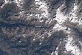 ISS067-E-152527 - View of Earth.jpg 5,568 × 3,712; 3.09 MB
-
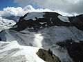 MontBrule.jpg 1,600 × 1,200; 686 KB
