Category:Mowbray, Cape Town
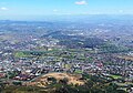
English: Mowbray is one of the Southern Suburbs of Cape Town, South Africa and lies on the slopes of Devil's Peak. Mowbray is at a junction of several major Cape Town highways and has an important multi-modal public transport interchange at Mowbray railway station. Its original name was Driekoppen (In Dutch, "Three heads").
suburb of Cape Town, South Africa  | |||||
| Upload media | |||||
| Instance of | |||||
|---|---|---|---|---|---|
| Location | City of Cape Town, Western Cape, RSA | ||||
| Area |
| ||||
| Elevation above sea level |
| ||||
 | |||||
Media in category "Mowbray, Cape Town"
The following 14 files are in this category, out of 14 total.
-
 Albert Street Mowbray.JPG 3,209 × 2,643; 2.61 MB
-
 Cape Town - St Peter's Cemetery, Main Road, Mowbray.JPG 800 × 536; 404 KB
-
 Grove Road Mowbray.JPG 3,466 × 2,599; 2.63 MB
-
 Mowbray 3 Avenue Road.JPG 3,648 × 2,736; 4.08 MB
-
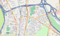
 Mowbray OSM map small.svg 430 × 259; 1.13 MB
-
 Mowbray OSM map.svg 1,291 × 779; 4.14 MB
-
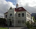 Mowbray Town Hall.JPG 3,208 × 2,616; 2.57 MB
-
 Plameňáci v Kapském městě - panoramio.jpg 4,928 × 3,264; 12.09 MB
-
 Pub Lib Mowbray.JPG 537 × 340; 51 KB
-

-
 Table Mountain-Kings Blockhouse-001.jpg 1,280 × 857; 199 KB
-
-
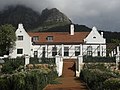
 Welgelegen Homestead, Mowbray, Cape Town.jpg 2,560 × 1,701; 2.47 MB
-
 Welgelegen UCT.JPG 3,483 × 2,612; 1.94 MB


